
For hunters in Canada, picking the right digital tool isn't as simple as downloading the most popular app. The reality is, most of the big-name hunting apps are built for the American market. The best hunting app for Canada needs to be built from the ground up with Canadian-specific features—I'm talking about precise Crown Land layers, provincial Wildlife Management Unit (WMU) boundaries, and up-to-date regulations. An app that's truly built for us, like HuntScout, delivers on these fundamentals, which puts it in a different league than generic mapping tools.
Choosing Your Digital Guide for Canadian Hunts
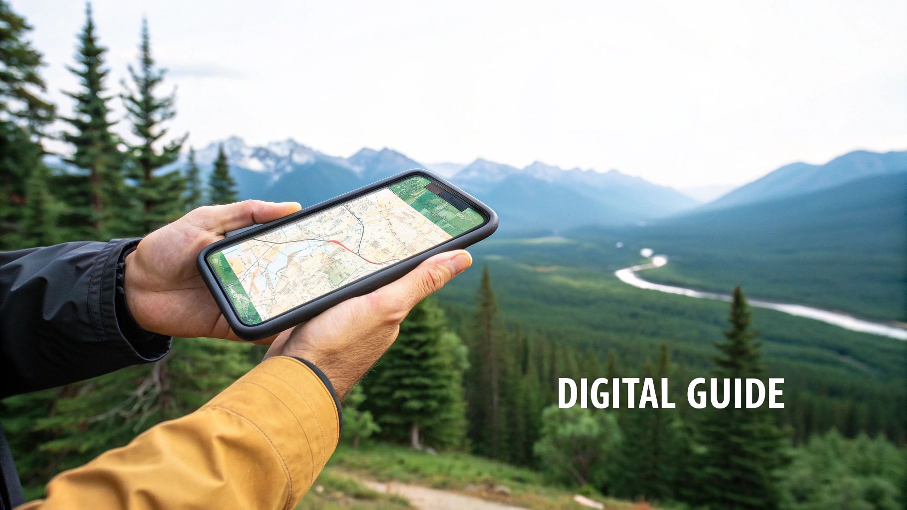
Choosing a digital partner for your hunt goes way beyond just picking a map. It’s about having a tool that keeps you safe, legal, and effective when you're out in the bush. The Canadian wilderness has its own set of rules and geographical quirks, and an app needs to understand that. Apps designed for American hunters just don't cut it; they almost always fall short on the detailed, province-specific data we need for a successful—and lawful—hunt north of the border.
This guide will give you an honest, side-by-side comparison of the top apps out there. We'll be judging them on the features that actually matter to us in Canada, from the B.C. Rockies to the dense forests of Ontario. My goal is to paint a clear picture of what works, what doesn’t, and why a Canadian-built solution is usually the way to go.
Understanding the Modern Canadian Hunter
The way we hunt in Canada is changing. Recent data shows that while fewer people are hunting, those of us who stick with it are more dedicated than ever and rely on better tools to make the most of our time. According to Statistics Canada, only 3% of Canadian households reported hunting near their homes in 2021, which is down from 4% in 2019. This trend makes it even more critical to use specialized apps that give you a real edge. You can dig into the numbers yourself on StatCan's findings.
This shift means we need apps that do more than just show you a map of the terrain. They have to make sense of complex data and serve it up in a simple, usable way.
A great hunting app doesn't just show you where you are; it tells you what you can legally do there. That distinction is the single most important factor for any hunter in Canada, where land access rules are complex and change dramatically from one province to the next.
Key Evaluation Criteria for Canadian Apps
To make a good choice, you need to know what to look for. We're going to compare the main contenders on a few non-negotiable features every Canadian hunter needs.
- Crown Land and Private Land Boundaries: Accuracy here is everything. We’ll look at how clearly each app shows different land types, including General Use Areas, so you don't accidentally end up where you shouldn't be.
- Wildlife Management Unit (WMU) Layers: A good app has to provide precise, easy-to-read WMU overlays. You should be able to see your unit instantly to confirm your season dates and tag eligibility. You can get familiar with how these digital WMU maps work.
- Offline Map Reliability: Cell service is a luxury in most of Canada's prime hunting country. Reliable, easy-to-download offline maps are a must-have for safety and navigation.
- Integrated Regulations and Seasons: The best apps pull provincial regulations right into the map, saving you the headache of flipping between government websites when you're in the field.
| Feature Comparison | US-Centric App (Typical) | Canada-Focused App (Ideal) |
|---|---|---|
| Crown Land Data | Often incomplete or missing entirely. | Detailed, accurate, and regularly updated. |
| WMU Boundaries | Might be inaccurate or use incorrect names. | Precise, with tap-to-identify functionality. |
| Regulations | Links out to general US fish and game sites. | Integrated, province-specific rules. |
| Offline Function | Basic map downloads. | Robust, with detailed layer saving. |
Essential Features for a Canadian Hunting App

Before we get into a side-by-side comparison, we need to talk about what makes a hunting app genuinely useful for us here in Canada. The best hunting apps Canada has on the market are more than just fancy digital maps. They’re built from the ground up to deal with our unique geography and complex regulations.
Knowing what to look for is the first step in telling the difference between a fun gadget and a piece of gear you can't live without. These are the non-negotiables.
Precise Land Access and Boundary Mapping
Knowing exactly where you stand is everything. The most critical job of any hunting app is to show you where you are, who owns the land, and what you’re legally allowed to do there. For Canadian hunters, that means crystal-clear, updated mapping of Crown Land, private property, and everything in between.
A top-notch app needs to do more than just show a boundary line. It has to differentiate between various types of Crown Land and clearly identify private parcels to keep you from accidentally trespassing. An app with blurry or old data is a liability, plain and simple. The best ones pull their information directly from provincial land registries and push updates regularly, so you can hunt confidently from southern Ontario farmland to the B.C. interior.
Accurate WMU and Provincial Regulation Data
Wildlife Management Units (WMUs) dictate almost everything we do as hunters in Canada. A good app should immediately tell you which WMU you're in the second you drop a pin on the map. There’s no room for guesswork here; this feature is absolutely essential.
But it goes beyond just knowing your WMU. The truly great apps bake the provincial hunting regulations right into the map. Imagine tapping your screen and instantly seeing the legal shooting hours, bag limits, and specific firearm restrictions for that exact spot, without ever leaving the app to dig through a 200-page government PDF.
The real power of a Canadian-focused app is its ability to connect your physical location to the specific set of rules that apply to that spot. It answers the question, "What can I legally hunt, right here, right now?"
When you're planning your season, you need to know precisely when your tag is valid in your chosen WMU. Having direct access to the official Canadian hunting season dates inside the app is a game-changer. It saves hours of research and helps you avoid a very expensive mistake.
Robust Offline Capabilities
Let's be honest: the best hunting often happens where there's zero cell signal. That fact alone makes reliable offline maps a must-have for both safety and navigation. A great app lets you download entire regions in advance—satellite imagery, topo lines, property boundaries, the whole package.
Once you're out there, those downloaded maps need to be 100% functional. You should be able to track your route with GPS, drop waypoints for a downed animal, and measure distances, all without a hint of a connection. All your saved spots, from a promising glassing knob to the location of your truck, have to be there when you need them. Without solid offline performance, an app is basically useless where it counts the most.
A Head-to-Head Look at the Top Apps for Canadian Hunters
Picking the right hunting app isn’t about app store ratings; it’s about what works on the ground, here in Canada. When we talk about the best hunting apps Canada has to offer, the real test is how they handle our unique landscape, from Crown Land boundaries in BC to the complex WMUs of Ontario.
We’re putting three of the biggest names under the microscope: HuntScout, onX Hunt, and GoHunt. This isn't about crowning a single winner. It's about figuring out which tool is right for your hunt. After all, a deer hunter in southern Ontario has a completely different set of needs than a moose hunter navigating the backcountry of northern Alberta.
Let's dive in.
Crown Land and Private Property Mapping
This is the bedrock of any Canadian hunting app. Getting this part wrong isn’t just an inconvenience—it can land you in serious legal trouble. An app's ability to clearly show you where you can and can't be is non-negotiable.
HuntScout You can tell HuntScout was built for Canada from the get-go. Its mapping is incredibly detailed, with clear, colour-coded layers that distinguish between different types of Crown Land, General Use Areas, and private parcels. The data comes straight from provincial land registries, which means you can trust it. Scouting a new spot in Ontario, for instance, you'll see not just the Crown Land border but also specific access restrictions noted right on the map. That’s a huge time-saver.
onX Hunt There's no denying onX is a giant in the US, but its Canadian data isn't always as sharp. It does a decent job showing general Crown Land boundaries, but it often lacks the fine-tuned detail you need. In a province like Alberta, with its patchwork of different land classifications, you might find yourself double-checking the app's info against a government source just to be sure. On the flip side, its private landowner information is often solid, which is a big help if you're looking to get permission.
GoHunt GoHunt's real strength is its deep well of research tools for the Western US, especially for hunters playing the draw odds game. Its Canadian mapping is functional but feels like a work in progress compared to the others. The land ownership layers are there, but they can feel a bit thin on detail and sometimes lag, particularly when you're off-grid. It’s a fine starting point, but probably not the tool you'd rely on for a complex hunt.
Think about it this way: a hunter in the Alberta foothills needs to know the difference between a grazing lease and a general-use Crown block. HuntScout shows you that distinction immediately. onX might just paint it all as one big piece of Crown Land, leaving you to do the homework on what specific access rules apply.
WMU Boundaries and Regulation Integration
Knowing your Wildlife Management Unit (WMU) is basic. But the best apps go a step further and pull provincial regulations right into the map. That simple feature turns your phone from a simple GPS into a powerful field guide.
HuntScout This is where HuntScout really pulls away from the pack. The WMU layers are more than just lines on a map—they’re interactive. Tap anywhere, and the app tells you the WMU you’re in and gives you a direct link to the official regulations for that specific zone. Better yet, its AI assistant can answer a question like, "What's the rifle season for whitetail in WMU 346?" This feature alone saves you from having to dig through those massive, confusing government PDFs.
onX Hunt onX gives you reliable WMU overlays for most of Canada. You can easily see which unit you're standing in, and the boundaries are usually spot-on. The weak point is the lack of deep regulation integration. It might link you to the main provincial hunting website, but it won’t take you to the specific page for your WMU. You still have to do the legwork of finding and reading the rules yourself.
GoHunt GoHunt's WMU layers are functional, but they’re more of a geographical reference than a regulatory tool. Just like onX, it helps you find your unit but doesn't connect the dots to the local rules. Its design is really geared toward unit-wide stats and draw odds, a system that’s far more relevant to hunters in the States.
To put this into perspective, we’ve created a quick comparison of how the top hunting apps handle Canada-specific features.
Canada-Specific Feature Comparison of Top Hunting Apps
This table breaks down how each app performs on the features that matter most to Canadian hunters—from the accuracy of our land maps to how well they work when you're miles from the nearest cell tower.
| Feature | HuntScout | onX Hunt | GoHunt |
|---|---|---|---|
| Crown Land Detail | Excellent. Highly detailed, colour-coded layers sourced from provincial data. | Good. General Crown boundaries are reliable, but lacks nuanced classifications. | Fair. Basic land ownership layers, but less detail than competitors. |
| WMU & Regs | Excellent. Interactive WMU layers with direct links and an AI assistant for specific rules. | Good. Accurate WMU boundaries but lacks deep, one-tap regulation integration. | Fair. Displays WMUs but offers minimal integration with provincial regulations. |
| Offline Maps | Excellent. Robust downloads with all Canadian-specific layers fully functional. | Excellent. Top-tier, reliable offline performance. A major strength of the platform. | Good. Solid offline functionality, though can be slower with very large map files. |
| Canada-First Focus | Yes. Built specifically for Canadian hunters, regulations, and land access systems. | No. An American app adapted for Canada; some data isn't as granular. | No. Primarily a research tool for the Western US with added Canadian maps. |
This side-by-side view makes it clear: while all are capable, some are simply better equipped for the unique challenges we face as Canadian hunters.
Offline Map Performance and Reliability
Here in the Canadian backcountry, cell service is a myth. Your app's offline mode isn't a bonus feature; it's a lifeline. The ability to save detailed maps and use every core function without a signal is absolutely essential.
HuntScout HuntScout’s offline mapping is rock-solid. You can download huge areas and keep every single layer—Crown Land, WMUs, satellite imagery, and topo lines. Once saved, all your tools like GPS tracking, waypoint marking, and measuring distances work perfectly. The download manager is straightforward, making it simple to get prepped for a week-long trip off the grid.
onX Hunt This is where onX has always shined. Its offline map system is trusted by countless hunters for a reason. It lets you download maps in different resolutions to save space, and all the crucial tools work flawlessly without a signal. For many, the sheer reliability of onX's offline mode is its biggest selling point.
GoHunt GoHunt also lets you save maps for offline use, and it generally works well. Some folks have noted that rendering very large, high-res map files can be a bit slower than the competition, but for most typical backcountry hunts, it gets the job done without any issues.
All three apps handle the basics of offline navigation. The real difference comes down to the quality and detail of the Canadian-specific layers you're able to save and use in the field.
The Bottom Line on Canadian Functionality
While all three of these apps are powerful, they were built with different priorities, and it shows.
HuntScout is, without a doubt, built for Canada first. Its unmatched Crown Land detail and seamless regulation integration make it the most efficient and trustworthy choice for navigating our country's distinct legal and geographical terrain.
onX Hunt remains a superb navigation tool. Its mapping engine is smooth and its offline performance is second to none. However, its Canadian data layers just aren't as deep, meaning you'll likely spend more time doing your own research outside the app.
GoHunt is a specialist's tool, and its specialty is planning hunts in the Western US. While its mapping features for Canada are improving, it currently trails the others in providing the detailed, on-the-ground data a Canadian hunter needs to feel confident.
For the hunter staring at a map of a complex regulatory zone or relying on a small sliver of Crown Land for access, the choice becomes pretty clear. The best app is the one that erases the guesswork and lets you focus on the hunt, not the rulebook.
Finding the Right App for Your Hunting Style
A features list on a website only tells you half the story. The real measure of a hunting app isn’t what it can do, but how well it performs when you’re out in the field, trying to make sense of Canadian hunting country. The best hunting apps Canada has to offer feel less like software and more like an essential piece of gear you wouldn't leave home without.
The key is to match the app to your specific style of hunting. A waterfowl hunter scouting prairie potholes has vastly different needs than a big-game hunter chasing elk through the mountains. Let’s break down which apps really shine in different Canadian hunting scenarios so you can find the right digital partner for your pursuit.
The Big-Game Hunter in Alberta
If you've ever hunted big game in Alberta, you know the landscape is a complex patchwork of Wildlife Management Units, grazing leases, and agricultural land. You need an app that provides flawless detail. For this kind of work, HuntScout is the clear front-runner. Its superpower is the ability to instantly show you the difference between various types of Crown Land and link you directly to the specific WMU regulations you're standing in.
Picture this: you're scouting for elk west of Calgary. Is that piece of bush a Forest Land Use Zone, a grazing lease with its own access rules, or private land? HuntScout lays it all out, taking the guesswork out of the equation and preventing a long walk back to the truck—or an awkward conversation with a game warden.
The Upland Bird Hunter in Ontario
For those chasing grouse and woodcock, the game is all about covering ground and exploring new coverts. Your success often comes down to one thing: finding accessible Crown Land quickly. The best app here is the one that makes spotting huntable public land dead simple.
This is where HuntScout excels. Its clean, colour-coded Crown Land layers are a game-changer. When you’re driving down logging roads in Northern Ontario, a quick glance at the screen shows you massive, accessible tracts of public land. You can make an on-the-fly decision about where to run the dogs next without fumbling with clunky government maps.
The decision for most Canadian hunters really comes down to one question: Do you need an app that was built from the ground up to understand our unique regulations and land access, or will a general North American map do the job?
This simple flowchart frames the choice perfectly.
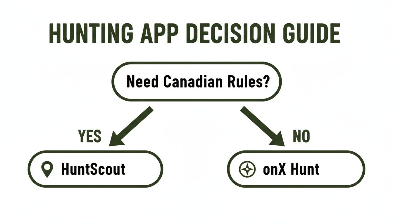
It highlights that if navigating Canada’s specific rules is your main priority, a specialized tool like HuntScout is built just for you.
The Waterfowl Specialist
Waterfowlers live on the edge—the edge of public and private land, that is. Whether you're hunting riverbanks, sloughs, or grain fields, knowing exactly where property lines are is non-negotiable. While the private landowner data in onX Hunt is undeniably a strong feature for getting permission on a field, HuntScout’s precise public water and Crown Land boundaries are just as critical for finding those hidden public spots.
When you're setting decoys on a river system, knowing the exact high-water mark that separates public access from private land is everything. HuntScout provides that clarity, so you can be confident your spread is set up legally.
The Backcountry Specialist
When you’re deep in the British Columbia mountains, miles from the nearest cell tower, your app stops being a convenience and becomes a vital piece of survival equipment. For the backcountry hunter, offline reliability is king. Both onX Hunt and HuntScout offer solid offline map capabilities.
The tiebreaker is the quality and depth of the offline data. HuntScout lets you save all of its detailed, Canada-specific layers—WMUs, Crown Land types, and more—for offline use. This means you have all the regulatory and geographic information you need, even when you're completely off the grid.
The New Hunter
Getting into hunting can feel like drinking from a firehose. The sheer volume of rules, seasons, and licenses is a lot to take in. A new hunter needs an app that acts as both a map and a mentor.
Here again, HuntScout is the superior choice for someone just starting out. Its built-in AI assistant and direct links to official regulations are a huge help. A new hunter can ask a simple question like, "When does archery season for deer open in my WMU?" and get an instant, reliable answer. This feature dramatically shortens the learning curve and helps build confidence.
As hunters get more skilled, they become more selective. The National Deer Association's 2026 report found that a record 46% of harvested bucks are 3½ years or older, a trend driven by hunters using better data to find mature animals. You can dig into the full 2026 NDA report to learn more.
Why HuntScout Excels for Canadian Hunters
After laying out the features side-by-side, one app consistently pulls ahead for Canadian hunters. While others are fantastic tools in their own right, HuntScout was clearly built from the ground up by Canadians, for Canadians. This isn't just a tagline; you can feel it in every feature, as it directly tackles the unique challenges we face out here.
Many other platforms try to retrofit their American systems for our market, and it often shows. The data can feel patched-in or just a little… off. HuntScout starts with our specific provincial rules and vast geography as its bedrock, making it arguably the most reliable hunting app Canada has for serious hunters.
A Tool Built for Our Rules
The biggest edge HuntScout offers is its seamless, intuitive handling of Canadian regulations. It solves the number one headache for hunters in any province: knowing exactly what’s legal, right where you’re standing. This is where the app’s design truly shines.
It doesn’t just draw a line on a map and call it a WMU. HuntScout makes that boundary come alive. A quick tap on your location instantly pulls up the unit details and gives you real, usable information.
- Instant WMU Identification: Forget toggling between your map and a clunky government PDF. The app tells you what zone you're in, right now.
- AI-Powered Regulation Assistant: This is a game-changer. You can literally ask it things in plain English, like, "What are the legal shooting hours for moose in this WMU?" and get a straight answer.
- Direct Provincial Links: If you're the type who likes to double-check (and we all should), the app provides direct links to the official provincial regulation documents for that specific zone. It saves so much time and hassle.
This relentless focus on regulatory clarity makes HuntScout more than just a map—it becomes an essential tool for staying compliant.
The real value of HuntScout is its ability to remove uncertainty. It closes the gap between knowing your location and understanding the rules that govern it, which is the most critical piece of information for any Canadian hunter.
Unmatched Mapping and Land Access Clarity
HuntScout's mapping capabilities are where it really separates itself from the pack, especially when it comes to Crown Land. While some competitors might just paint a generic “public land” layer, HuntScout delivers the fine-grained detail we actually need to navigate provinces with complicated land-use rules.
It clearly differentiates between types of Crown Land, like General Use Areas versus specific lease lands, which can have very different access rights. This kind of detail is absolutely vital in provinces like Alberta or British Columbia, where a wrong turn can quickly become a trespassing issue. It gives you the confidence to push into new territory, knowing you’re doing it legally and ethically.
Making the Switch to HuntScout
The idea of moving years of scouting data from another app can feel like a chore, but it’s actually pretty simple. Getting your waypoints—those hard-earned glassing spots, treestand locations, and kill sites—transferred over is the key to a smooth transition.
Here’s a quick guide to get it done:
- Export Your Data: Most apps, including onX Hunt, let you export your waypoints as a KML or GPX file. You'll usually find this option on their desktop or web platform.
- Import to HuntScout: Log into the HuntScout web app, find the import tool in your map menu, and upload the file you just downloaded.
- Organize and Sync: Your waypoints will pop up on your HuntScout map. From there, you can sort them into folders and make sure everything syncs to your phone for offline use.
Taking a few minutes to migrate your data means you can switch to a platform truly built for the way we hunt, without losing all that valuable intel. If you're ready for a tool designed specifically for our backyard, you can check out all the features on the official HuntScout website. It’s a small bit of effort upfront that pays off big time in the field.
Got Questions About Canadian Hunting Apps?
We've covered a lot of ground comparing the top hunting apps for Canadian hunters. By now, you've probably got a few questions buzzing around. Moving from paper maps to a digital tool is a big step, and it’s smart to think through the details. Let's tackle some of the most common questions I hear from fellow hunters to make sure you're ready to use your app with confidence.
These are the things you need to know before you head out.
Can I Actually Use an App to Navigate Crown Land Legally?
Yes, absolutely. Using an app to find and navigate Crown Land is one of the biggest reasons to have one in the first place. But here’s the critical part: the app is your guide, not a legal get-out-of-jail-free card. The responsibility to know where you are and to respect property lines is always on you, the hunter.
Think of it this way: a top-tier app like HuntScout gives you the best possible information by pulling data straight from provincial sources. It puts incredible accuracy right in your pocket.
At the end of the day, an app is a powerful tool for making the right call, but it doesn't replace your personal responsibility. You are always the one accountable for hunting ethically and within the law.
So, while the app will show you a boundary line with pinpoint precision, keep your eyes open. If you see a "No Trespassing" sign or a fence line in an area the map shows as Crown, use your judgment. The app gives you the data you need to stay legal, but it's up to you to use it wisely.
How Do Offline Maps Really Work? What’s the Catch?
For anyone hunting in Canada, offline maps aren't a luxury—they're a necessity. Good luck finding a cell signal in prime moose country. The concept is simple: before you lose service, you download a chunk of the map directly onto your phone.
This download saves everything you need for that specific area:
- Detailed satellite images
- Topographical lines to read the terrain
- Crown and private land boundaries
- Wildlife Management Unit (WMU) layers
- Any waypoints or tracks you've already marked
When you’re out in the bush, your phone's GPS chip talks to satellites to find your location—it doesn’t need a cell network to do this. That's how you can see your exact position on the map you saved, track your route, and drop a pin on a fresh scrape, all without a single bar of service.
The only real "catch" is storage space. High-resolution maps can be hefty files, so be smart about it. Download only the area for your upcoming trip and delete it when you're done. And, of course, make sure your phone is fully charged. Running the GPS all day will chew through your battery, so a power bank is always a good idea.
Are US-Based Hunting Apps Good Enough for Canadian Regulations?
This is the million-dollar question. Big American apps like onX Hunt are phenomenal tools for navigation and have great offline maps. No one can argue with that. But where they often stumble is with the nitty-gritty details of Canadian hunting regulations.
Their main game is the US market. As a result, their Canadian data—especially for complex regulations, season dates, and specific Crown Land designations—can be thin or outdated.
You end up in a situation where you know exactly which WMU you're standing in, but you still have to close the app and start digging through a clunky, 200-page government PDF to confirm if it's a bucks-only season or what the legal shooting light is.
This is precisely where a Canada-first app like HuntScout proves its worth. It builds that essential regulatory info right into the map. No more app-switching, no more guesswork. When you’re trying to stay legal in the Canadian wilderness, having a tool built for our rules just makes sense.
Ready to hunt with confidence and clarity? Download HuntScout today and experience the difference a truly Canadian-focused hunting app can make. Get detailed Crown Land maps, instant WMU information, and AI-powered regulation support right at your fingertips. Plan your next hunt at https://huntscout.app.

