Cell towers don't reach the best hunting spots. When you're ten miles deep in wilderness chasing that trophy buck, your fancy smartphone becomes a paperweight. This is why the best offline hunting maps remain essential gear for serious hunters who venture into remote areas where connectivity vanishes.
You'll learn about traditional paper topographic maps, dedicated GPS units, and mobile apps that function perfectly without cell service. We'll compare USGS maps, Garmin devices, OnX Hunt, HuntStand, and other proven navigation tools. By the end, you'll know exactly which offline mapping solution fits your hunting style and budget.
Traditional Paper Topographic Maps: USGS and National Geographic
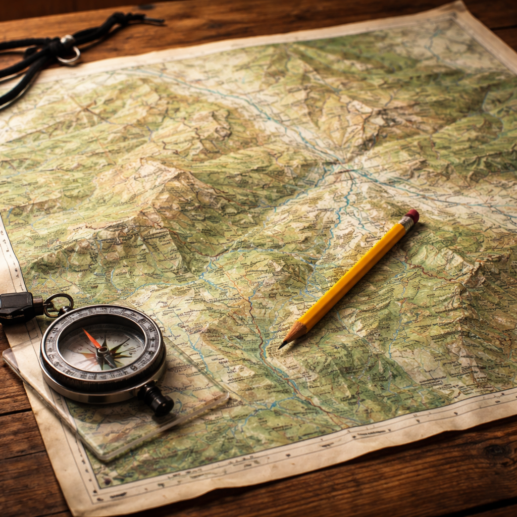
Paper maps never need batteries. They don't crack when dropped on rocks. Rain won't kill them if you store them properly. These simple facts make traditional topographic maps the most reliable backup navigation tool for remote hunting areas.
USGS 7.5-minute quadrangle maps remain the gold standard for detailed terrain information. Each map covers roughly 64 square miles at a 1:24,000 scale. That means one inch on the map equals 2,000 feet on the ground. You can spot every ridge, creek, and elevation change that matters for hunting.
The level of detail is incredible. Contour lines show elevation changes as small as 10 or 20 feet. You can identify saddles where deer travel, steep faces that hold elk, or gentle slopes perfect for a morning stalk. Water sources appear clearly marked. Old logging roads and trails show up even when they're not maintained anymore.
National Geographic produces excellent hunting maps for specific regions. Their Trails Illustrated series covers popular hunting destinations across the western United States. These maps use the same USGS data but add recreational information like trailheads, campgrounds, and hunting unit boundaries.
The biggest advantage of paper maps is their independence from technology. Digital maps depend on batteries and signals that can fail in remote areas, but paper maps work in any weather condition. They won't freeze in cold temperatures or overheat in desert conditions.
Paper maps do have limitations. They can't show your real-time position without a separate GPS device or compass work. They don't update when roads change or new trails get built. Weather can damage them if you don't protect them properly.
Smart hunters laminate their most important maps or store them in waterproof cases. You can write on laminated maps with dry-erase markers to mark stands, trails, or property boundaries. This makes them interactive tools for hunt planning.
Cost remains another major advantage. A single USGS quad map costs around $12-15. National Geographic maps run $15-20. Compare that to annual subscription fees for digital mapping services, and paper maps offer excellent long-term value.
The key is knowing which maps you need before your hunt. Study the area online first, then order the specific quadrangles that cover your hunting grounds. Don't wait until the last minute, as some maps take weeks to ship from the USGS store.
Garmin GPS Units: eTrex and GPSMAP Series
Dedicated GPS units solve the biggest problem with paper maps: showing your exact location. Garmin dominates this market with rugged devices built specifically for outdoor use. Their eTrex and GPSMAP series represent the best offline hunting maps technology available in handheld form.
The eTrex 32x offers the perfect entry point for hunters new to GPS navigation. It comes preloaded with a basic worldwide map, but you'll want to add detailed topographic maps for serious hunting. Garmin's TOPO U.S. 24K maps provide the same detail as USGS paper maps but with the added benefit of GPS positioning.
Battery life sets these units apart from smartphones. The eTrex 32x runs for 25 hours on two AA batteries. That's enough for a week-long hunting trip without worrying about power. The device also accepts standard alkaline, lithium, or rechargeable NiMH batteries.
The GPSMAP 66i takes things further with satellite communication features. It includes inReach technology for two-way messaging and SOS emergency beacons. This makes it ideal for solo hunters in extremely remote areas where even satellite phones don't work reliably.
Here's how the top Garmin hunting GPS units compare:
| Model | Battery Life | Screen Size | Satellite Communication | Price Range |
|---|---|---|---|---|
| eTrex 32x | 25 hours | 2.2 inches | No | $200-250 |
| GPSMAP 64sx | 16 hours | 2.6 inches | No | $300-350 |
| GPSMAP 66i | 35 hours | 3 inches | Yes (inReach) | $600-700 |
All these units work with Garmin's BaseCamp software for trip planning. You can create waypoints, routes, and tracks on your computer, then transfer them to your GPS. This lets you mark potential stand locations, property boundaries, or water sources before you even leave home.
The durability factor can't be overstated. These devices meet military standards for shock, water, and temperature resistance. They'll survive drops that would shatter a smartphone screen. The rubberized cases provide excellent grip even with wet or gloved hands.
Map storage works differently than smartphones. You can load multiple map regions onto a microSD card and swap them as needed. This approach ensures you always have detailed maps available without depending on cellular connections. A 32GB card can hold maps for entire states.
The learning curve is steeper than smartphone apps. The interface uses physical buttons instead of touchscreens, which works better with gloves but takes practice. Spend time with your GPS at home before relying on it in the field.
Garmin GPS units represent the best offline hunting maps solution for hunters who prioritize reliability and battery life over modern smartphone conveniences. They're purpose-built tools that excel in harsh conditions where other devices fail.
OnX Hunt: Premium Digital Hunting Maps
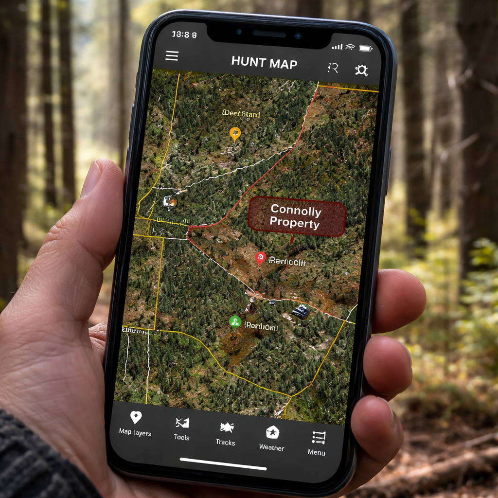
OnX Hunt revolutionized hunting with smartphone-based mapping that rivals dedicated GPS units. The app transforms your phone into a powerful navigation tool loaded with hunting-specific features that paper maps and basic GPS devices can't match.
The core strength lies in property boundary data. OnX Hunt shows precise public and private land boundaries with landowner names and contact information. This eliminates guesswork about where you can legally hunt. The boundaries are accurate to within 5-10 feet in most areas, based on official county records.
Offline functionality makes OnX Hunt one of the best offline hunting maps available on smartphones. You can download detailed maps of entire hunting areas before leaving home, ensuring full GPS navigation without cell service. The app continues working in airplane mode, preserving battery life while maintaining all mapping features.
The waypoint system excels for hunt planning and execution. You can drop custom pins for stand locations, trail cameras, scrapes, rubs, or any other important spots. The app offers nearly 100 different icons and color-coding options to organize your waypoints effectively.
Weather integration provides hyper-local forecasts that account for elevation and terrain features. This helps predict wind patterns, temperature changes, and precipitation that affect animal movement. The wind forecast feature is particularly valuable for planning approach routes to stands.
OnX Hunt includes specialized layers that traditional maps lack entirely. The app shows hunting unit boundaries, seasons, and regulations for your exact location. It displays walk-in hunting areas, wildlife management areas, and other public access points that aren't marked on standard topographic maps.
The subscription model offers different tiers based on coverage area. Premium plans cost $34.99 annually for single states or $49.99 for two-state access. Elite membership runs $99.99 per year but includes all 50 states plus Canada, along with advanced features like trail camera analysis and recent satellite imagery.
Recent satellite imagery updates every two weeks in Elite subscriptions. This shows current conditions like logging activity, crop harvests, or burned areas that affect animal patterns. The imagery accuracy helps hunters adapt their strategies based on changing habitat conditions.
Sharing capabilities let hunting partners coordinate effectively. You can share waypoints, tracks, and routes with other OnX Hunt users. The offline sharing feature works even without cell service, using Bluetooth or WiFi direct connections.
Battery management becomes crucial when using smartphones for navigation. OnX Hunt includes power-saving modes that extend battery life. However, you'll still need portable battery packs for multi-day hunts. The app recommends keeping your phone in airplane mode and only activating the screen when checking your position.
The 3D mapping feature helps visualize terrain in ways that contour lines can't match. You can examine ridges, valleys, and potential travel corridors from different angles. This perspective helps identify funnels and pinch points that concentrate animal movement.
OnX Hunt represents the evolution of hunting maps from static references to dynamic, interactive tools. It combines the best aspects of traditional topographic maps with modern GPS technology and hunting-specific data layers that serious hunters demand.
HuntStand and BaseMap: Mobile App Alternatives
OnX Hunt isn't the only game in town for smartphone-based hunting maps. HuntStand and BaseMap offer compelling alternatives with different strengths and pricing models. These apps prove that hunters have multiple options for the best offline hunting maps on mobile devices.
HuntStand takes a social approach to hunting maps. The app includes community features where hunters can share information about public land access, recent animal sightings, and hunting pressure levels. This crowdsourced data adds value beyond what traditional maps provide.
The free version of HuntStand includes basic mapping features with limited offline capability. The premium subscription unlocks full offline maps, property boundaries, and advanced weather forecasting. At $9.99 monthly or $99.99 annually, it costs more than OnX Hunt but includes some unique features.
HuntStand's hunting journal integrates directly with the mapping system. You can log hunts, track weather conditions, and record animal observations tied to specific GPS locations. Over time, this creates a detailed database of hunting patterns and success factors.
BaseMap focuses on simplicity and ease of use. The interface feels more intuitive than OnX Hunt for hunters who aren't tech-savvy. The app emphasizes core mapping features without overwhelming users with complex layers and options.
Property boundaries in BaseMap come from the same county records as other apps, but the display is cleaner and easier to read. The app uses bold colors and clear labels that work well on smaller phone screens. This makes it easier to identify boundaries quickly while hunting.
Offline functionality in BaseMap works similarly to OnX Hunt. You download map areas before hunting, then use GPS positioning without cell service. The app includes detailed topographic data and satellite imagery for most hunting areas across North America.
BaseMap's pricing structure differs from competitors. Instead of annual subscriptions, you can purchase individual state maps for one-time fees ranging from $29.99 to $49.99. This appeals to hunters who focus on specific areas rather than traveling across multiple states.
Both apps work with external GPS devices for improved accuracy. You can connect Bluetooth-enabled GPS receivers that provide better positioning than phone-based GPS alone. This hybrid approach combines smartphone convenience with dedicated GPS precision.
Battery life remains a concern with all smartphone-based mapping apps. HuntStand and BaseMap both include power management features, but you'll still need backup power sources for extended hunts. Consider portable battery packs rated for at least 10,000mAh capacity.
The choice between these apps often comes down to specific features and pricing preferences. OnX Hunt offers the most comprehensive feature set but costs more. HuntStand adds social features that some hunters value. BaseMap provides simplicity and one-time purchase options.
All three apps represent significant improvements over paper maps for active navigation while maintaining offline capability. They transform smartphones into powerful hunting tools that work reliably in remote areas where the best hunting happens.
Atlas and Gazetteer Series: State-Specific Hunting References
DeLorme's Atlas and Gazetteer series fills the gap between large-scale USGS maps and basic road atlases. These spiral-bound books provide detailed topographic coverage for entire states in a format that's perfect for vehicle-based hunting and trip planning.
Each atlas uses a consistent 1:150,000 scale that shows much more detail than standard road maps but covers larger areas than individual USGS quadrangles. You can see elevation contours, water bodies, forest cover, and road networks all in one view. This makes them ideal for identifying potential hunting areas and planning access routes.
The spiral binding lets you fold the atlas to show your specific area without fighting with unwieldy paper. The books fit easily in glove compartments or day packs. Pages use heavy paper stock that resists tearing and moisture better than standard map paper.
Public land identification is a key strength of these atlases. They clearly mark state forests, national forests, wildlife management areas, and other huntable public lands. Different colors and patterns make it easy to distinguish between land ownership types at a glance.
Gazetteer sections in the back of each atlas provide detailed indexes of geographic features. You can quickly locate specific lakes, mountains, or towns using grid coordinates. This saves time when trying to find unfamiliar areas mentioned in hunting reports or regulations.
Road classifications help with access planning. The atlases show everything from interstate highways down to seasonal logging roads. Different line weights and colors indicate road quality and seasonal access restrictions. This prevents surprises when you discover that "road" on your map is actually an impassable two-track.
Campground and boat launch symbols mark important access points for hunting areas. The atlases include both public and private facilities, though you should verify current status and fees before relying on this information.
State-specific hunting regulations often reference geographic features shown in these atlases. Having the same reference maps that wildlife agencies use makes it easier to understand boundary descriptions and access regulations.
The atlases cost between $20-30 per state, making them affordable references for serious hunters. They don't replace detailed topographic maps for precision navigation, but they excel for trip planning and general area orientation.
Updates come out every few years to reflect road changes, new developments, and updated public land boundaries. Check publication dates when buying used copies, as outdated information can lead to access problems or trespassing issues.
These atlases work best in combination with other mapping tools. Use them for initial area selection and route planning, then switch to detailed USGS maps or GPS units for precise navigation in the field. The different scales complement each other perfectly for comprehensive hunting trip preparation.
Offline Map Preparation: Tips for Remote Hunting Success
The best offline hunting maps are useless if you don't prepare them properly before heading into remote areas. Successful hunters develop systematic approaches to map preparation that ensure reliable navigation regardless of weather, equipment failures, or unexpected situations.
Start your preparation by identifying all the maps you'll need for your hunting area. This includes detailed topographic maps for your primary hunting zones, broader-scale maps for travel routes, and backup maps for adjacent areas in case you need to change plans. Don't rely on a single map type or source.
Download digital maps well before your hunting trip. Internet connections at remote trailheads are often slow or nonexistent. Test your downloaded maps by turning on airplane mode and verifying that all features work correctly. This includes waypoints, property boundaries, and elevation data.
Create redundant navigation systems. Carry paper maps as backups to GPS devices. Bring extra batteries for electronic equipment. Pack a quality compass and know how to use it with your maps. Equipment failures happen at the worst possible times, and redundancy saves hunts.
Mark critical waypoints before leaving home. These include your vehicle location, camp sites, water sources, known property boundaries, and emergency exit routes. Use descriptive names and consistent color coding so you can quickly identify waypoints in stressful situations.
Practice using your navigation tools in familiar areas before depending on them in remote locations. Learn the interface quirks of your GPS unit or smartphone app. Practice basic compass navigation techniques. Muscle memory matters when you're cold, tired, or stressed in the field.
Waterproof protection is essential for all maps and devices. Use quality map cases or dry bags rated for complete submersion. Even "waterproof" electronics can fail when subjected to heavy rain or stream crossings. Proper protection ensures your navigation tools remain functional throughout your hunt.
Battery management strategies become critical for electronic devices. Carry spare batteries in waterproof containers. Use lithium batteries in cold weather for better performance. Consider portable solar chargers for extended trips. Turn off unnecessary features like Bluetooth or WiFi to extend battery life.
Plan your route with multiple exit strategies. Mark alternate routes back to your vehicle or main trail in case your primary route becomes blocked or dangerous. Share your planned route with someone reliable who can initiate rescue procedures if you don't return on schedule.
Study local regulations and boundary descriptions before your hunt. Print copies of relevant hunting regulations and property boundary descriptions. Some legal boundaries follow geographic features that aren't obvious on maps, like the "third ridge west of Miller Creek" or "the old logging road to the abandoned homestead."
Test your emergency communication plan. If you carry a satellite communicator, verify that it works in your hunting area. Program emergency contacts and practice sending messages. Know the limitations of your communication devices and have backup plans if they fail.
The best offline hunting maps require preparation, redundancy, and practice to use effectively. Hunters who invest time in proper preparation rarely get lost or face navigation emergencies, even in the most remote areas where the biggest trophies live.
Frequently Asked Questions
What are the most reliable offline hunting maps for areas with no cell service?
USGS topographic maps and dedicated GPS units like Garmin eTrex series offer the most reliable offline navigation. Paper maps never need batteries or worry about electronic failures, while GPS units provide precise positioning with 15-25 hour battery life. OnX Hunt and similar apps work well offline too, but require more frequent charging and backup power sources for extended hunts.
How do I download maps for offline use in hunting apps?
Most hunting apps like OnX Hunt, HuntStand, and BaseMap include offline download features. Open the app's map section, select "Offline Maps" or "Download Maps," then choose your hunting area and resolution level. Download maps before leaving home using WiFi to avoid data charges. Test downloaded maps by switching to airplane mode and verifying all features work properly.
Which GPS unit offers the best battery life for multi-day hunting trips?
The Garmin GPSMAP 66i provides up to 35 hours of battery life on a single charge, making it ideal for extended hunts. The eTrex 32x runs for 25 hours on two AA batteries, with the advantage of easy battery replacement in the field. Both units accept lithium batteries for even better cold-weather performance during late-season hunts.
Are smartphone apps as accurate as dedicated GPS units for hunting navigation?
Modern smartphones with GPS chips provide similar accuracy to dedicated units, typically within 3-5 meters under good satellite conditions. However, dedicated GPS units often receive signals better in heavy cover and maintain accuracy longer as batteries drain. The best offline hunting maps strategy combines both: use smartphone apps for detailed planning and GPS units for critical navigation in challenging conditions.
How much do quality offline hunting maps cost annually?
Paper USGS maps cost $12-15 each and last indefinitely with proper care. OnX Hunt subscriptions run $35-100 annually depending on coverage area and features. Garmin GPS units cost $200-700 upfront plus $50-100 for detailed map sets, but have no recurring fees. BaseMap offers one-time state purchases for $30-50, making it cost-effective for hunters focused on specific areas.
What backup navigation should I carry besides my primary maps?
Always carry a quality compass and know basic triangulation techniques using topographic features. Pack paper maps of your hunting area even if you primarily use electronic devices. Bring extra batteries in waterproof containers, and consider a backup GPS device or smartphone with downloaded maps. The best offline hunting maps strategy includes multiple independent navigation methods that don't share common failure points.
Can I use hunting apps without paying for premium subscriptions?
Most hunting apps offer free versions with basic mapping features, but offline capability usually requires paid subscriptions. Free versions typically limit map downloads, don't show property boundaries, and lack hunting-specific layers. For serious remote hunting, premium subscriptions provide essential features like detailed offline maps, landowner information, and hunting unit boundaries that justify the annual cost.
How do I protect maps and GPS devices from weather damage?
Use waterproof cases rated for complete submersion, not just "water-resistant" protection. Quality dry bags or hard cases from companies like Pelican or Otterbox provide reliable protection. For paper maps, lamination or waterproof map cases allow use in rain while preventing damage. Store electronic devices in protective cases when not in use, and always carry backup navigation tools in separate waterproof containers.
Conclusion
The best offline hunting maps combine reliability, accuracy, and ease of use for remote areas where cell service disappears. Paper USGS topographic maps provide unbeatable reliability and never need batteries, making them essential backup navigation tools. Dedicated GPS units like Garmin's eTrex and GPSMAP series offer precise positioning with exceptional battery life, perfect for multi-day hunts in harsh conditions.
Smartphone apps like OnX Hunt, HuntStand, and BaseMap transform mobile devices into powerful hunting tools with property boundaries, weather data, and hunting-specific layers. These apps excel at trip planning and provide detailed information that traditional maps can't match, but they require careful battery management and backup power sources.
The smartest approach uses multiple navigation methods that complement each other's strengths. Start with smartphone apps for detailed planning and current information. Carry a dedicated GPS unit for reliable positioning in challenging conditions. Always pack paper maps and a compass as fail-safe backups that work regardless of weather or equipment failures.
Success in remote hunting areas depends on thorough preparation before leaving home. Download offline maps, mark critical waypoints, test all equipment, and practice using your navigation tools in familiar areas. The hunters who invest time in proper map preparation rarely face navigation emergencies, even in the most remote wilderness areas.
Remember that the best offline hunting maps are the ones you know how to use confidently. Whether you choose paper maps, GPS units, or smartphone apps, spend time learning their features and limitations. Your navigation skills matter more than the specific tools you carry, and proper preparation ensures safe, successful hunts in the places where the biggest trophies live.

