Finding the right spot to hunt can feel like a puzzle. Most hunters waste hours chasing rumors that turn out to be dead ends. This guide shows you exactly how to find private hunting land maps so you can plan fast, stay legal, and spend more time in the field. We’ll walk you through free sites, county GIS tools, online forums, and the final ownership check. By the end you’ll have a repeatable process you can use on every hunt.
Step 1: Identify Public Resources and Online Map Portals
Public agencies often publish free map layers that show who owns what. When you know how to find private hunting land maps, you start with the big picture and narrow down to the exact parcel.
One of the easiest places to start is the Bureau of Land Management’s map portal. The BLM posts a national viewer that lets you toggle public and private layers, see satellite images, and download PDFs. Check out the BLM Maps page for a quick start.
And the viewer isn’t just for the West. It includes Alaska, Florida, and many other states. You can zoom right down to a county level and see the outline of each tract.
Another handy trick is to look for state‑specific portals that pull the BLM data into a local view. Many states host a “National Data” viewer that mirrors the federal site but adds extra layers like road access points. A quick Google search for “state land map viewer” usually lands you on the right page.
When you pull up the map, turn on these layers:
- Public land boundaries , usually shown in green.
- Private parcel outlines , often in red or black.
- Road and trail networks , helps you plan a legal entry.
And remember to note the map’s date stamp. Land ownership can change, so you want the newest version.
Once you have the basic view, you can start marking spots that look promising. Look for clearings, water, and any old logging roads that cut through the public area. Those are the spots hunters love.
For a deeper dive into the BLM viewer tools, see the official BLM maps site again. It walks you through layer toggles, download options, and print‑ready PDFs.
Step 2: Use County GIS and Land Record Systems
County GIS portals give you the most detailed view of land parcels. When you master how to find private hunting land maps at the county level, you can verify exact ownership and any easements.
The Texas General Land Office runs a strong GIS hub. Their site lets you pull up the Land and Lease Mapping Viewer, which shows original survey lines, lease areas, and up‑to‑date aerial imagery. Check the Texas GLO GIS page for the viewer.
But Texas isn’t the only place with great data. New Mexico’s State Land Office also offers an interactive hunting‑access map that flags public trust lands, private easements, and water points. See the NM State Lands hunting access page for the map tool.
Here’s a quick step‑by‑step on using a county GIS:
- Open the GIS viewer and locate your county.
- Turn on the “Parcel” layer to see every legal boundary.
- Activate the “Aerial Imagery” layer for real‑world context.
- Use the “Identify” tool to click on a parcel and read the owner’s name, tax ID, and any recorded easements.
- Export the parcel as a KML or PDF for later use.
Why this matters: The GIS data is the official record. If you later need to prove you had permission, the GIS printout is solid evidence.
And you can cross‑reference the GIS data with the public maps you gathered in Step 1. If the two sources line up, you’ve got a reliable spot.
Below is a comparison table that helps you decide which GIS tool fits your needs.
| Feature | Texas GLO GIS | NM State Lands GIS |
|---|---|---|
| Survey accuracy | High , uses state‑verified grids | Moderate , combines state and federal data |
| Ease of use | User‑friendly with tutorials | More technical, but detailed |
| Export options | KML, PDF, shapefile | PDF, CSV |
| Access to lease info | Full lease layer available | Limited lease info |
And remember to check the date on each GIS layer. Some counties update quarterly, others yearly.
Now that you have the exact parcel data, you can move to the next step: hunting forums and private sellers.
For more on how to find private hunting land maps using official state tools, see How to Find Crown Land Ontario A Complete Guide | HuntScout. It gives a solid example of using both public portals and a hunting app.
Step 3: Use Hunting Forums, Clubs, and Private Map Sellers
Online communities are gold mines for private hunting land maps that aren’t posted on government sites. Hunters share tips, sell custom maps, and even offer access deals.
One of the most popular platforms is onX Hunt. Their web app lets members upload custom waypoints, share land‑ownership layers, and download maps for offline use. Start by signing up for a free trial and explore the public land view. See the onX Hunt app page for details.
And the app isn’t just for public land. Many private owners upload their own parcel outlines, complete with tax addresses and contact info. That makes it easy to reach out for permission.
Another tip is to join regional hunting forums on sites like Reddit, Facebook groups, or dedicated hunting boards. Search for “private land maps” plus your state name. Experienced hunters often post PDFs or screenshots of their own GIS pulls.
But keep in mind the quality of user‑generated maps can vary. Always cross‑check a community map with an official GIS source before you trust it.
When you find a map that looks good, download it and open it in a free viewer like QGIS. That lets you add extra layers, such as elevation or water sources, to make a more complete hunting plan.
And if you’re ready to buy a ready‑made map, many private sellers offer printable PDFs that include property lines, access roads, and even recommended hunting stands. Look for sellers that list the data source , they should say something like “derived from county GIS 2025”.
Here’s a quick checklist for vetting a private map seller:
- Ask for the data source (county GIS, state GIS, or reputable app).
- Verify the map’s date , newer is better.
- Check if the seller includes a disclaimer about ownership changes.
- Make sure the map shows both public and private boundaries.
And if you need a professional survey to be absolutely sure, the UK‑based Home - South Surveyors offer certified surveys that can confirm exact property lines for any parcel.
Step 4: Verify Ownership, Access Rights, and Map Accuracy
The final piece of how to find private hunting land maps is to double‑check that you can actually step onto the land. This step saves you from fines and broken relationships.
Start by pulling the parcel’s ownership record from the county assessor’s website. Most counties let you search by parcel number or address and will list the owner’s name, mailing address, and any recorded easements.
Next, compare the assessor’s data with the GIS layer you saved earlier. If the boundaries line up, you have a solid picture of where the land sits.
Then reach out to the landowner. A polite email or phone call that references the exact parcel number and shows you’ve done your homework usually gets a response. Offer to leave a “thank you” note or a small gift if they grant you access.
And always ask for written permission. Even a simple email that says “you may access parcel XYZ on this date” protects you if a dispute arises.
When you have permission, mark the legal access points on your map. Use the onX app or any GPS tool to set waypoints for the gate, the trail, and any water crossings.
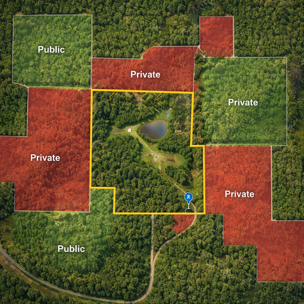
Below is a quick visual of what a verified map looks like.
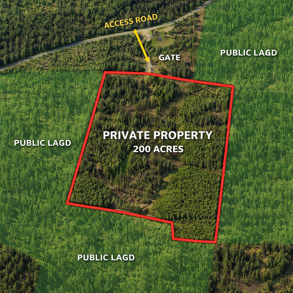
Finally, run a quick field test. Drive to the edge of the parcel, pull up your offline map, and make sure the GPS dot stays inside the green area. If it drifts onto red, you’re on private land without permission.
For hunters who want a quick way to list or lease their own land, the Property Copilot | The Trusted Rental Management Platform for Canadian Landlords & Tenants site lets owners post hunting leases and manage inquiries.
If you need water access to reach a parcel, a reliable boat can make a big difference. Check out Buying a Pontoon Boat OK: 7 Essential Tips for Choosing the Right Vessel for advice on picking a boat that works for lake‑side hunts.
Conclusion
Knowing how to find private hunting land maps turns a guess‑work hunt into a science. You start with free public portals, drill down with county GIS, tap into community knowledge, and finish with a solid ownership check. Each step adds confidence and cuts down on wasted trips.
Use the BLM viewer for a national overview, the Texas GLO or NM State Lands GIS for exact parcels, and onX Hunt for custom layers. Always verify the owner and get written permission before you step foot on the ground. When you follow this roadmap, you’ll spend more time tracking game and less time worrying about trespass.
Ready to put the plan into action? Grab a map, call the landowner, and hit the trail with a clear, legal path. Happy hunting!
FAQ
How can I quickly locate private hunting land maps for a new state?
Start with the BLM national map viewer, then look for the state’s GIS portal. Most states link their GIS from the land‑management department site. After you find the parcel layer, use the identify tool to pull up ownership info. Cross‑check that data with the county assessor website and you’ll have a reliable map in under an hour.
What should I do if the GIS data and the county assessor record don’t match?
Discrepancies happen when parcels are sold recently. First, note the date stamps on both sources. If the GIS layer is older, trust the assessor’s newer record. Call the county clerk for clarification, or request a recent certified survey. Until you get confirmation, treat the land as private and seek permission.
Can I use a hunting app instead of official GIS sites?
Yes, many hunters rely on apps like onX Hunt for a fast view of land boundaries. The app pulls data from official GIS sources, but you should still verify critical parcels with the county’s website. The app shines when you need offline maps and real‑time GPS while in the field.
How do I ask a landowner for access without sounding pushy?
Be clear, polite, and specific. Mention the exact parcel number, the dates you plan to hunt, and how you’ll respect the land (stay on roads, close gates, no ATVs unless allowed). Offer to share a small portion of your harvest or help with a task on the property. Written permission, even an email, is best.
What are the biggest legal risks if I hunt without confirming ownership?
Hunting on land you don’t own can lead to trespassing charges, fines, and loss of hunting privileges. In some states, repeat offenses can result in a ban from public land. Always double‑check ownership and get written permission to keep your record clean.
Is it worth paying for a professional land survey?
A professional survey gives you a legal document that shows exact boundaries. If you plan to hunt the same parcel season after season, a survey can save you time and avoid disputes. It’s especially useful for large tracts or areas with complex easements.

