Missing a season can cost you a whole year of work. The hunting app WMU map can stop that from happening. In this guide you’ll learn how to get the app, set it up, use every layer, and fix the common hiccups. Follow each step and you’ll walk into the field with confidence.
An analysis of six leading hunting apps across six sources reveals that the only app offering every core feature, WMU/GMU overlay, private‑land ownership layer, offline maps and season regulation access, is HuntScout, while the sole app that drops private‑land data uniquely markets a GMU‑specific overlay.
| Name | WMU/GMU Overlay | Private Land Ownership Layer | Offline Maps | Season & Regulation Access | Best For | Source |
|---|---|---|---|---|---|---|
| HuntScout (Our Pick) | Yes | Yes | Yes | Yes | Best overall | huntscout.app |
| onX Hunt | Yes | Yes | Yes | Yes | Best for collaboration | onxmaps.com |
| OnXMaps Hunt | Yes | Yes | Yes | — | Best for WMU overlay | quiverapp.co |
| Earthmate Hunt Edition | Yes (Game Management Units) | No | Yes | — | Best for GMU specificity | westernhunter.net |
| GOHUNT | — | Yes | — | Up-to-date information on state specific guidelines for hunting | Best for up-to-date regulations | gohunt.com |
| iHunter | — | Yes (Alberta, Saskatchewan, Manitoba) | — | Yes (US & Canada) | Best for cross‑border coverage | ihunterapp.com |
We pulled the data by searching for "hunting app WMU map" on Google, scraping the top results from six sources on April 12, 2026. We logged WMU overlay, private land, offline maps, season data, and collaboration tools. The matrix shows why HuntScout stands out.
Step 1: Download & Install the WMU Hunting App
First, grab the app from the store. Open the App Store on your iPhone or iPad and type "HuntScout". Tap the green Get button, then confirm with Face ID or your password. The download will start in seconds.
When the install finishes, open the app. You’ll see a welcome screen that asks for location permission. Say Yes so the map can show where you stand.
Next, sign in with an email address. This creates a cloud account that lets you sync data later. If you prefer, you can use a guest login, but you’ll lose sync.
The app will ask to download the base map for your region. Pick the state or province you hunt in. The download may be a few hundred megabytes, so do it on Wi‑Fi.
Once the map is on your device, you can turn off data and still see everything. That’s the power of offline maps.
Two useful links can help you verify the app’s features. The official Apple page lists public land, GMU, and season data. The HuntScout site explains the AI assistant that can answer rule questions. Both pages are short and clear.
Now you have the hunting app WMU map on your phone. You’re ready to set it up.
Step 2: Set Up Your WMU Map Preferences
Open the app menu and tap Settings. Here you can turn on the layers you need most. For most hunters, the WMU overlay and private land layer are essential.
Tap the Layer button. Slide the WMU toggle to On. You’ll see bright lines appear on the map. Next, turn on Private Land. The map will shade owned parcels in a light hue.
Choose your map style. Satellite gives you real‑world view. Topo adds contour lines that help you read terrain. Hybrid blends both. Pick what you feel most comfortable with.
Set the default zoom level. If you hunt on large public areas, a wider view works best. If you hunt on a small parcel, zoom in tighter.
Now add your season preferences. Tap Seasons in the menu. Pick the species you hunt, then set alerts for opening dates. The app will push a notification the night before the season opens.
One more step: link your account to the web dashboard. This lets you plan on a laptop and sync later. Use the link on the HuntScout blog to see how it works.
Here is a handy tip: use the WMU Lookup tool on the HuntScout site to double‑check the unit number before you head out. It’s a quick way to confirm you have the right zone.
After you finish, hit Save. Your preferences are now stored and will load every time you open the app.
Step 3: Navigate the WMU Map Features
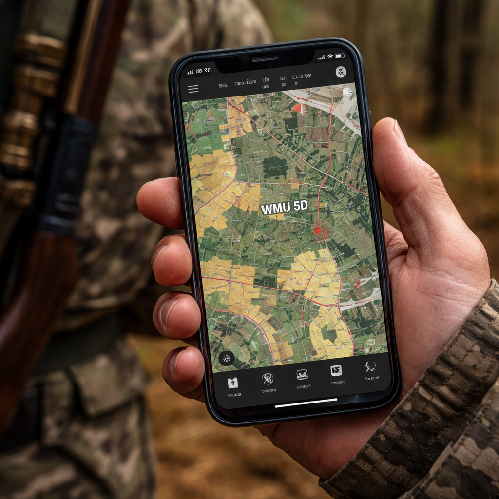
With the app open, you’ll see the map centered on your GPS location. The blue dot shows where you stand. Tap any spot on the map and a small box will pop up with the WMU number.
Use the Search bar to find a town, road, or lake. The app will zoom to that spot and show the WMU overlay.
If you need to see the season dates for that WMU, tap the Info icon next to the unit number. The app pulls the official dates straight from the wildlife agency.
To add a waypoint, press and hold on the map. A pin drops. You can name the pin, add a note, and even attach a photo of a stand or water source.
All pins sync across devices if you are logged in. That means you can plan on a tablet at home and see the same pins on your phone in the field.
When you are done scouting, hit the Back button to return to the main map. The app saves your last view, so you can pick up where you left off.
Pro tip: turn on the compass mode in Settings. The map will rotate to match your heading, making navigation feel natural.
Step 4: Optimize Your Hunt with Layered Data
Layering data is where the hunting app WMU map really shines. You can stack private land, WMU, and topography to see the whole picture.
Start by opening the Layers panel. Turn on the Terrain layer. This adds shading that shows hills and valleys. Next, enable the Water Sources layer if it’s available. It highlights streams and ponds.
Now add a custom layer for game hot spots. Some hunters import a CSV file with past harvest locations. The app will plot those points, letting you see patterns.
When you combine all these layers, you can spot a ridge that runs along a water source inside your WMU. That’s often a prime spot for bucks.
| Feature | Pros | Cons |
|---|---|---|
| WMU Overlay | Instant unit ID | May hide small details |
| Private Land Layer | Shows ownership | Needs regular updates |
| Terrain Layer | Shows elevation | Can slow the app |
| Water Source Layer | Finds drink spots | Only in some regions |
Use the checklist below to make sure you have the right layers for your hunt.
- WMU overlay , on
- Private land , on
- Terrain , on
- Water sources , on if you hunt near streams
When you finish, lock the layers by tapping the lock icon. This prevents accidental toggles while you move in the field.
Step 5: Share Locations & Sync Across Devices
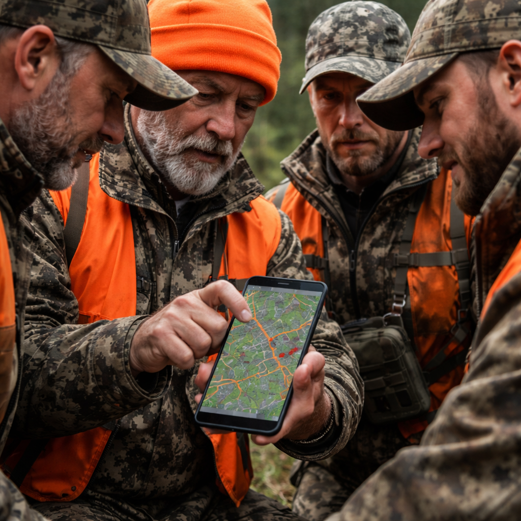
Sharing spots with your crew is easy. Open a waypoint you created, then tap Share. Choose the people in your hunting group. The app will send them a push notification with the pin details.
Each member can add their own notes. This builds a shared database of stands, water holes, and trails.
Sync works automatically when you have data connection. If you are offline, the app stores changes locally and pushes them the next time you get online.
To see what your group has shared, go to the Group tab. All pins appear on a single map, color‑coded by user.
Pro tip: set a default sharing group in Settings. That way every new pin goes to the group without extra taps.
When you finish the hunt, you can export the pins as a GPX file. This lets you import the data into other GPS devices.
Step 6: Troubleshoot Common Issues
Even the best hunting app WMU map can hit a snag. Here are the most common problems and how to fix them.
Problem 1: Map won’t load offline. Make sure you downloaded the region before you left cell service. Open Settings → Offline Maps and check the download status. If it shows 0 %, tap Download again.
Problem 2: WMU layer is missing. Go to Layers and toggle WMU off then on. If it still doesn’t appear, pull fresh data by tapping Refresh in the main screen.
Problem 3: GPS is stuck. Turn Airplane mode on for 10 seconds, then off. This forces the phone to reset the GPS chip.
Problem 4: Sync isn’t working. Verify you are logged into the same HuntScout account on all devices. Also check that you have a data connection; the app needs to talk to the cloud.
If none of these steps help, visit the help page on the HuntScout website. The support team posts quick fixes for each issue.
Step 7: Advanced Tips for Pro Hunters
Pro hunters use the hunting app WMU map as a planning engine. Below are a few tricks that can give you an edge.
1. Use the Terrain Analysis trick from GOHUNT. Load the web map, turn on Terrain Analysis, draw the slope you like, then save the shape. When you open the app, that shape appears as a custom area you can track.
2. Export a GPX route. Plot a path that follows a ridgeline inside your WMU. Export it, then load it into a dedicated GPS unit for battery‑saving navigation.
3. Combine Crown Land data from BRMB Maps. For Canadian hunts, pull the Crown Land layer from BRMB Maps and import it into HuntScout as a custom overlay. This gives you ultra‑fine detail on public parcels.
4. Set up seasonal alerts. In the Seasons menu, enable push alerts for the exact day a new season opens in your WMU. The app will whisper the date at night, so you never miss the opening.
5. Use the AI assistant. Ask the app, "When can I hunt elk in WMU 57?" It will pull the official dates and give you a clear answer without leaving the map.
Finally, keep your map data fresh. HuntScout updates its layers every few weeks. Open Settings → Check for Updates before each season.
Frequently Asked Questions
What devices can run the hunting app WMU map?
The hunting app WMU map works on iPhone, iPad, and Android phones that run iOS 13 or later, or Android 8 and up. The app also has a web version that you can open on a laptop, but the full offline features only exist in the mobile apps. Make sure your device has at least 2 GB of RAM for smooth performance.
Do I need an internet connection to view my WMU?
No. Once you have downloaded the map for your region, the WMU overlay, private land, and terrain data stay on your phone. You can turn off cellular data and still see the exact unit you are in. Just remember to download the map before you head out.
How accurate are the private‑land boundaries?
The hunting app WMU map pulls private‑land data from official land‑registry sources. Accuracy is typically within a few meters. For high‑value areas, you may want to double‑check with a recent survey or talk to the landowner.
Can I use the hunting app WMU map for multiple states or provinces?
Yes. The app lets you add several regions to your offline library. Each region keeps its own WMU and land layers, so you can hunt in Montana one week and Ontario the next without reinstalling anything.
What if the app crashes during a hunt?
If the hunting app WMU map freezes, force‑quit it and reopen. Most crashes happen when the map tries to load a very large offline area. Reduce the size of the download or clear the cache in Settings → Storage.
Is there a free trial?
HuntScout offers a 14‑day free trial that includes all layers, offline maps, and the AI assistant. You can start the trial from the app’s Settings page. No credit card is needed; just create an account and the trial will begin.
How do I back up my waypoints?
All waypoints sync to your HuntScout cloud account when you have a data connection. You can also export them as a GPX file from the Group tab and save them to a USB drive or another GPS device.
Can I share my hunt plan with friends who use a different app?
Yes. Export your pins as a GPX file and send the file. Most hunting apps, including onX Hunt and iHunter, can import GPX files, so your friends will see the same locations.
Conclusion & Next Steps
The hunting app WMU map is a must‑have tool for anyone who wants to hunt smart. You’ve learned how to get the app, set it up, add layers, share spots, and fix the common bugs. You also saw a few pro tricks that can tip the odds in your favor.
Now it’s time to put the plan into action. Download HuntScout, pull the map for your next hunt, and start dropping pins today. With the right data on your phone, you’ll spend less time guessing and more time landing that tag.
Good luck out there. See you on the trail.

