Hunting Boundaries: Staying Legal in Ontario and Alberta

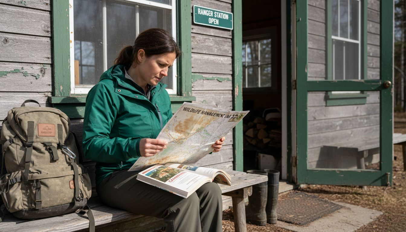
Getting turned around in dense Crown land or crossing an unnoticed property line is a headache no experienced Canadian hunter wants to face. In both Ontario and Alberta, staying within precise hunting boundaries is about more than just tradition, it protects your licence and keeps you on the right side of complex regulations. With features designed for real-world challenges, the HuntScout app offers practical tools to help you avoid common wildlife violations and hunt with confidence.
Table of Contents
- Defining Hunting Boundaries And Common Mistakes
- Wildlife Management Units And Crown Land Zones
- Legal Requirements And Enforcement For Hunters
- Practical Use Of Huntscout For Boundary Navigation
- Obligations, Risks, And Regulatory Compliance
Key Takeaways
| Point | Details |
|---|---|
| Understanding WMUs is Crucial | Wildlife Management Units define specific hunting regulations; knowing them is essential to avoid legal issues. |
| Crown Land Access is Limited | Not all Crown lands are open for hunting; verify specific regulations for each WMU beforehand. |
| Legal Compliance is Essential | Hunters must possess valid licences and tags, and adhere to seasonal restrictions; ignorance of the law is not a defence. |
| Utilize Digital Tools | Use resources like HuntScout for real-time boundary navigation and regulatory updates to avoid accidental violations. |
Defining Hunting Boundaries and Common Mistakes
Navigating hunting boundaries in Ontario and Alberta requires precision and understanding of complex legal landscapes. Hunters must recognize that wildlife management units (WMUs) create specific geographical zones with unique regulations, and crossing these boundaries without proper knowledge can result in significant legal consequences.
Understanding hunting boundaries starts with comprehending common wildlife violations that hunters frequently encounter. These often involve unintentional trespassing, hunting outside designated areas, or misunderstanding property line distinctions between public and private lands. Crown lands present particular challenges, as their boundaries can be intricate and not always clearly marked on standard topographical maps.
Common mistakes include assuming all Crown lands are open for hunting, failing to verify specific WMU regulations, and not checking current land use designations. Hunters must proactively verify their intended hunting location’s status, understanding that Crown land does not automatically mean unrestricted hunting access. Each WMU has specific rules regarding species, hunting methods, and seasonal restrictions that can vary dramatically within short geographical distances.
Pro tip: Always carry detailed, updated maps and use digital mapping tools to confirm exact hunting boundaries before your expedition, preventing potential legal complications.
Here’s a quick comparison of key boundary navigation challenges and best solutions for hunters in Ontario and Alberta:
| Challenge | Ontario | Alberta | Best Solution |
|---|---|---|---|
| Boundary marking | Often unclear on Crown land | Varies by WMU and region | Use detailed digital maps |
| Property line distinctions | Overlapping public/private areas | Mix of Crown, private, and lease | Confirm land status locally |
| WMU regulation differences | Rules change by species & season | Rules differ regionally & annually | Consult recent WMU maps |
| Compliance risk | Licence suspension, penalties | Fines, possible equipment seizure | Proactive research & prep |
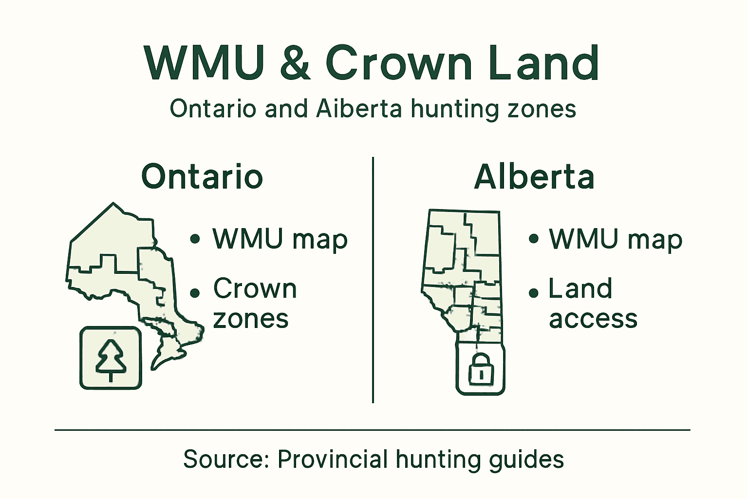
Wildlife Management Units and Crown Land Zones
Wildlife Management Units (WMUs) represent critical geographical frameworks that define hunting regulations across Ontario and Alberta’s diverse landscapes. These precisely delineated zones establish specific rules for species harvesting, hunting methods, and seasonal restrictions that hunters must understand to remain compliant with provincial regulations.
Understanding these management zones requires familiarity with hunting boundary definitions, which establish clear geographic parameters for legal hunting activities. Each Wildlife Management Unit encompasses unique ecological characteristics, population dynamics, and conservation objectives that directly influence hunting permissions. These units are not arbitrary boundaries, but carefully researched geographical regions designed to maintain sustainable wildlife populations and manage human interaction with natural habitats.
In Ontario and Alberta, Crown lands play a significant role in these management strategies. While many hunters assume all Crown lands are open for hunting, the reality is far more nuanced. Different WMUs have specific regulations regarding access, permitted species, and hunting techniques. Some areas might allow general hunting, while others restrict activities to specific seasons or require special permits. Hunters must carefully review the designated regulations for each WMU they intend to hunt, recognizing that boundaries can change based on wildlife population assessments and conservation needs.
A strategic approach involves consulting official provincial wildlife management resources, using digital mapping tools, and verifying current regulations before any hunting expedition. Local wildlife offices and online resources can provide the most up-to-date information on specific WMU restrictions and guidelines.
Pro tip: Always download and review the most recent WMU maps and regulations for your specific hunting region, as boundaries and rules can change annually.
Legal Requirements and Enforcement for Hunters
Hunting in Ontario and Alberta involves navigating a complex web of legal requirements that demand strict adherence and thorough understanding. Provincial wildlife regulations are designed not just to manage hunting activities, but to protect ecological systems, ensure hunter safety, and maintain sustainable wildlife populations across diverse landscapes.
Conservation officers take hunting violations seriously, with enforcement strategies focused on preventing illegal hunting practices. Key legal requirements include possessing valid hunting licences, properly tagged game, adhering to specific seasonal restrictions, and understanding precise boundaries for permitted hunting areas. Hunters must carry all required documentation, including valid provincial hunting permits, wildlife management unit (WMU) specific authorizations, and species-specific tags during their expeditions.
Both Ontario and Alberta employ rigorous enforcement mechanisms to ensure hunters comply with provincial regulations. These include mandatory hunter education courses, random field inspections, and significant penalties for non-compliance. Violations can result in substantial fines, licence suspensions, and potential equipment seizures. Hunters must understand that ignorance of the law is not considered a valid defence, making proactive education and preparation critical to maintaining legal hunting status.
Successful hunters recognise that legal compliance extends beyond mere paperwork. It involves ethical hunting practices, respecting wildlife conservation principles, and maintaining the delicate balance between human recreational activities and ecological preservation. Staying informed about current regulations, attending mandatory training sessions, and consistently verifying documentation are essential strategies for responsible hunting.
Pro tip: Create a pre-hunt checklist that includes verifying all current licences, tags, and specific WMU regulations to prevent accidental legal violations.
Below is a summary of main legal requirements and enforcement strategies for responsible hunting:
| Requirement | Ontario | Alberta | Enforcement Approach |
|---|---|---|---|
| Valid hunting licence | Mandatory for all hunters | Mandatory for all hunters | Licence checks by officers |
| Species tagging | Tags for each harvested | Tags for each harvested | Tag verification onsite |
| WMU-specific permits | Often required | Frequently required | Area-specific inspections |
| Training | Certified courses mandate | Mandatory education course | Training record audits |
| Penalties for violation | Licence loss, fines | Fines, suspensions, seizure | Random inspections, education |
Practical Use of HuntScout for Boundary Navigation
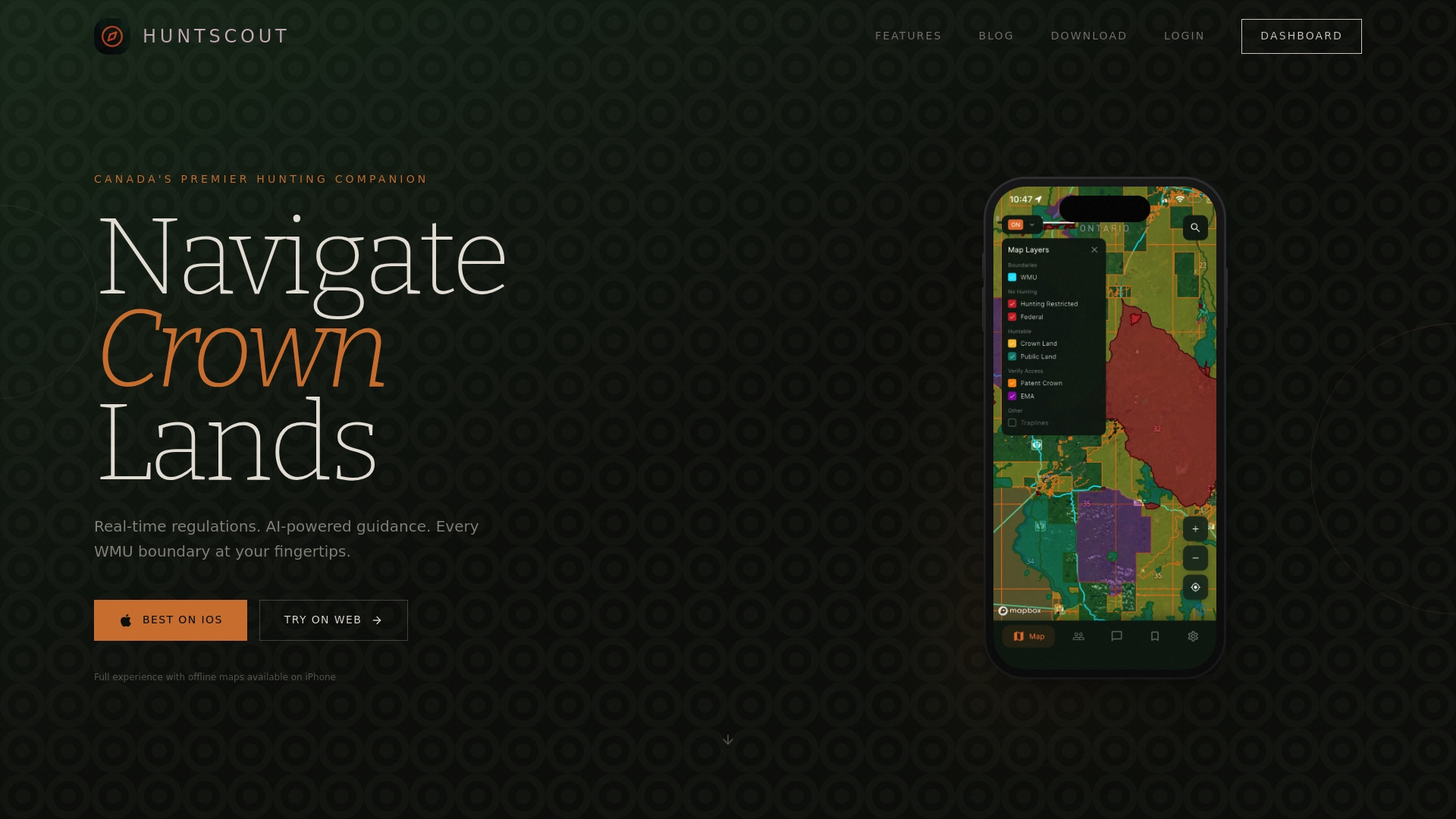
Navigating hunting boundaries in Ontario and Alberta requires precision, local knowledge, and access to real-time geographic information. HuntScout emerges as a critical tool for hunters seeking to understand and respect complex territorial regulations across diverse hunting landscapes.
The platform’s core strength lies in its comprehensive mapping capabilities, offering hunters detailed interactive boundary navigation that transcends traditional paper map limitations. Users can access satellite imagery, precisely marked Wildlife Management Units (WMUs), and real-time updates on hunting zone restrictions. This digital approach allows hunters to instantly verify legal hunting areas, understand specific regional regulations, and make informed decisions about their hunting expeditions.
HuntScout’s boundary navigation features include detailed overlays of Crown land zones, private property boundaries, and seasonal hunting restrictions. The platform’s GPS-enabled interface allows hunters to mark safe hunting locations, track their movements, and receive instant alerts about potential boundary crossings or restricted areas. These technological capabilities dramatically reduce the risk of accidental trespassing or regulatory violations that could result in significant legal consequences.
Beyond mere mapping, the tool integrates AI-powered guidance that interprets complex regulatory information specific to each Wildlife Management Unit. Hunters can access instant clarifications about permitted hunting methods, species-specific rules, and seasonal limitations, transforming complex bureaucratic information into clear, actionable insights that support responsible and legal hunting practices.
Pro tip: Download HuntScout’s offline maps before your hunting expedition to ensure continuous access to boundary information in areas with limited cellular coverage.
Obligations, Risks, and Regulatory Compliance
Hunting in Ontario and Alberta demands a comprehensive understanding of legal obligations that extend far beyond simply obtaining a hunting licence. Hunters are responsible for navigating a complex landscape of regulatory requirements designed to protect wildlife populations, ensure public safety, and maintain ecological balance.
Conservation authorities emphasize the critical nature of hunter obligations and risks, which encompass much more than basic licensing requirements. Legal compliance involves understanding seasonal restrictions, species-specific hunting regulations, proper game tagging procedures, and strict adherence to wildlife management unit boundaries. Violations can result in substantial financial penalties, licence suspensions, and potential criminal charges that can significantly impact a hunter’s future hunting privileges.
The risks associated with non-compliance extend beyond legal consequences. Improper hunting practices can lead to unintentional ecological damage, compromise wildlife conservation efforts, and potentially endanger other hunters and local communities. Hunters must demonstrate a comprehensive understanding of land use regulations, including distinctions between Crown lands, private properties, and restricted hunting zones. This requires ongoing education, careful research, and a commitment to ethical hunting practices that prioritize safety and environmental stewardship.
Regulatory compliance is a dynamic process that requires continuous learning and adaptation. Provincial wildlife management agencies regularly update regulations based on ecological assessments, population studies, and conservation needs. Successful hunters remain proactive, regularly reviewing current guidelines, participating in mandatory education programs, and leveraging technological tools to stay informed about the latest regulatory changes.
Pro tip: Attend annual hunter education refresher courses and maintain a digital folder with current licences, permits, and recent regulatory updates to ensure complete compliance.
Master Hunting Boundaries with Confidence Using HuntScout
Navigating the complex hunting boundaries and regulations across Ontario and Alberta can feel overwhelming and risky. This article highlights the crucial challenges hunters face such as understanding Wildlife Management Units, correctly identifying Crown land zones, and staying compliant with shifting provincial rules. Uncertainty around boundaries and legal requirements often leads to unintentional violations with serious consequences. With HuntScout, you gain a powerful ally that transforms these complexities into clarity and control.
HuntScout.app offers real-time boundary navigation, detailed Crown land maps, and AI-powered guidance that instantly answers your hunting regulation questions specific to Canadian provinces. Stay ahead with up-to-date WMU information and track seasons confidently while offline. Don’t risk costly penalties or licence suspensions because of unclear boundaries. Take control of your hunting experience today by visiting HuntScout and equip yourself with the ultimate Canadian hunting companion. Every responsible hunter deserves the peace of mind that comes from being fully informed and legally prepared.
Frequently Asked Questions
What are Wildlife Management Units (WMUs) and why are they important for hunters?
Wildlife Management Units (WMUs) are specific geographical zones that define hunting regulations, including species harvesting, hunting methods, and seasonal restrictions. Understanding WMUs is crucial to remain compliant with provincial hunting laws.
What common mistakes do hunters make regarding hunting boundaries?
Common mistakes include assuming all Crown lands are open for hunting, failing to verify WMU regulations, and misunderstanding property line distinctions. Hunters should always check the status of their intended hunting location before heading out.
How can I stay compliant with hunting regulations in my area?
To stay compliant, hunters should familiarize themselves with local WMU regulations, possess valid hunting licenses and tags, and continuously verify the boundaries and rules for their hunting zones. Proactive education and preparation are key.
What is the role of technology in navigating hunting boundaries?
Technology, such as mapping tools like HuntScout, provides real-time navigation and boundary verification. These tools help hunters access updated WMU data and avoid unintentional legal violations by delineating specific hunting zones and restrictions.

