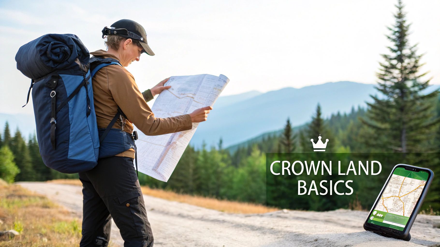
To find the best, most accessible hunting spots, you need a solid crown land in BC map. These maps are your key to telling the difference between public General Use Crown Land—which is most of the province—and private property or other no-go zones. Getting comfortable with these maps is the absolute first step in planning a legal and successful hunt.
Getting to Know BC Crown Land as a Hunter
Imagine British Columbia's massive landscape as a patchwork quilt. Some patches are like a public library—open for everyone to use for things like hunting, as long as you play by the rules. That's your Crown land. Other patches are like a private, members-only club where you need a special invitation to get in. That's private land.
Knowing which is which isn't just a good idea; it's the bedrock of ethical and legal hunting.
The sheer amount of public land here is staggering. British Columbia's Crown land covers over 366 million acres, which works out to about 9.5% of all Crown land in Canada. This vast territory opens up an incredible world of opportunity for hunters, spanning every kind of ecosystem imaginable. Statistics Canada provides more detail on these extensive public lands.
What is General Use Crown Land?
As a hunter, your main focus will be on General Use Crown Land. This is land owned by the public and managed by the province, and for the most part, it’s open for recreational activities like hunting. It’s the default status for the vast majority of the backcountry you’ll see on a map.
But it's not quite that simple. Not all public land is created equal, and it’s critical to know the difference between General Use areas and other land types that come with heavy restrictions:
- Provincial Parks and Protected Areas: In these zones, hunting is usually either completely prohibited or severely restricted.
- Federal Lands: This category includes National Parks, where hunting is a definite no.
- Leased or Licensed Crown Land: You might find areas leased for forestry, cattle grazing, or mining. These activities can impact your access.
- Private Property: This is off-limits unless you have explicit permission from the landowner. No exceptions.
How Wildlife Management Units Fit In
On top of these land types, you have another important layer: Wildlife Management Units (WMUs).
Think of WMUs as specific rulebooks for different parts of the province. Each unit has its own set of regulations covering everything from hunting seasons and bag limits to species-specific rules. Any good crown land in BC map will clearly show these WMU boundaries, so you can be confident you know which regulations apply to your precise location.
For a more thorough breakdown, you can read our complete guide explaining what is crown land in Canada.
Comparing Official Data with Modern Hunting Apps
When you're looking for a reliable crown land in BC map, you really have two roads you can go down. The first leads to official government sources—the absolute bedrock of all land data in the province. The second path takes you to modern hunting apps, which are built to translate that official data for practical, in-the-field use.
Think of it this way: the government portals are like the master architectural blueprints for a house. They're technically precise, incredibly detailed, and the ultimate source of truth. But if you’re the one swinging the hammer, those blueprints can be a real headache to read. A good hunting app is like the general contractor who turns those complex plans into a clear, step-by-step guide you can actually use.
The Authoritative Government Sources
The Province of British Columbia is the keeper of that master blueprint. For well over a century, it has meticulously recorded land ownership and use. In fact, BC has kept comprehensive crown land records since the 1850s. This information was digitized back in the 1980s and eventually brought online in the 1990s.
Today, the government's Crown Land Registry, known as Tantalis, is the central database. The public can dig into it using the Government Access Tool for Online Retrieval (GATOR). You can learn more about how to access the Crown Land Registry and its history right on the government's website.
While tools like GATOR and ParcelMap BC are powerful and dead-on accurate, they were built for surveyors, land managers, and researchers—not for a hunter trying to figure things out on a remote logging road. Their interfaces can feel clunky, load slowly, and they certainly weren't designed for offline use when you've lost cell signal.
Key Takeaway: Official sources give you the raw, authoritative data. They answer the "what" of land ownership perfectly but often fall short on the user-friendly "how" needed for efficient hunt planning and navigation.
The Modern App Advantage
This is exactly where dedicated hunting apps like HuntScout come into play. They take that dense, raw data from official sources and repackage it into an intuitive, powerful tool designed from the ground up for a hunter's needs. The core information is identical, but the way it's delivered is a world apart.
A quality app acts as an expert translator. It overlays the authoritative Crown land data onto high-resolution satellite maps, adds in your WMU boundaries, and even integrates hunting season dates. All of a sudden, you're not just staring at abstract property lines on a plain map; you're seeing a clear picture of where you can legally hunt, what's in season, and what the terrain actually looks like on the ground.
This approach saves a massive amount of time and cuts out the guesswork. Instead of cross-referencing multiple government websites and clunky PDF maps, you have a single, streamlined resource on your phone that works even when you're miles from the nearest cell tower. If you're weighing your options, you can check out a breakdown of the best hunting apps available in Canada.
Comparing Crown Land Map Resources
To put it all in perspective, here's a side-by-side look at how official portals stack up against a dedicated hunting app for the average hunter.
| Feature | Government Portals (e.g., GATOR) | Hunting Apps (e.g., HuntScout) |
|---|---|---|
| Data Accuracy | Authoritative and the ultimate source of truth. | Highly accurate; directly sources and processes official government data. |
| Ease of Use | Often complex, with steep learning curves and clunky interfaces. | Intuitive, user-friendly, and designed for quick in-field checks. |
| Offline Access | Not designed for offline use; requires an internet connection. | Core function. Maps and layers can be saved for use anywhere. |
| Map Layers | Basic property and topographic layers. Separate sites for other data. | Multiple integrated layers: satellite, topo, private/public land, WMUs, etc. |
| Hunting-Specific Tools | None. Designed for general land administration. | Built-in tools: waypoints, tracking, season dates, wind/weather info. |
| Speed & Performance | Can be slow to load, especially on mobile devices. | Optimized for fast performance on mobile, even with complex layers. |
Ultimately, while government portals are the indispensable source of the data itself, a modern hunting app is the tool that makes that data truly useful for planning and executing a successful hunt.
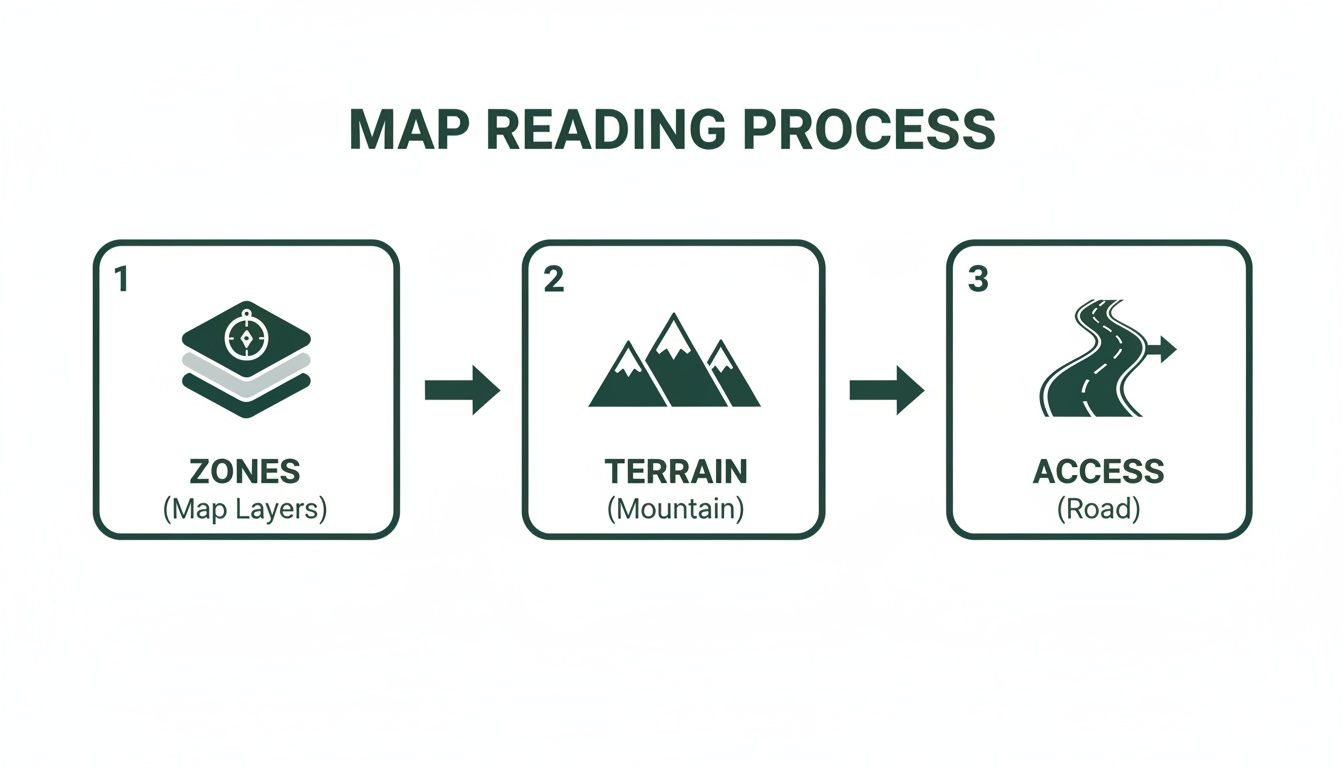
How to Read and Interpret Your Hunting Map
Opening up a good digital hunting map for the first time can feel a little overwhelming. It's not just a picture of the ground; it's a rich, layered story about the landscape, told through colours, lines, and symbols. Learning to read this story is what separates wandering from actual hunting.
At its core, the map uses colour to instantly tell you about land status—this is the first thing you need to get comfortable with. You'll quickly learn to spot the specific shade that means General Use Crown Land, which is where you'll be spending most of your time. Just as crucial are the colours that shout "stay out," marking private property, parks, and other no-go zones.
Decoding the Essential Map Layers
Beyond just land status, a powerful crown land in BC map is built on layers. Think of them like transparent sheets you can toggle on and off, each one adding a new piece of the puzzle to your view.
For any hunter in British Columbia, these are the must-know layers:
- Wildlife Management Units (WMUs): This layer shows you the precise boundaries for every WMU. It's how you confirm, without a doubt, which unit you're standing in so you can be sure you're following the right season dates and regulations.
- Topographical Lines: You'll see these as a web of squiggly "topo" lines. They reveal the steepness of the terrain. When lines are packed tightly together, you're looking at a steep climb. When they're spread far apart, the ground is gentle or flat.
- Water Bodies and Rivers: This layer is your guide to life-sustaining water. It highlights everything from tiny creeks to major rivers and hidden swamps, pointing you toward spots where animals will inevitably show up.
- Roads and Trails: This shows your access network, from paved highways down to the faint forestry service roads (FSRs) and old quad tracks that get you deep into the backcountry.
A map isn't just about avoiding a trespassing ticket; it's about building a strategy. When you combine topographical data with satellite imagery, you can spot natural funnels, hidden clearings, and benches where game will almost certainly travel or bed down.
Reading the Terrain Before You Go
Once you're comfortable switching between these layers, you start seeing the landscape in a whole new way. You can trace a creek up a mountainside on the topo map and find a hidden basin that looks promising. You might spot a steep ridge that would make a perfect glassing point or identify a saddle between two peaks that just screams "animal highway."
This is how you move from simply looking at a map to truly interpreting it. Instead of just searching for big blobs of Crown land, you're actively picking apart the terrain to find high-percentage spots. To get familiar with all the units you'll encounter, you can explore our detailed guide to British Columbia WMU boundaries. This is how you plan your hunt with confidence, knowing exactly what to expect before your boots ever hit the trail.
A Practical Method for E-Scouting BC Crown Land
This is where the rubber meets the road—or, in our case, where the cursor meets the map. A solid e-scouting workflow is the difference between aimlessly panning across a digital map for hours and surgically pinpointing your next hunting spot from your couch. The idea is simple: start big and systematically work your way down to a specific, huntable location.
Modern mapping tools make this whole process incredibly efficient. Think of it like building a custom map, where you can stack different transparent layers of information on top of each other to see the complete picture.
Start with the 30,000-Foot View
First things first, zoom out. You want to get a feel for the major blocks of accessible Crown land in the region you're interested in. On your crown land in BC map, look for large, uninterrupted swaths of green that are a good distance from towns and cities but still show some signs of road access.
At this stage, your only goal is to find a few big, promising areas that deserve a closer look. You're not trying to find the exact ridge you'll be glassing from. You're just filtering out the noise and narrowing the entire province down to a handful of high-potential zones. This macro approach saves a ton of time by getting the obviously unsuitable spots off the table right away.
Zoom In and Hunt for Habitat
Once you’ve tagged a few broad areas, it’s time to drill down. Switch your map over to a high-resolution satellite view. This is where you stop looking at green blobs and start looking for the specific features that attract and hold the game you're after.
What should you be looking for? Things that animals need and use:
- Edges and Openings: Animals love edges. The transition between an old clear-cut and standing timber is a fantastic place for deer and moose to feed while staying close to cover. Natural meadows work the same way.
- Funnels and Saddles: The terrain itself can do the work for you. Animals are lazy, just like us. They’ll take the path of least resistance, which is often a low saddle on a ridge or a narrow pinch point between two lakes. These are natural funnels.
- Water Sources: Every animal needs water. Creeks, hidden ponds, and beaver dams are magnets for wildlife, especially when things get dry later in the season.
This process is all about reading the landscape. You're trying to understand how an animal would move through it by identifying huntable zones, analyzing the terrain, and figuring out how you can get in there.
By layering these pieces of information, you start to build a really clear picture of a spot's potential before you even burn a drop of gas.
Trace Your Access and Check the Boundaries
Okay, you've found a spot that looks amazing on satellite. Now, how do you get there? This is where you trace your access. Use the road and trail layers to find Forestry Service Roads (FSRs), old logging spurs, or even quad trails that snake into the area. I always flip back to the satellite view to sanity-check the route for potential washouts, slides, or deactivated bridges that the map might not show.
This is also the most important step for staying legal. Zoom in as close as you can on the property boundaries around your chosen location. You need to be absolutely certain that your entire route and the spot you plan to hunt are on General Use Crown Land. Meticulously trace the lines to avoid accidentally stepping onto private property, a First Nation reserve, or another restricted area.
Hunter's Tip: Just because a road is on the map doesn't mean it's open. It could be gated, washed out, or have fresh "No Trespassing" signs. I learned this the hard way. Always have a Plan B and even a Plan C for access.
Finally, confirm the WMU. A good mapping app like HuntScout makes this dead simple—it's usually just a layer you can turn on. A quick tap will show you exactly which WMU you're in, allowing you to instantly cross-reference your spot with the specific season dates and regulations for your target species. It ensures your whole plan is above board.
Turning Your Map into a Field-Ready Plan
Finding a great-looking spot on a map is the easy part. The real test comes when you have boots on the ground, trying to navigate that terrain safely and efficiently. This is where a modern crown land in BC map goes from being a research tool to an indispensable piece of field gear, especially when you’re deep in the backcountry.
For any serious hunter, the most critical feature is offline maps. Let’s be honest, cell service is a rare luxury once you’re a few kilometres down a logging road. A solid mapping app lets you download entire areas—satellite imagery, property lines, topo contours, and all—right to your phone before you lose signal.
With those maps saved, your phone’s GPS still works perfectly, showing your exact location on that detailed map even when you have zero bars. It’s the difference between moving with confidence and being hopelessly, dangerously lost.
Tools for On-the-Ground Strategy
Once your offline maps are loaded, you can start using other tools that help you execute the hunt and adapt to what you find. Think of these features as building a personalized, living journal of your hunting spots.
- Custom Waypoints: These are your digital breadcrumbs. Drop a pin to mark your truck, a potential campsite, a fresh rub, or a well-used game trail you just stumbled upon. Naming them and using different icons helps you instantly understand what you’re looking at.
- Route Tracking: This function records your exact path as you hike. It’s a lifesaver for finding your way back to camp in the dark, but it’s also great for reviewing your hunt later. You can see how much ground you covered, what kind of terrain it was, and figure out better routes for next time.
Bringing Regulations and History into the Picture
The best digital maps do more than just show you where you are; they tell you what you can do there. Integrated hunting season information is a game-changer. It shows you exactly what’s open or closed for your specific location within a WMU, saving you from constantly flipping through the regulation synopsis.
Understanding the map also means understanding how it got to be the way it is. The patchwork of Crown and private land we see today didn't just appear overnight. British Columbia had unique land acquisition policies, like Pre-emption, a practice from 1859 to 1970 that allowed settlers to claim Crown land for farming. This history helps explain why ownership patterns and access can seem so strange and varied across the province. You can dig deeper into BC's historical land records and their impact on surreylibraries.ca.
Crucial Takeaway: A successful hunt is about more than just finding a good spot. It’s about having the right tools to navigate safely, make smart decisions on the fly, and stay on the right side of the law. Offline maps, waypoints, and built-in regulations aren't just nice-to-haves; they're essential for any modern hunter.
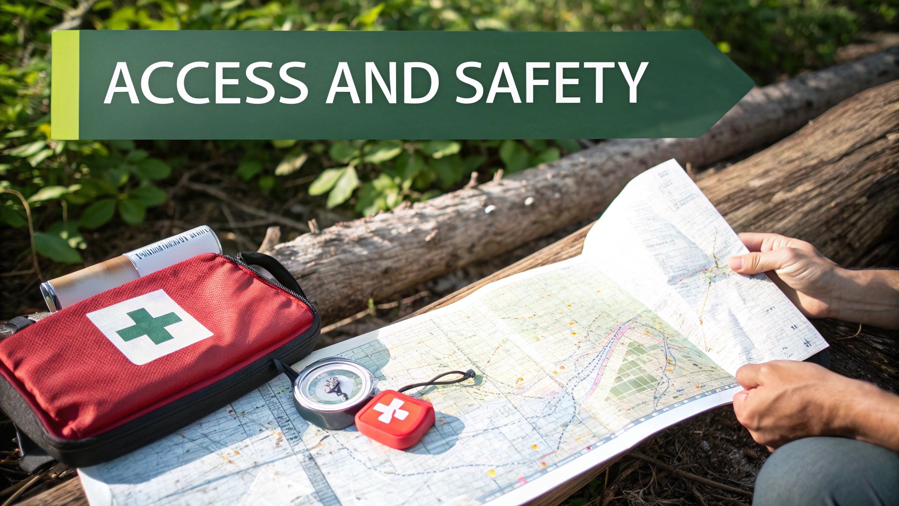
Navigating Legal Access and Backcountry Safety
Hunting on Crown land is a privilege, not a guarantee, and it comes with some serious responsibilities. While your crown land in BC map is your best friend for planning, what you see on the ground always wins. A posted "No Trespassing" sign is the final word, no matter what your map or GPS tells you.
You also have to remember that much of BC's Crown land is a working landscape. You’re likely to run into active logging operations, cattle grazing on range tenures, or temporary closures for things like wildfire management. Always be aware of your surroundings and give industrial sites a wide berth—your hunt isn't worth interfering with someone's livelihood.
Rules of the Road and Respect for the Land
Getting to these spots usually means travelling on forestry service roads (FSRs). These aren't your typical public highways. They're industrial roads, and a loaded logging truck always has the right-of-way. Drive slowly, keep your headlights on, and be ready to pull over for commercial traffic. They aren't expecting you, but you should always be expecting them.
Being a responsible steward of the land is non-negotiable. It means packing out everything you pack in, minimizing your impact, and leaving your campsite cleaner than you found it. This isn't just about following rules; it's about preserving this incredible resource for everyone.
This commitment to stewardship directly affects whether we'll all have access in the future. It’s on us, as a community, to make sure these lands stay healthy and open for the next generation of hunters.
Backcountry Preparedness Is Not Optional
Once you're deep in the bush, you are on your own. The weather can turn on a dime, the terrain can be unforgiving, and help is a long way off. Heading out without reliable offline maps, a compass, and knowing how to use both is just asking for trouble.
Your safety kit is your lifeline. At a minimum, it should include:
- A solid first-aid kit designed to handle serious injuries.
- Multiple ways to start a fire.
- Extra food, water, and insulating layers in case you're out longer than planned.
- A satellite communication device like an inReach or SPOT for true emergencies.
In the end, your safety is your responsibility. Meticulous planning and a healthy dose of respect for the wild are just as critical as knowing how to read your map.
Got Questions About BC Crown Land Maps? We've Got Answers.
When you start digging into the rules and regulations for public land, it's natural for a few questions to pop up. Honestly, it can be a bit confusing at first. Let's clear the air and tackle some of the most common things hunters ask when looking at a crown land in BC map.
Is All Crown Land Actually Open for Hunting?
This is a big one, and the short answer is no. Not all Crown land in BC is fair game for hunting.
While the vast majority is designated as General Use Crown Land—which is typically where we can hunt—there are plenty of other classifications to watch out for. Think of provincial parks, ecological reserves, protected areas, and even specific land leases. These areas often come with their own set of rules that either restrict or completely prohibit hunting.
The only way to know for sure is to use a map that clearly lays out these different land statuses. It's the difference between a great hunt and a serious mistake.
Here's a critical piece of advice: Your digital map is your best friend, but signs on the ground are the final authority. If you see a "No Trespassing" sign, it overrules whatever your map says. Land ownership data can sometimes lag, and respecting posted boundaries isn't just good manners—it's a non-negotiable part of being an ethical hunter.
So, Can I Just Set Up Camp Anywhere on Crown Land?
For Canadian residents, the good news is you can generally camp on Crown land for up to 14 consecutive days in the same spot without a permit. It's an incredible privilege we have here.
But with that freedom comes responsibility. You're expected to leave the land exactly as you found it (leave-no-trace is the golden rule). Also, be aware that local restrictions or fire bans can be put in place, especially during the dry season. Always check the latest provincial and regional alerts before you even think about lighting a campfire.
How Accurate Are the Boundaries on These Digital Maps Anyway?
This is a fair question. The best mapping tools, like the ones we've discussed, pull their data straight from official government sources like the Crown Land Registry. So, the data itself is highly accurate.
The key thing to remember, though, is that this data is a snapshot in time. Land can be sold, leases can change, and new restrictions can be added. That’s why it's so important to make sure your maps are always updated to the latest version. An old map is just a pretty picture; an updated one is a reliable tool.
For a mapping experience that's built from the ground up for Canadian hunters, check out HuntScout. It offers clear, reliable layers for Crown land, private property, and WMUs, taking the guesswork out of your planning. Map out your next adventure with confidence at https://huntscout.app.

