If you’re new to hunting in Ontario, the term “Wildlife Management Unit” or “WMU” is something you’ll hear constantly. But what exactly is it? Think of a WMU as a specific, mapped-out zone created by the province to manage wildlife and regulate hunting. It’s the absolute foundation for planning any legal hunt here.
Each WMU has its own unique set of rules based on the local environment and the health of its wildlife populations. It's a bit like how a city is divided into different wards for elections; each area has its own specific needs and is managed accordingly.
What Are Ontario's Wildlife Management Units
Trying to apply one set of hunting regulations to all of Ontario would be a recipe for disaster. The wildlife and landscape in the southern farmlands are completely different from what you'd find in the vast northern boreal forests. An area with a thriving deer population needs a different management plan than one where moose numbers might be struggling. This is exactly why the province is divided into WMUs.
The Ministry of Natural Resources and Forestry (MNRF) is the organization behind this system, carving the province into dozens of distinct zones. Each WMU functions like its own self-contained management area, which allows for regulations that are finely tuned to the ecological reality on the ground.
Why The WMU System Exists
At its heart, the WMU system is all about sustainable conservation. It gives wildlife biologists and conservation officers the tools they need to monitor animal populations at a local level, gather precise harvest data from hunters, and make smart, evidence-based decisions. This approach ensures that hunting remains a sustainable activity that doesn't harm animal populations, protecting our natural heritage for generations to come.
To give you a better idea of how this all works, here's a quick breakdown of what the WMU system accomplishes for your hunt.
Core Components of the WMU System
This table breaks down the fundamental concepts of the WMU system, giving you a quick reference for how it directly affects your hunt.
| Concept | What It Means for Hunters |
|---|---|
| Localized Management | The rules for your hunt—like season dates and bag limits—are tailored to the specific area you're in, not a generic provincial policy. |
| Data Collection | When you report your harvest, that information helps biologists understand population trends in that specific WMU. |
| Sustainable Harvest | Your tag allocation and the season dates are adjusted each year based on data to keep animal populations healthy and balanced. |
Ultimately, this structure strikes a crucial balance between providing recreational hunting opportunities and upholding our responsibility to conservation. It elevates hunting from a simple pastime to an active role in modern wildlife management.
The Legal Side and Scale of It All
These aren’t just suggestions or informal zones; wildlife management units in Ontario are legally defined areas. The boundaries for all 88 WMUs are meticulously laid out in Ontario Regulation 663/98, which is part of the Fish and Wildlife Conservation Act. This legal framework is the backbone of all regulated hunting in the province.
It's a system that works. For instance, the total deer harvest across all WMUs in 2021 was over 60,000 animals, a number that shows how well the system can manage healthy populations for ethical hunting. You can dive deeper into this kind of data on the Government of Canada's open data portal.
Knowing your WMU isn't just a good idea—it's the most critical first step for any hunter in Ontario. It tells you exactly where you can hunt, what you can harvest, and when you can be out there. This is especially true when you're exploring new ground, like the incredible hunting opportunities on public lands. If you're looking for new spots, you might find our guide on how to find and hunt Ontario Crown Land helpful.
How WMUs Dictate Your Entire Hunt
Knowing what a Wildlife Management Unit is is the first step. But truly understanding how these invisible lines on a map control every single aspect of your hunt? That's what separates a successful hunter from a frustrated one.
Think of each WMU as its own little world with its own set of rules. The moment you step across a boundary, you're playing a completely different game—even if the trees and fields look exactly the same. This isn't a minor detail; it’s the absolute foundation of hunting in Ontario. A deer tag for the farm country of WMU 80 is completely useless a few kilometres down the road in the thick bush of WMU 79. Mastering this system isn't optional.
Seasons and Bag Limits: A Tale of Two WMUs
The most direct way WMUs affect you is through hunting seasons and bag limits. The rules can change dramatically from one unit to the next, all based on the health and numbers of local wildlife populations.
Let's use a real-world example. Say you're planning a deer hunt.
Down south in an agricultural unit like WMU 85, you'll likely find a long archery season, a controlled shotgun hunt, and a muzzleloader season. Thanks to the stable deer population fed by abundant farmland, bag limits might be more generous, and you might even have a shot at an antlerless tag.
Now, let's head north to a boreal forest unit like WMU 22. The ecosystem here is totally different. The deer population is likely smaller and more sensitive to hunting pressure. Because of this, the season might be much shorter—maybe just a brief rifle hunt—and antlerless tags could be extremely rare or not offered at all to protect the breeding stock.
This contrast makes one thing crystal clear: just knowing "deer season is open in Ontario" is dangerously incomplete information. Your hunt is only legal if the season is open in the specific WMU where you're standing.
A hunting licence or tag is only valid for the specific species, season, and Wildlife Management Unit for which it was issued. Using a tag outside its designated WMU is a serious offence, equivalent to hunting without a valid tag at all.
This strict rule ensures that hunting pressure is applied exactly where local wildlife can sustain it, and not where it can't.
Why Are the Rules So Different?
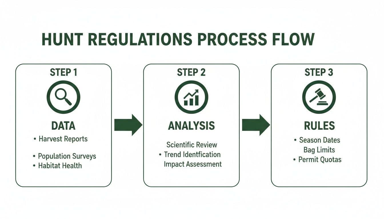
The differences between WMUs aren't just pulled out of a hat. They’re the result of careful, on-the-ground data collection and analysis by wildlife biologists. It's this data-driven approach that keeps Ontario’s wildlife management effective.
Biologists look at several key factors to set the regulations for each unit:
- Aerial Surveys: They literally fly over units to count animals like moose, which gives them solid population estimates and helps them see the ratio of males to females and adults to calves.
- Harvest Reports: When you and I report our harvests, that mandatory step provides crucial data on how many animals of each species and sex are being taken in every single WMU.
- Local Ecological Factors: Things like how harsh the winter was, outbreaks of disease like Chronic Wasting Disease, and the quality of the habitat are all part of the equation.
This constant stream of information lets the MNRF make very precise adjustments. For example, if harvest data shows a drop in the number of bull moose in a particular unit, they'll reduce the number of tags available there next season to help the population bounce back. It's this surgical approach that makes modern conservation work.
For a great picture of this in action, look at WMU 13, deep in northern Ontario's boreal forest. During the 2022 season, data showed a harvest of 450 bull moose, balanced against 120 cows and 80 calves. This careful management, guided by regular aerial surveys and tag allocations, kept the local sex ratio healthy and above the provincial guideline. This kind of detailed focus contributed to a province-wide strategy that kept total moose harvests under 4,500 in 2023, a targeted effort to support populations across the north. You can dive into the complete harvest data and see exactly how these numbers shape Ontario's hunting regulations.
At the end of the day, your licence and tags aren't just a permission slip. They’re a crucial tool for wildlife management, tied directly to the health of the specific piece of ground you plan to hunt.
Find Your Exact WMU in Seconds
Knowing why Wildlife Management Units exist is one thing, but knowing how to find your exact location on the map is what keeps a hunt legal and stress-free. This is especially true when you're working the edge of a boundary line. Guessing is not an option.
Thankfully, you have several ways to pinpoint your WMU, from old-school government resources to modern apps made for the field. Let's walk through how to find your unit with confidence, looking at the pros and cons of each method.
Traditional Government Resources
For decades, hunters have relied on two main sources from the Ministry of Natural Resources and Forestry (MNRF) to figure out which Wildlife Management Unit they're in.
First is the annual Ontario Hunting Regulations Summary. You can find it online as a PDF or grab a printed copy. It's the official rulebook, but the maps inside are pretty basic. They give you a general idea of WMU locations but lack the detail you need for precise navigation, making it tough to know for sure if you're on the right side of a boundary.
The second option is the government's online "Make a Map" tool. This is a big improvement, giving you an interactive map where you can switch on the WMU boundary layer. It's a great tool for planning your hunt from a desktop computer at home, letting you zoom in on satellite or topographic views. The biggest downside? It's not built for your phone and is pretty much useless in the bush where cell service is spotty or non-existent.
The regulations you find in these resources aren't just pulled out of thin air. They're the result of a careful process of data collection and scientific review.
This process ensures that the rules for each WMU are based on solid wildlife science, not just random decisions.
Modern Field-Ready Solutions
For hunters who need instant, accurate information on the ground, specialized hunting apps have become the go-to tool. They solve the biggest headaches of the traditional methods by blending official data with the tech we all carry in our pockets.
Apps like HuntScout are designed specifically for Canadian hunters. They take the official WMU boundary layers and overlay them directly onto high-resolution satellite maps you can use right on your phone.
The real game-changer with a modern app is its use of your phone's GPS. It pinpoints your live location—that little blue dot—right on the map, so there’s zero doubt about which WMU you’re standing in.
This feature is invaluable when you're hunting a property line or a creek that marks a boundary. A quick glance at your screen gives you immediate confirmation, preventing a simple mistake that could turn into a serious infraction.
Comparing WMU Identification Tools
Choosing the right tool depends on your situation. Are you planning at home or trying to confirm your location in the field? This table breaks down the pros and cons to help you decide.
| Method | Pros | Cons | Best For |
|---|---|---|---|
| Hunting Regulations Summary | Official source, available offline (print), free. | Maps lack detail, not interactive, hard to pinpoint exact location. | Reviewing seasons and rules; getting a general overview of WMU areas. |
| MNRF "Make a Map" | Interactive, multiple map layers, official boundary data. | Requires internet, not mobile-friendly, clunky to use in the field. | At-home planning and detailed boundary research on a computer. |
| Hunting Apps (e.g., HuntScout) | Live GPS location, offline map access, easy to use on mobile. | Often requires a subscription for full features. | In-the-field navigation, confirming your exact position, and on-the-go planning. |
While government resources are essential for understanding the rules, nothing beats a dedicated app for on-the-ground confidence.
Instant Identification with the Right Tool
Using an app just makes life simpler. Instead of squinting at a paper map and trying to match it to the treeline in front of you, you just open your phone and know.
With a proper Ontario WMU map tool, you can see exactly where you are in relation to the WMU line, giving you a level of certainty a paper map could never provide. This takes the guesswork out of staying compliant.
Plus, features like offline maps mean you can download your hunting area before you leave home. That way, you have full navigation and boundary information even when you’re deep in the backcountry without a single bar of service. It’s about having the right information, right when you need it most.
Strategic Hunt Planning with WMU Data

Knowing your Wildlife Management Unit is more than just a box to tick for legal reasons—it's the foundation of a smart, successful hunt. Once you get a feel for the specific landscape and rules of your chosen unit, you stop just showing up and start hunting with real purpose. This whole strategic mindset kicks in long before you ever pull on your boots, starting right from your couch with digital scouting.
Think of your WMU as a digital search filter. It lets you narrow down promising hunting spots from home, a process we call "e-scouting." It's all about using technology to slice up a huge area into manageable chunks, saving you a ton of time and boot leather when you finally get out there.
E-Scouting Crown Land within Your WMU
Ontario has a ton of Crown Land, which is fantastic for hunters. But staring at a map of a massive WMU can feel like trying to find a needle in a haystack. This is where modern mapping tools really shine. Layering your WMU boundary over a good satellite map is the first step to breaking down the terrain.
From there, you start looking for the kinds of features that wildlife can't resist.
- Reading the Topo Lines: Use the contour lines to find saddles, benches, and pinch points that act like natural funnels for animal movement. A high ridge can be the perfect spot to sit and glass for hours, while a swampy bottom offers the thick cover animals need to feel safe.
- Finding Your Way In (and Out): Pinpoint access roads, ATV trails, and waterways. But pay special attention to the spots that look hard to get to. A long hike or a paddle in can often be the ticket to finding animals that haven't been pressured.
- Hunting the Edges: Look for those transition zones where two habitats meet—like where a dense forest gives way to a marsh, or a clear-cut borders a stand of mature timber. These "edges" are highways for wildlife and hotspots for feeding.
Doing this homework on your computer gives you a shortlist of high-potential spots to check out in person. You’ve just turned a random wander through the bush into a targeted mission.
Planning your hunt around WMU-specific data isn't just about following rules; it's about using those rules to your advantage. Knowing about a local firearm restriction or a disease surveillance zone before you go prevents nasty surprises and lets you focus on the hunt itself.
This level of prep work means you're hunting both legally and efficiently. It saves you the headache of finding a perfect-looking spot, only to realize you can't use your rifle there.
Digging Deeper than Just Season Dates
A truly solid plan goes way beyond just knowing the opening and closing days. Every single one of the wildlife management units in Ontario can have its own little quirks and regulations that dictate how, when, and where you hunt. Overlooking these details is a classic mistake that can wreck a hunt before it even starts.
For example, the MNRF might put special conditions on a unit for conservation reasons. One WMU might restrict you to shotguns and muzzleloaders for deer season because it’s close to a populated area. Another might be a mandatory Chronic Wasting Disease (CWD) surveillance zone, meaning you have to submit a sample from any animal you harvest. For the most current info, always double-check the official Ontario hunting seasons and regulations.
Navigating Safely Near WMU Boundaries
Hunting close to a WMU boundary demands your full attention. A few steps in the wrong direction could put you in a different unit with a whole different set of rules, leading to a serious violation. This is where your phone and a good GPS app become your best friends.
Using a hunting app with live GPS tracking shows you exactly where you are on the map in real-time. It takes all the guesswork out of knowing which side of a line you're on. Before you even leave home, download offline maps of your hunting area. That way, your navigation tools will work flawlessly even when you’re deep in the bush with zero cell service.
A great trick is to mark the boundary line as a waypoint or route in your app. You can even set alerts to buzz your phone when you get close. This simple step keeps you aware of your surroundings and lets you hunt with confidence, knowing you’re not about to accidentally cross into a zone where your tag is no good or the season is closed. At the end of the day, a smart plan built on accurate WMU data is the key to every safe, legal, and memorable hunt.
Avoiding Common WMU Hunting Mistakes
Even seasoned hunters can get tripped up by the rules surrounding wildlife management units in Ontario. It doesn't take much—a simple assumption or a small oversight can lead to a serious violation, quickly turning a perfect day outdoors into a frustrating and expensive mess. Knowing the common pitfalls is the best way to steer clear of them.
And make no mistake, the consequences for getting it wrong are more than just a slap on thewrist. We're talking steep fines, confiscated gear, and even the loss of your hunting licence. The good news? Most of these mistakes are completely avoidable with a bit of prep and the right tools. Think of this as your guide to staying legal and hunting with confidence.
Assuming Last Year's Rules Still Apply
Relying on old knowledge is probably the most common trap hunters fall into. Hunting regulations aren't static; they change from year to year based on wildlife population studies and conservation goals. A season that ran late into October last year might now shut down a week earlier.
For instance, the Ministry might decide to open a new fall turkey season in a few southern WMUs, like they did in units 60, 63, and 70, or they might shorten a deer hunt up north to help a herd recover. Just assuming the rules haven't changed is a gamble you don't want to take.
The Fix: Before every season, make it a non-negotiable habit to check the current year's official Ontario Hunting Regulations Summary. That document is the final word. Even better, a modern hunting app will automatically update with the latest season dates and rules for every single WMU, so the info in your pocket is always correct.
Misidentifying a Boundary Line
It's surprisingly easy to get turned around out there, especially when you're locked onto a track. That creek, farmer's fence, or old logging road might look like an obvious border, but the official WMU line on the map could be something else entirely. Unknowingly stepping over that invisible line means you could be hunting illegally.
Picture this: you're on a hot track, following a deer along a ridge in WMU 76A. It crosses a small stream and disappears into the woods. If you follow without checking your map, you might not realize that stream is the official boundary, and you've just wandered into WMU 77B where your tag is no good.
A conversation with a conservation officer that starts with "I thought I was still in..." rarely ends well. Ignorance of your location isn't a defence. The responsibility to know exactly which WMU you are standing in falls squarely on you, the hunter.
This is where just relying on memory or that old paper map stuffed in your pack can really let you down. Precision is everything.
Using the Wrong Tag for Your Location
This mistake usually goes hand-in-hand with misidentifying a boundary. Many tags are issued for a specific WMU, especially for things like controlled hunts or antlerless deer. A tag for WMU 80 is worthless anywhere but WMU 80—period.
It’s an easy slip-up to make, but the consequences are serious. Taking an animal with a tag that isn't valid for your location is legally the same as poaching. Your licence, your tag, and your physical spot on the map all have to line up perfectly.
The Fix for Boundary and Tag Issues: Thankfully, technology gives us a simple, powerful solution. A GPS-enabled hunting app on your phone, like HuntScout, takes all the guesswork out of the equation. It overlays the official WMU boundaries right onto a satellite map and shows your exact location as a little blue dot.
A quick glance at your screen tells you precisely where you are in relation to a boundary line, confirming you’re in the right unit for the tag in your pocket. You can even download maps for offline use before you head out, so it works perfectly even when you're miles from the nearest cell tower. It's the surest way to hunt with peace of mind and stay on the right side of the law.
Your Top Questions About Ontario WMUs Answered
Once you get a handle on the basics, you start running into those tricky, real-world questions. What happens when an animal crosses a boundary? Can you hunt in more than one unit? This is where the theory meets the trail, and knowing the answers ahead of time can make all the difference.
Let's dive into some of the most common scenarios hunters face and clear up the confusion.
What If I Shoot an Animal in One WMU and It Crosses into Another?
This is a classic "what if" that every hunter needs to be prepared for. The short answer is that the hunt is legally defined by where you were standing when you took the shot. If you lawfully shoot a deer in WMU 70A and it runs into WMU 70B before going down, you can generally go get it.
But—and this is a big but—there are a few critical rules. First, you absolutely must have permission to be on that land in the new WMU. If it's private property, you need the landowner's okay, period. Second, you might have to leave your firearm behind. If the season for that animal is closed in WMU 70B, or if there are different firearm restrictions, you can't carry your gun while you retrieve your game.
When in doubt, the smartest move you can make is to contact a conservation officer before you cross the boundary. Always double-check the official Ontario Hunting Regulations Summary on retrieving game to make sure you're 100% compliant.
It’s an extra step that protects you and ensures you’re doing everything by the book.
Can I Hunt in More Than One WMU?
You bet. You can absolutely hunt across multiple wildlife management units in Ontario, provided you have the right licences and tags for each area. A general small game licence, for instance, is often valid across many different WMUs, giving you the freedom to move around.
The real devil is in the details, especially with big game. An antlerless deer tag is a perfect example; it's almost always issued for a single, specific WMU. That tag for WMU 60 is useless just across the road in WMU 61.
So, before you step into a new unit, you have to confirm two things:
- Is the season for your target species actually open in this specific WMU?
- Are your licence and tags valid for this exact location?
This is where a good hunting app becomes your best friend, letting you instantly check the local rules right on your map.
How Often Do WMU Rules and Boundaries Change?
This question has two very different answers. The physical boundaries themselves are incredibly stable. The lines on the map that divide one WMU from the next are set by provincial regulation and almost never change.
The regulations inside those boundaries, however? That's a different story. Those are reviewed every single year. Things like:
- Season start and end dates
- Bag limits for different animals
- The number of tags available (quotas)
- Firearm and equipment restrictions
The MNRF adjusts these rules based on the latest harvest data and wildlife population surveys. For instance, new fall turkey seasons were recently opened in southern units like WMU 60, 63, and 70 based on solid conservation data. Relying on last year's memory is one of the easiest ways to make a serious mistake. Make it a habit to read the new Ontario Hunting Regulations Summary every single year before you even think about heading out.
Where Is the Official Source for WMU Maps and Regulations?
When it comes to the law, you can't rely on word-of-mouth or old forum posts. The one and only source of truth is the official Ontario Hunting Regulations Summary. It’s published each year by the Government of Ontario and is available on the ontario.ca website. It has every season date, bag limit, and rule for every single WMU.
For checking boundaries on your computer, the government's "Make a Map" tool is a solid choice. It lets you layer official WMU lines over roads and rivers to get a clear picture from home.
But for practical, in-the-field use, nothing beats a dedicated hunting app. A tool like HuntScout takes that official data—the boundaries and the regulations—and puts it directly onto a live GPS map on your phone. It combines the accuracy of the government's information with the convenience of knowing exactly where you are. It's the most reliable way to stay on the right side of the line, every time.
Ready to eliminate the guesswork and hunt with total confidence? The HuntScout app puts official WMU boundaries, real-time season dates, and detailed Crown Land maps right in the palm of your hand. Plan your hunt with precision and navigate the field knowing you're always compliant. Download HuntScout today and master your hunt.

