Trying to figure out where you can legally hunt in Manitoba's backcountry can feel like a real head-scratcher. But a solid crown land map manitoba is your best friend out there, showing you exactly what’s public, what’s private, and what’s off-limits. For any hunter, getting a handle on these boundaries is ground zero for planning a safe, legal, and successful trip.
Reading the Map: What Manitoba Crown Land Means for Hunters
 We’ve all been there—staring at a map, trying to make sense of the jumble of colours and lines that separate public from private land. It's a classic hunter's frustration. At its core, Crown land is simply land owned by the provincial government, and it forms the very foundation of public hunting access in Manitoba. It’s a huge opportunity, but only if you know how to find it.
From the wide-open prairies in the south to the thick, boreal forests up north, these public lands host an incredible diversity of habitats for just about every game species in the province. Getting onto that land, however, isn't always as simple as it sounds. The real challenge is knowing precisely where these parcels begin and end and what specific rules apply to each one.
The Modern Hunter's Puzzle
Not long ago, hunters got by with paper maps and tips from friends, a system that often led to honest mistakes like accidental trespassing or, just as bad, missing out on prime hunting ground that was perfectly legal to access. Manitoba’s landscape is a complicated quilt stitched together with:
- General Use Crown Land: This is your green light—generally open for hunting and other recreational activities.
- Leased Agricultural Land: This is a grey area. It's still Crown land, but it might have specific access rules or require you to get permission first.
- Private Property: A clear red light. These parcels are strictly off-limits unless you have the landowner’s explicit consent.
- Restricted Zones: Think provincial parks or ecological reserves, where hunting is often completely prohibited.
Without a good map, telling these zones apart is a guessing game. That kind of uncertainty can quickly turn a great day in the field into a legal mess you don't want to be in.
Why a Good Digital Map Is Non-Negotiable
This is where modern mapping tools completely change the game. A dedicated crown land map manitoba on your phone or GPS takes all that confusion and turns it into crystal-clear confidence. Instead of a static piece of paper, you have an interactive map that layers all the critical information you need right at your fingertips.
Just to give you an idea of the scale, in Southern Manitoba alone, the Province holds 210,458 hectares of gross area in Crown lands designated for mines and minerals, which works out to a net area of 112,911 hectares. A huge chunk of this is general-use territory where you can hunt without worrying about private land. When your map overlays this with WMU boundaries, you can instantly see if you’re in a great spot for moose or elk. You can discover more about Manitoba's land information on the provincial website.
This guide will walk you through finding and using these essential tools, from official government sources to advanced apps like HuntScout. By the time we're done, you’ll understand why a great map is the difference-maker for any serious hunter. For a deeper dive, check out our complete guide to Manitoba Crown Land for even more detail.
Getting to Grips with Official Government Maps
If you want to master hunting on a crown land map in Manitoba, you have to start at the source. All the data flows directly from the provincial government, and knowing how to find and make sense of their official maps is a foundational skill for any serious hunter. These maps are the bedrock; everything else is built on top of them.
Here's an analogy I like to use: an official government map is like a trusty, old-school road atlas. It gives you the bare-bones layout, showing you exactly where public property ends and private property begins. A modern hunting app, on the other hand, is like a high-tech GPS that overlays real-time data—like traffic updates and points of interest—right onto that atlas. You can't have one without the other.
Where to Find Manitoba's Official Land Data
Your first stop is always the Government of Manitoba's official website, specifically the pages run by the Crown Lands and Property Agency. This is the ground truth—the place where the province posts all the official info on land sales, leases, permits, and use. Let's be honest, government websites can feel a bit clunky to get around, but they are the final word on land status.
This is the main portal for Manitoba's Crown Lands, the starting line for digging into land sale info, policies, and who to contact. It’s where you’ll find the official documents that explain the rules of the road for public land.
These government sites have a mix of mapping tools and downloadable PDFs that show different land parcels. While the data is dead-on accurate, the interface often isn’t built for making a quick call when you’re out in the bush. They’re designed more for lawyers and land administrators than for a hunter trying to navigate on the fly.
How to Read What You're Looking At
Once you've got an official map in front of you, the real work begins: learning its language. These maps rely on specific colours, codes, and symbols to tell you what's what. Your mission is simple: figure out where you can go and where you absolutely can't.
The Bottom Line: Your number one job when reading a government map is to find the General Use Crown Land. This is usually the land open for public activities like hunting, but always—always—double-check for local restrictions.
The map legend is your best friend; think of it as the decoder ring for all the symbols. Here’s what you need to be able to spot immediately:
- General Use Crown Land: This is what you're looking for. It’s typically coloured green or grey and isn't tied to a specific lease or purpose.
- Leased Crown Land: The public still owns this land, but it's been leased out for things like farming or logging. Access rules here can be tricky and vary wildly.
- Private Land: This will be clearly marked and separate from Crown land. Step onto it without permission, and you're trespassing. No grey areas here.
- Restricted and Special Use Areas: This covers provincial parks, wildlife refuges, and ecological reserves where hunting is either banned outright or heavily regulated.
Reading these maps takes a bit of patience. You’ll often find yourself cross-referencing parcel numbers with other government files to get the full picture. It’s a thorough process, but it’s also exactly why so many hunters now rely on digital tools that do all this heavy lifting for them, saving a ton of time and preventing a costly mistake.
Navigating Agricultural Crown Lands
When you pull up a crown land map for Manitoba, especially in the southern half of the province, you’ll see huge swaths of land that don't fit neatly into "General Use" or private categories. This is Agricultural Crown Land (ACL), and for hunters who know the score, it represents a massive opportunity.
Don't mistake these areas for being off-limits. It's better to think of them as a partnership between agriculture and public access. The government leases these parcels to farmers for things like grazing cattle or growing hay. Even though the land is actively used, it's often still open for hunting—as long as you play by the rules and respect the farmer's work.
This unique setup creates a landscape where the farm meets the wild, which can mean incredible hunting for white-tailed deer, sharp-tailed grouse, and waterfowl.
Understanding Lease Types and Access Rules
Not all ACL is created equal. The specific type of lease dictates how and when you can get on the land. Getting this right is the key to being a responsible, and legal, hunter.
You'll generally run into three main lease types:
- Grazing Leases: This is land where farmers run their cattle. Access is usually fine, but you have to be incredibly careful around the livestock. Never spook the animals, and always—always—leave gates exactly how you found them.
- Haying Leases: Here, the land is used to grow and harvest hay. Again, access is typically permitted, but it’s common courtesy to avoid driving on or tearing up hay fields, especially before they’ve been cut.
- Cropping Leases: These are the most sensitive. The land is being actively farmed for crops like canola or wheat. Getting access here almost always requires getting permission directly from the leaseholder, since your presence could easily damage their crops and their income.
As you plan your next hunt, remember that Agricultural Crown Lands make up a huge portion of southern Manitoba's public terrain. The government leases this land for grazing, haying, and cropping to strike a balance between farming needs and hunting access. Under The Crown Lands Act, forage leases can be as long as 15 years, while cropping leases are capped at five. If you're curious about the history, you can learn more about Manitoba's historical land settlement policies and see how they shaped the access we have today.
The Concept of Unoccupied Land
There’s a crucial word you need to burn into your memory: "unoccupied." When it comes to Crown land under an agricultural lease, you generally have the right to access it on foot for hunting if it is unoccupied. This simply means there are no people, livestock, or machinery in the immediate area you plan to hunt.
Key Takeaway: The "unoccupied" rule is your compass. If you see cattle in a pasture, a farmer on a tractor, or equipment in a field, that specific spot is considered occupied. The right move—legally and ethically—is to find a different, unoccupied part of the parcel or just come back another time.
Respect is the foundation for accessing ACL. A leaseholder has a real stake in that land. Always keep these basics in mind:
- Park Smart: Never, ever block a gate or an approach.
- Leave No Trace: If you pack it in, you pack it out. No exceptions.
- Respect the Property: Don't mess with fences, gates, or any equipment you see.
- Keep Livestock Safe: Give animals a very wide berth and never shoot in their direction.
By following these simple, common-sense rules, you can open up thousands of acres of prime hunting ground that a lot of other people simply pass by.
Layering WMUs and Seasons on Your Map
Knowing you've found a piece of Crown land is a great first step, but it's really only half the battle. The real question every hunter has to answer is, "Can I legally hunt here, for this species, right now?" This is where a basic land ownership map just doesn't cut it, and a proper hunting tool becomes essential.
Connecting your crown land map Manitoba to the official regulations is what makes the difference between a successful, legal hunt and a costly mistake. In Manitoba, the entire hunting regulation system is built around Wildlife Management Units, or WMUs. The best way to think of them is as giant zones drawn across the province, each with its own unique rulebook for different game species.
Understanding Wildlife Management Units
A WMU is far more than just a line on a map—it’s the legal boundary that defines your hunt. Everything from when a season opens and closes to firearm restrictions and bag limits is dictated by the specific WMU you’re standing in. You could literally cross a single road and find yourself in a different WMU where the rules are completely different.
This is exactly why just knowing you’re on Crown land isn’t good enough. You might be in a spot where deer season is wide open, but moose season is closed. Or you could be in a zone where you’re only allowed to use a bow, not your rifle. A simple mistake like that can ruin a trip in a hurry, leading to fines and seized gear.
This flowchart breaks down a common scenario for many Manitoba hunters: figuring out access on Agricultural Crown Land.
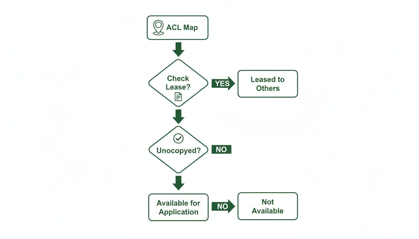
As you can see, it’s a process of layering information. You first identify the land type, then check its lease status, and finally confirm if it's occupied before you even think about setting foot on it.
The Power of Digital Layering
This is where modern digital maps really shine. Instead of flipping between a clunky paper map and a dense, 100-page regulation book, you can see everything you need all in one place. An integrated hunting app, for instance, automatically layers all this critical data right onto your map.
Imagine you're out scouting a new area. With a tool like HuntScout, you can see:
- Crown Land Boundaries: The app clearly outlines where public land begins and private property ends.
- WMU Overlays: Your GPS location is shown right inside the correct WMU boundary, so there's zero guesswork.
- Instant Regulation Access: Just tap on your location, and you can pull up the specific season dates, bag limits, and rules for that exact WMU.
The Critical Advantage: Being able to instantly see your location, know which WMU you're in, and pull up the rules for it is the single biggest leap forward for hunting compliance and safety. It turns a complicated research project into an immediate, in-the-field answer.
Comparing Government Maps with Integrated Hunting Apps
This comparison highlights the key differences and advantages of using a modern hunting app over traditional government-issued maps for in-field use.
| Feature | Official Government Maps | Integrated Hunting App |
|---|---|---|
| Data Layers | Usually shows land ownership only. | Layers Crown land, WMUs, seasons, and more. |
| Real-Time Location | Static; requires a separate GPS to find your spot. | Live GPS tracking shows your exact position on the map. |
| Regulation Access | Requires a separate, often lengthy, regulation book. | Regulations are built-in and accessible with a single tap. |
| Offline Capability | Works offline by nature, but is bulky. | Maps can be saved for offline use, turning your phone into a GPS. |
| Updates | Can become outdated quickly. | Data is updated regularly to reflect changes. |
Ultimately, a modern app just makes the whole process of staying legal and safe incredibly straightforward.
This layered approach helps you avoid the most common and preventable mistakes hunters can make. You can learn more about how to use WMU mapping tools to get the most out of your time in the field. Having that information at your fingertips builds confidence and lets you focus on the hunt itself, not on trying to decipher legal documents while you're out there.
In the end, layering WMU and season data onto your crown land map Manitoba isn't just a nice-to-have feature; it's fundamental to hunting ethically and legally. It ensures that every time you head out, you're not only in the right place but also following the right rules at the right time.
Once you leave the prairie farmland behind, you’re in the real heart of Manitoba’s backcountry: the vast, forested Crown lands. Hunting the sprawling northern boreal and mixed-wood forests is a completely different game—it's more remote, tougher, and for many of us, far more rewarding when you’re after big game like moose, elk, and white-tailed deer.
Getting into this kind of country requires a shift in thinking. It’s not just about finding a chunk of public land on a map. Success out here means learning to read the subtle language of the forest itself. This is where your crown land map manitoba, paired with good satellite imagery, becomes your most powerful tool for spotting the features that pull in wildlife like a magnet.
Think of a mature, old-growth forest like a quiet, established neighbourhood. It’s comfortable, but the pantry is a bit bare. Now, imagine a forest fire or a logging operation has just gone through a section of it. That’s like a brand-new, all-you-can-eat buffet suddenly opening up.
Following the Food to Find the Game
For a hunter, these disturbed areas are pure gold. When a fire or logging opens up the forest canopy, sunlight finally hits the forest floor, triggering an explosion of new growth. Suddenly, there’s a smorgasbord of nutrient-rich browse—young shrubs, grasses, and saplings that big game simply can’t resist.
- Burn Zones: Wildfires are nature's reset button. They clear out the old, dense timber and kickstart the growth of tender, high-protein plants that moose and elk need to thrive.
- Cutblocks and Reforested Areas: Logging operations do something similar, creating what hunters call "edge habitat." Animals feel secure in the standing timber nearby but can easily step into the clearings to feed on the fresh, abundant growth.
When you’re e-scouting from home, these are the signs to hunt for. Satellite views will show the unmistakable patchwork of a recent burn or the sharp, geometric lines of a cutblock. These are your starting points—the places where animals are most likely to be concentrated.
This cycle of renewal and opportunity is a fundamental part of how Manitoba manages its forests. Over a recent five-year period, the province planted over 27 million trees and prepped more than 80,000 hectares for new growth. That’s an average of 5.4 million seedlings a year, constantly creating fresh habitat that’s perfect for a backcountry hunt. You can see the scale of this work for yourself by checking out Manitoba's reforestation efforts on their interactive story map.
Why Navigation Tools Are Non-Negotiable
Pushing deep into forested Crown land presents a serious challenge: it’s incredibly easy to get turned around. Cell service is a luxury you can’t count on, and after a while, every direction can start to look the same. This is where solid navigation becomes a matter of safety, not just convenience.
Safety First: In the backcountry, your map is your lifeline. Trying to rely on memory or a spotty cell signal is a recipe for getting into real trouble. Always, always have a reliable offline navigation plan.
Before you even step out of the truck, you need a system. That means having an app that lets you download detailed offline maps, complete with satellite imagery and your own custom waypoints. Mark potential glassing spots, game trails, and—most importantly—where you parked. By tracking your route as you go, you create a digital breadcrumb trail that will lead you back, even after a long day tracking an animal through thick bush. Without these tools, a hunt of a lifetime can turn into a dangerous ordeal in a hurry.
Planning Your Hunt with Modern Mapping Tools
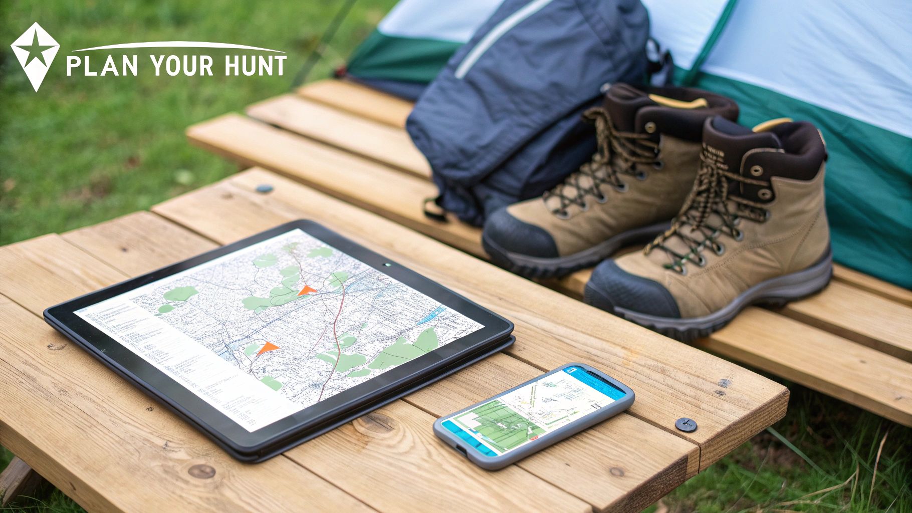
Knowing how to read a crown land map manitoba is half the battle. The other half is turning that information into a solid, actionable plan that puts you in the right place at the right time. This is where modern mapping tools really shine, letting you do the heavy lifting from your couch before you even think about lacing up your boots.
This is what we call “e-scouting.” It’s all about using technology to hunt smarter, not just harder. Think of it as your digital command centre for breaking down the landscape, pinpointing promising spots, and building a strategy before you burn a single drop of fuel. You want to show up on day one with a plan, not just a hunch.
Building Your Digital Hunt Plan
The first step is always a deep dive into satellite imagery. You have to train your eyes to see beyond just green and brown splotches and start recognizing what the land offers the animals you’re after. At its core, you’re looking for the trifecta of survival: food, water, and cover.
Look for terrain features that naturally funnel wildlife or create predictable travel routes. Pay special attention to “edge habitat,” those transitional zones where two different types of terrain meet, like where a forest opens into a meadow. These edges are almost always bursting with life.
Specifically, keep an eye out for:
- Edges of Cutblocks and Burn Areas: As we’ve covered, the fresh growth in these areas is like a dinner bell for deer, moose, and elk.
- Beaver Ponds and Water Sources: Water is a non-negotiable for wildlife, making these spots dependable magnets.
- Saddles and Benches: Animals are efficient. They’ll often use these natural dips and flat spots on ridges as highways to avoid tough climbs.
- Secluded Clearings: Find a hidden meadow tucked away in heavy timber, and you’ve likely found a go-to feeding spot for early mornings and late evenings.
Once you’ve spotted a few of these promising locations, it’s time to start dropping digital waypoints.
From Scouting to In-Field Execution
Waypoints are your digital breadcrumbs. They transform hours of research into a practical guide you can follow on the ground. Instead of wandering into a new area with a vague idea, you’ll have a clear route with specific objectives to check out. A well-placed set of waypoints can make your hunt infinitely more organized and effective.
Pro Tip: Don’t just drop a pin and move on. Give your waypoints descriptive names. "Glassing Knob Overlooking Burn" is a lot more helpful in the heat of the moment than "Waypoint 1." It’s a small detail that helps you remember why you marked that spot in the first place.
A solid waypoint strategy should include pins for:
- Access Points: Mark exactly where you plan to park and the best trail to get from your truck onto Crown land.
- Glassing Locations: Find high points that give you a commanding view of the surrounding country.
- Potential Stand or Blind Sites: Pin spots that overlook game trails, feeding areas, or natural funnels.
- Key Landmarks: Note things like beaver dams, distinct rock slides, or anything that can help you stay oriented.
This kind of detailed planning doesn't just improve your chances of success; it's a huge boost to your safety. For anyone heading into unfamiliar territory, knowing the best hunting apps for Canada is a game-changer, as these tools are designed for exactly this kind of prep.
The final, and arguably most important, step is to plan for the inevitable: losing cell service. The best hunting spots are rarely blessed with good reception. That’s why offline maps aren’t a luxury—they’re an absolute necessity. Before you leave home, make sure you download everything you need: the satellite imagery, Crown land boundaries, and all those waypoints you worked so hard to create. This turns your phone into a reliable GPS unit that will guide you in and out of the backcountry, no matter how far off the grid you go.
Your Manitoba Crown Land Hunting Questions Answered
When you’re out in the bush, questions are bound to pop up. The line between public and private land can get blurry, and figuring out the rules on the spot isn't always easy. This section is designed to give you quick, practical answers to the most common snags hunters run into with a crown land map Manitoba. Think of it as your field guide for making the right call when it matters most.
These are the kinds of problems that can derail a hunt. The goal here is to get you back to focusing on what you're there for, confident you’re on the right side of the law.
Can I Hunt on Any Crown Land in Manitoba?
No, and this is a big one. You can't just assume all Crown land is fair game for hunting. While a massive amount of it is designated as General Use, a lot of parcels are leased out for things like grazing, logging, or other commercial uses. Those leases come with their own access rules. On top of that, you have protected areas like provincial parks and ecological reserves where hunting is almost always a no-go.
This is why having a map that clearly shows these differences is non-negotiable. Modern digital maps are a game-changer here, using simple colour-coding to show you exactly what kind of land you're looking at, often right down to the specific parcel details.
How Do I Know Which WMU I Am In?
Knowing your Wildlife Management Unit (WMU) is absolutely critical. Getting it wrong can mean you're breaking the law. The old-school way is to find your spot on a big paper map and cross-reference it with the official WMU boundary map, but let's be honest—that’s a pain when you’re actually out there.
A much better way is to use a GPS-enabled hunting app on your phone. It pinpoints your exact location and instantly shows you which WMU you're standing in on a live map. It takes all the guesswork out of the equation and keeps you compliant.
What Should I Do If I Lose Cell Service?
Losing your signal isn't a possibility; it's a certainty in many of Manitoba's prime hunting areas. Relying on a live internet connection for your maps is a recipe for disaster. Before you even head out, your top priority should be downloading your maps for offline use.
Crucial Tip: Hunting-specific apps let you save all the important layers—Crown land boundaries, private property lines, satellite imagery, and your own pins—directly to your phone. This means you have full navigation and all your crucial info even when you're completely off-grid, which is a must for safety and a successful trip.
Are Digital Maps as Reliable as Paper Maps?
Absolutely. Reputable digital maps are built on the same official government data that paper maps are. The real advantage they offer is the ability to stack different types of information—like Crown land, private parcels, and WMU zones—all on one interactive screen.
Plus, they get updated way more often than any printed map ever could, so you're seeing the most current land status and regulations. It’s still smart to have a compass and a backup paper map in your pack, but a quality digital tool gives you a level of convenience, accuracy, and real-time information that just makes you a more effective hunter. You get the best of both worlds.
Ready to stop guessing and start hunting with confidence? HuntScout provides the most accurate and easy-to-use Crown land, private property, and WMU maps for Manitoba. Download our app for free and take the guesswork out of your next hunt. Plan your routes, save your spots, and navigate offline. Get started at https://huntscout.app.

