When you're out on the sled, staring at a massive, snow-covered landscape, it's a mix of pure thrill and a healthy dose of intimidation. The excitement of blazing a new trail is real, but so is the challenge of finding your way when every landmark is buried under a blanket of white. This is where a modern GPS isn't just a nice-to-have gadget—it's your lifeline.
Why Your Sled Needs a Modern GPS
Let's face it, the moment you leave the trailhead behind, your phone's cell signal is probably the first thing to disappear. That's the reality for most of the Canadian backcountry. Relying on it for navigation is a gamble you don't want to take.
A good GPS system is your insurance policy. It's the tool that gets you back to the truck, helps you steer clear of unexpected hazards, and keeps you locked on your route, no matter how wild the terrain gets.
Making Sense of Canada's Massive Trail Network
The sheer scale of snowmobiling in this country is staggering. We're talking about a trail network stretching over 112,000 kilometres—one of the biggest in North America. With more than 666,000 registered sleds on the snow and the average rider covering about 2,600 kilometres each winter, knowing where you are is non-negotiable. If you want to dive deeper, the folks at Trakmaps have some great info on just how extensive this network is.
Luckily, today’s navigation tools are way more than just a blinking dot on a screen. They generally fall into three camps, and each has its own place on the trail:
- Dedicated GPS Units: Think of these as the tanks of the navigation world. They're built from the ground up to handle brutal cold, moisture, and the constant rattling of a sled. Best of all, they don't need a cell signal to work.
- Smartphone Apps: An app like HuntScout transforms the phone you already own into a powerhouse navigator. You get high-res satellite imagery, property lines, and killer route-planning tools right in your pocket.
- Helmet HUDs (Heads-Up Displays): This is the high-tech option. It beams directions and map data right into your field of view, so you never have to look down.
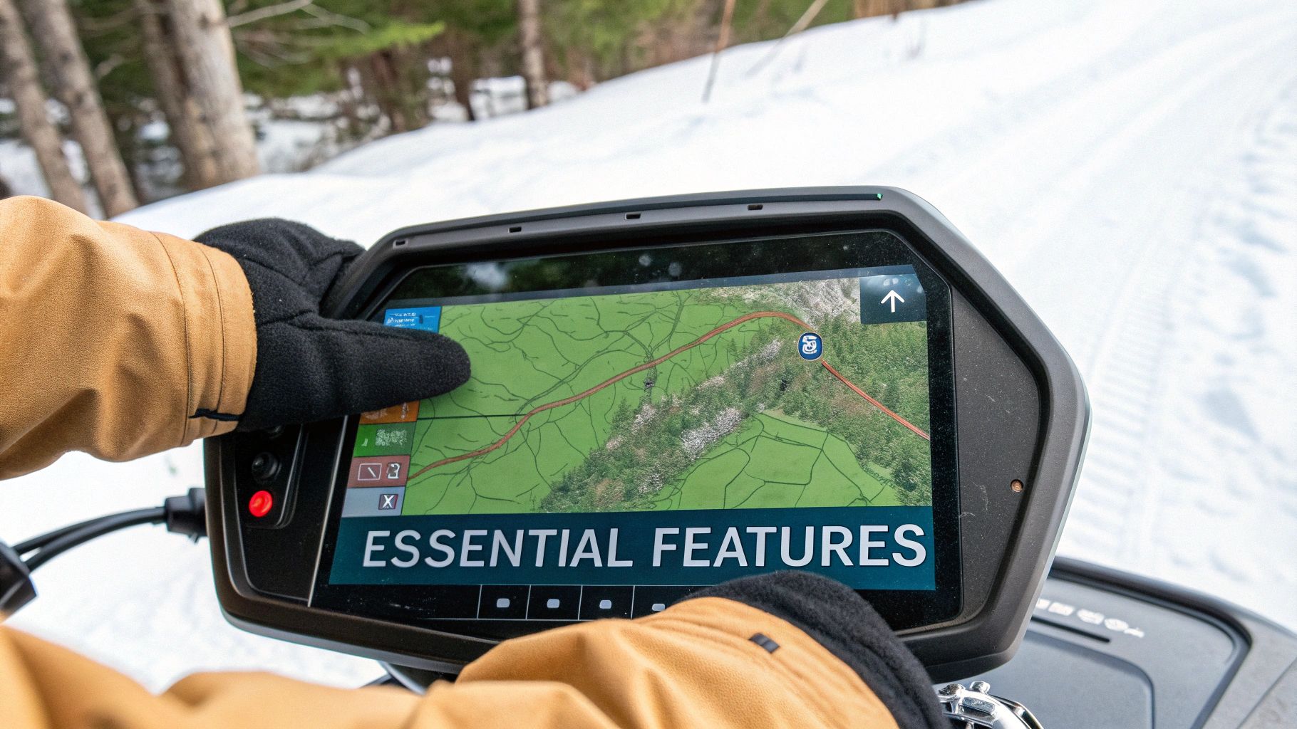
This screenshot from the HuntScout app gives you a taste of what’s possible. It’s not just a map; it's layered with crucial details like Wildlife Management Unit boundaries and private land parcels.
As you can see, a modern GPS app turns a basic map into an indispensable tool for staying on track and on the right side of the law. This guide is all about connecting you with the right tech to make your rides safer and more rewarding, turning that little device into your most trusted partner in the wild.
Dedicated GPS Units Versus Smartphone Apps
When it comes to navigating the backcountry on your sled, you’re faced with a classic debate: should you go with a purpose-built, rugged GPS unit or simply use the powerful smartphone you already own? This isn't just a matter of tech preference. It's a real-world decision that directly impacts your safety, your convenience, and how you experience your ride.
Let's break down the two main camps.
Think of a dedicated GPS unit from a brand like Garmin as the specialist tool in your kit—like a torque wrench that does one job perfectly. These devices are built from the ground up to take a beating. They’re engineered to handle bone-chilling cold, constant vibration, and the inevitable dousing of snow and ice. Most importantly, they work completely independently of any cell service, making them incredibly reliable when you're deep in the Canadian wilderness.
Your smartphone running an app like HuntScout, on the other hand, is the versatile multi-tool. It gives you a brilliant high-resolution screen, a zippy processor, and an interface you're already an expert at using. The biggest advantage here is often the quality of the maps. You get crystal-clear satellite imagery, detailed topographic layers, and powerful integrated data like Crown Land boundaries and WMU maps—a level of detail that many dedicated units just can't match.
So, which is right for you? It really boils down to how and where you ride.
Durability and Real-World Use
Let's be honest: snowmobiling is tough on gear. A dedicated GPS is built for this world. Its housing is shock-resistant and waterproof, often carrying an IPX7 rating, which means it can be fully submerged in water and come out working. The killer feature, though, is the physical buttons. They’re big, tactile, and designed to be used with thick winter gloves—a small detail that feels like a genius move when you’re trying to drop a waypoint in a blizzard.
Smartphones have gotten tougher, but they weren’t born in the backcountry. A simple drop onto an icy trail can easily shatter a screen, taking your primary navigation and communication device out of commission. Plus, their touchscreens are notoriously finicky with gloves, forcing you to pull them off and expose your hands to the cold just to check your map.
A common workaround for the glove issue is using a stylus or gloves with special fingertips. But that just means another piece of gear to keep track of, and it doesn't solve the core problem of a phone's fragility in extreme conditions.
Mapping and Offline Capabilities
This is where the lines start to blur a bit. Dedicated units are the kings of reliability. They come preloaded with base maps and let you add more detailed trail maps, but the display quality can sometimes feel a bit dated. Their job is to get a satellite lock and show you where you are on a map, and they do that job flawlessly, no cell signal required.
Smartphone apps, especially modern ones built for the outdoors, offer a far richer visual experience. With an app like HuntScout, you can download huge areas of high-resolution satellite imagery, topographic maps, and hybrid layers for offline use. This means you can scout a new zone from your couch in stunning detail, then have that exact same map data on your phone when you're miles from the nearest tower. This offline function is what transforms your phone into a true backcountry navigator. To dig deeper, check out our guide on the best hunting apps for Canadian conditions and how they handle off-grid mapping.
This flowchart can help you visualize which path makes the most sense based on where you ride.
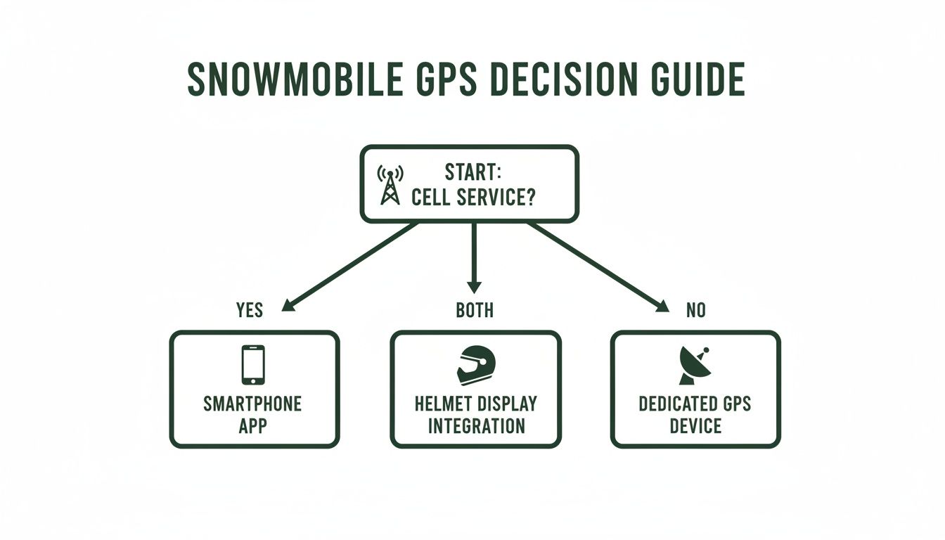
As you can see, the decision really hinges on cell service availability, highlighting the core trade-offs between the two main types of gps systems for snowmobiles.
Battery Life and Power Management
Extreme cold is the enemy of all batteries. The lithium-ion batteries in both smartphones and dedicated GPS units take a serious performance hit as the temperature drops. A phone that lasts all day in your warm pocket might die in just a couple of hours when mounted to your handlebars on a cold day.
Dedicated GPS units usually have a slight advantage here. They are often designed for more efficient power use during constant tracking. The bigger win, however, is that they are designed to be easily hardwired into your snowmobile’s 12V electrical system. This provides a constant, reliable source of power and completely eliminates battery anxiety.
While you can also rig a phone to charge from your sled, it involves a solid mount and a weatherproof charging setup, which adds more potential points of failure. Carrying a portable power bank is always a good backup plan, but it's one more thing to keep charged and protected from the cold.
To help you weigh the pros and cons directly, here’s a side-by-side comparison.
GPS Solution Comparison: Dedicated Unit vs. Smartphone App
| Feature | Dedicated GPS Unit (e.g., Garmin, Ski-Doo) | Smartphone with App (e.g., HuntScout) |
|---|---|---|
| Durability | Excellent. Built to be waterproof, shockproof, and handle extreme cold. | Fair to Good. Relies on a rugged case for protection; vulnerable screen. |
| Glove Use | Excellent. Large, physical buttons designed for gloved hands. | Poor. Touchscreens are difficult or impossible to use with thick gloves. |
| Battery Life | Good. Often has better cold-weather performance and is designed to be hardwired. | Poor. Cold temperatures drain batteries rapidly. Requires a power bank or charging setup. |
| Screen & Maps | Fair. Smaller, lower-resolution screens. Map quality can feel dated. | Excellent. High-resolution display with rich, detailed satellite and topo maps. |
| Offline Reliability | Excellent. Works completely independent of cell service. Core function is offline use. | Excellent (with prep). Requires downloading maps beforehand, but is very reliable offline. |
| Cost | High. Units can cost several hundred dollars, plus potential map subscriptions. | Low. Uses your existing phone. App costs are typically a low yearly subscription. |
| Versatility | Low. Primarily a navigation device. | High. It's also your camera, communication device, and safety tool (with signal). |
Ultimately, the choice comes down to your personal priorities. If you value bombproof reliability and ease of use in the harshest conditions above all else, a dedicated unit is a fantastic investment. If you prefer a richer mapping experience, unmatched versatility, and are willing to take extra steps to protect your device and manage its power, a smartphone with a high-quality app like HuntScout is an incredibly powerful and cost-effective solution.
What Really Matters in a Snowmobile GPS
Picking the right GPS hardware or app is only the first step. The real test of any system isn't the brand name on the box, but how it performs when you're deep in the Canadian backcountry, miles from anywhere. Let's cut through the marketing fluff and talk about the features that actually make a difference on the trail.
These aren’t just nice-to-haves; they are absolutely essential for your safety and the success of your ride, especially when cell service is a distant memory.
Rock-Solid Offline Maps
This is the big one. If your GPS needs an internet connection to work, it’s basically a paperweight the second you lose cell signal. True backcountry navigation requires a system that lets you download detailed maps right onto your device.
Before you even think about loading up the sled, you should be able to save your entire planned route—or even a massive hunting zone—with all the map layers you’ll need. This is your lifeline. It guarantees that no matter how far off the grid you go, you'll see your exact position on a detailed, usable map. Think of it as having a complete set of waterproof topo maps right in your pocket, without the bulk.
Built for the Cold and Rough
Let's be honest: snowmobiling is a tough environment. Your machine vibrates, gets caked in snow and ice, and operates in temperatures that can kill ordinary electronics. Your GPS has to be built for this abuse.
IP Rating: Keep an eye out for a high Ingress Protection (IP) rating. Something like IP67 is what you want. That means it’s totally sealed against dust and can handle being submerged in a metre of water for 30 minutes. That’s peace of mind when you’re dealing with melting snow or an accidental drop.
Temperature Tolerance: Check the specs for the operating temperature range. A lot of consumer-grade gadgets will just give up and shut down in the brutal cold of a Canadian winter, or their batteries will drain in minutes.
Glove-Friendly Controls: This is a surprisingly big deal. Whether it's a dedicated unit with big, chunky buttons or a phone app with oversized on-screen icons, you have to be able to use it with your winter gloves on. Having to pull off a glove in -20°C just to mark a waypoint is more than just uncomfortable—it's a safety risk.
Maps That Tell the Whole Story
A blue dot on a blank screen is useless. For making smart, safe decisions out there, you need maps packed with context about the land around you.
The best GPS setups let you stack and switch between different map layers. For anyone hunting or exploring in Canada, these are non-negotiable:
Topographic Maps: These are crucial for understanding the terrain. The contour lines show you elevation changes, helping you spot steep hills, ravines, and other potential hazards before you get there.
Crown Land Layers: This is vital. Knowing if you're on Crown Land, private property, or in a park is essential for staying legal and respectful. A GPS with reliable land ownership data is the best way to avoid trespassing. If you're riding in Ontario, this is just as important as knowing the ATV trail maps and land access rules in Ontario.
Wildlife Management Unit (WMU) Boundaries: For hunters, this is a game-changer. Seeing the exact WMU boundaries overlaid on your map means you can instantly confirm you’re hunting in the right zone, no guesswork involved.
A great GPS isn't just a map; it's a strategic tool. When you can see your exact location in relation to a creek bed, a steep ridge, or a property line, you can make smarter, safer decisions on the fly.
Smart Waypoint and Route Tools
A good GPS doesn't just show you where you are—it helps you plan your day and retrace your steps.
Waypoints are your digital breadcrumbs. Drop one to mark where you parked the truck, a potential hunting spot, a tricky trail intersection, or a hazard to avoid on the way back. The best systems let you name them and use custom icons, so you can build a personalized map of your favourite zones over time.
Route planning lets you map out your entire trip beforehand by connecting waypoints into a clear plan. Some of the more advanced units even have a "track back" feature that lets you perfectly reverse your route, which is an absolute lifesaver if you get turned around in a sudden whiteout. In fact, this kind of GPS data is now even helping trail maintenance crews create colour-coded maps showing riders which trails have been freshly groomed. You can learn more about how snow groomer fleet tracking is changing the sport and improving rides for everyone.
Using HuntScout for Backcountry Hunting Success
Your smartphone can be much more than just a phone; it can be one of the most powerful hunting and navigation tools you own. With an app like HuntScout, that device in your pocket becomes a specialized piece of gear for safely tracking your way through the Canadian backcountry on a snowmobile. It’s all about using the tech you’ve already got to plan smarter and ride with real confidence.
The secret to turning your phone into one of the best GPS systems for snowmobiles is all in the prep work. Your trip doesn't start when you fire up the sled. It starts at home, on your couch, using the app to scout terrain, mark key spots, and—most critically—download your maps for offline use. This is the single most important step. It guarantees your phone will keep you on track, even when you’re miles from the nearest cell tower.
Planning Your Hunt from Home
A successful backcountry hunt is almost always the result of a solid plan. The detailed satellite imagery and map layers inside HuntScout let you do all your recon from a computer or phone, which saves a ton of time and energy once you're out in the field.
Think of this pre-trip phase as your virtual scouting mission. You can explore your entire hunting area, looking for promising features like clearings, frozen creek beds, or the kind of dense cover that holds game. The high-resolution satellite view gives you a perspective that old-school paper maps just can't compete with, helping you spot potential glassing points or the perfect place for a setup.
Before you even think about loading the sled, knock out these critical steps:
- Define Your Area: Zero in on your hunting zone, especially the specific Wildlife Management Unit (WMU) you have a tag for.
- Download Offline Maps: This is absolutely non-negotiable. Select your entire WMU or planned route and download the maps straight to your phone. This makes sure every layer—satellite, topographic, and land ownership—is ready to go without a cell signal.
- Drop Key Waypoints: Mark your essential locations before you head out. This means your base camp, where you'll park the truck, trailheads, and any of those promising spots you found while digital scouting. Give them simple, clear names like "Truck Parking" or "Ridge Overlook" so you know what's what at a glance.
Pro Tip: Always download more than one map layer for your area. A satellite layer is fantastic for visual reference, but a topographic layer is what you'll need to truly understand the elevation changes and steepness of the terrain you're about to tackle.
Navigating with Confidence in the Field
Once you're out on the snow, all that prep work really starts to pay off. With your offline maps loaded, your phone acts just like a dedicated GPS unit, showing your live location on a detailed map. This is where an app truly shines, pulling together all the crucial information you need into one simple, easy-to-read screen.
As you ride, you can add to your map on the fly by dropping new waypoints. See fresh animal tracks or rubs? Mark it. Find a perfect lookout you want to hit again later? Drop a pin. This turns your map from a simple navigation aid into a living, breathing log of your hunt.
The integrated land ownership data is another game-changer. With a quick tap on the screen, you can see instantly if you're on Crown Land, private property, or inside a park boundary. This takes all the guesswork out of the equation, so you can hunt legally and ethically without ever worrying about accidentally trespassing. You can get more details on how the app breaks down Canadian hunting regulations on the official HuntScout website.
Using Advanced App Features
Modern hunting apps offer a lot more than just a dot on a map. Features like an integrated AI Assistant can be incredibly handy, even when you're completely off-grid. Let's say you're out in your WMU and can't remember a specific local regulation. You can just ask the AI Assistant for the answer without needing a signal, because that critical data is already stored inside the app.
It’s this combination of detailed planning, bulletproof offline maps, and smart in-the-field tools that makes a smartphone with HuntScout such a powerful setup. It helps you navigate with certainty, make smarter decisions, and ultimately, lets you focus on what you came to do—have a safe and successful backcountry hunt.
Mounting and Powering Your GPS System
Even the fanciest GPS is just dead weight if its battery dies or it flies off into a snowdrift. The real-world reliability of your navigation setup boils down to two simple things: how it's mounted and how it stays powered. Get these two details right, and your tech will be as tough and dependable as your sled.
Think about it—the constant vibration and jarring impacts of trail riding will expose any weak point in a mount. A flimsy setup is just asking for a lost or shattered device, potentially leaving you stranded without a map. What you're aiming for is a rock-solid mount that also puts the screen right where you can see it with a quick glance.
Choosing the Right Mounting Solution
The core principles are the same whether you're using a dedicated GPS unit or your smartphone in a rugged case. You need a system that clamps the device down and can handle the rough-and-tumble reality of snowmobiling.
Here are a few of the most effective and trail-tested options:
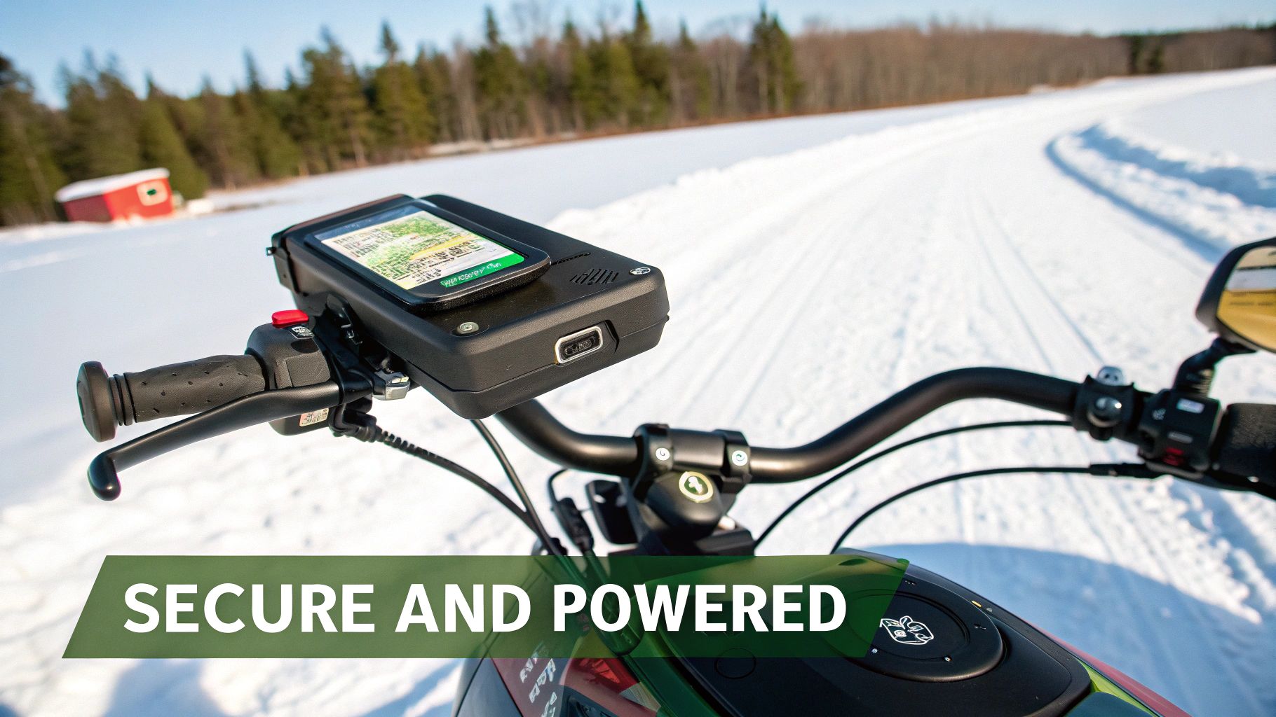
Handlebar Clamps: There's a reason these are the go-to. They bolt directly to your handlebars, putting the screen in your natural line of sight. Make sure you get one made from metal, not cheap plastic, and look for rubber or silicone inserts that help absorb some of the chatter.
Secure Cradles: This is the piece that actually grabs your device. The best ones feature a spring-loaded or locking mechanism that gives your GPS or phone a death grip. For phones, a cradle that secures all four corners is worlds better than a simple magnetic or friction-grip mount that can fail on a hard hit.
RAM Mounts: This brand is practically synonymous with powersports mounts. Their genius is the ball-and-socket design; it gives you nearly endless adjustment possibilities but locks down incredibly tight, resisting vibrations like nothing else.
The sweet spot for placement is somewhere you can see the screen without having to look completely away from the trail. Don't mount it so low that your gear blocks it, or so high that it's the first thing to get smashed in a rollover.
A solid mount is half the battle. Keeping it powered is the other.
Solving the Backcountry Power Problem
Extreme cold is the arch-nemesis of batteries. A phone that lasts all day in your warm pocket can die in an hour or two when it's exposed to frigid air on your handlebars. This makes a reliable power source an absolute must-have for any serious backcountry rider.
The best fix is to tap right into your snowmobile’s electrical system. This gives you a constant, steady charge that completely eliminates battery anxiety.
Here’s how to make sure you never run out of juice:
Hardwire a Charger: Most sleds have a 12V accessory port or a battery you can wire into. Installing a weatherproof USB or 12V socket is a pretty straightforward job that provides unlimited power. This is, by far, the most bulletproof option for keeping both dedicated units and smartphones topped up.
Use a Powered Mount: Some higher-end dedicated GPS units come with a powered cradle. This integrates the power connection right into the mount itself, creating a clean, weatherproof system that starts charging the second you click the device into place.
Carry a Backup Power Bank: Even if you're hardwired, a portable power bank is cheap insurance. Just be sure to keep it tucked in an inside pocket where your body heat keeps it from freezing. A good 10,000mAh power bank can recharge a modern smartphone a few times over, giving you a critical safety net if something goes wrong.
A little preventative maintenance goes a long way, too. Always make sure charging ports are clean and dry before you plug anything in, and use the rubber caps or covers to keep out snow and ice. A small investment in a quality mount and a solid power source is what turns your GPS from a neat gadget into a piece of essential survival gear.
Staying Safe with GPS and Emergency Tools
Think of your GPS as more than just a map. It’s the cornerstone of your entire backcountry safety system. Sure, it's brilliant for getting you from A to B, but its real power is unlocked when you integrate it into a smart, responsible plan for every trip. Using it properly can be the difference between a funny story about getting turned around and a life-threatening emergency.
One of the best habits you can ever form is sharing your trip plan. Every single time. Before you even thumb the throttle, make sure a trusted contact back home has your route, your key waypoints, and your expected return time. This simple act creates a crucial safety net, giving search and rescue a massive head start if you're overdue.
Sharing Your Plan for Peace of Mind
Modern apps like HuntScout make this ridiculously easy. You can map out your entire day—from the truck to base camp to your hunting spots—and share it in a few taps.
- Export Your Route: Send a GPX file or a screenshot of your intended path.
- List Key Waypoints: Give them the exact coordinates for your truck, your camp, or any other critical locations.
- Set a Check-In Time: Agree on a hard deadline for when you'll call or text to say you're safe.
This isn't just good advice; it's a proven lifesaver. A detailed plan can shrink a massive search area down to a manageable size, potentially cutting response time from days to just a few hours.
Integrating with Emergency Communicators
Let's be real: even the most meticulous plan can go sideways. That’s why you'll see most seasoned sledders pairing their GPS systems for snowmobiles with a dedicated satellite messenger or a Personal Locator Beacon (PLB). Devices like the Garmin inReach are built to work where your phone is just a paperweight.
Your GPS tells you exactly where you are, and the satellite device lets you tell someone else when you need help. It's a powerful one-two punch. If you get hurt or your machine breaks down miles from anywhere, you can send an SOS with your precise coordinates, ensuring help comes right to you.
A GPS tells you where you are. A satellite communicator tells others where you are when you're in trouble. Together, they turn a solo rider into a connected and much safer adventurer.
Staying Legal and Respectful
Finally, your GPS is your best friend for staying on the right side of the law and respecting property owners. In Canada, you absolutely must know whose land you're on. A good GPS loaded with up-to-date land ownership layers is your only real defence against accidental trespassing, which can come with stiff fines and lost privileges.
For hunters, the stakes are even higher. Having Wildlife Management Unit (WMU) boundaries layered onto your map takes all the guesswork out of staying in your zone. Apps like HuntScout put this information right at your fingertips, making your GPS not just a tool for finding your way, but a partner in responsible, legal, and ethical backcountry travel.
Common Questions from the Trail
Getting your navigation setup dialled in for sledding brings up a few common questions. Let's tackle the big ones so you can ride with confidence, knowing your gear is ready for anything.
Can I Just Use My Phone Without Cell Service?
You absolutely can, and this is a game-changer. It’s a common myth that your phone's GPS needs a cell signal to work. In reality, the GPS chip in your phone talks directly to satellites, a process that doesn't use your data or cellular network at all.
The catch is, you need to prepare ahead of time. Before you lose service, you must download offline maps for your entire riding zone using an app like HuntScout. If you don't, your phone can still find your location, but it will just be a lonely blue dot floating on a blank grey screen—not much help when you're trying to find your way back.
Will the Cold Kill My Battery?
Yes, without a doubt. Extreme cold is the arch-nemesis of all batteries, whether they're in a dedicated GPS or your smartphone. A phone that gives you a full day of use at room temperature might die in just an hour when it's exposed to the elements on your handlebars.
The best way around this is to hardwire your device directly to your snowmobile’s 12V electrical system. This gives you a constant, reliable power source. If that’s not an option, your next best bet is to carry a fully charged portable power bank tucked away in a warm inside pocket—it's a critical piece of backup gear.
Are Dedicated GPS Units Still Worth It?
For a lot of serious riders, they're still the gold standard. While a phone running a powerful app gives you incredible mapping and features, dedicated GPS units are built from the ground up for one thing: to survive in the harshest conditions imaginable.
They win on a few key points: they're typically bombproof, have much better resistance to water and shocks, and—most importantly—they have physical buttons. Trying to use a touchscreen with thick, cold winter gloves on is frustrating, but mashing a big button is easy. If rugged reliability is your top priority, a dedicated GPS is a fantastic investment that you can always count on.
Ready to turn your phone into the ultimate backcountry tool? With detailed offline maps, Crown Land layers, and WMU boundaries, HuntScout gives you the confidence to explore Canada's wild spaces safely. Download HuntScout on the App Store today.

