Before you even think about buying a tag, checking season dates, or lacing up your boots, your entire Ontario hunt hinges on one thing: knowing your Wildlife Management Unit (WMU).
Think of it this way: Ontario is a massive, diverse landscape, and you can't manage wildlife in the southern farmlands the same way you manage it in the boreal forest up north. WMUs are how the province is divided into distinct zones, each with its own specific set of hunting regulations. Getting this right isn't just a suggestion—it's the foundation for a legal, ethical, and successful hunt.
Why Your Ontario Hunt Starts with a WMU Map
Knowing your WMU is step zero. It comes before everything else. These units are the building blocks for all of Ontario’s hunting regulations, designed to manage wildlife populations sustainably across wildly different ecosystems.
A WMU isn't just an arbitrary line drawn on a map; it's a critical management tool. The rules for hunting deer in the agricultural fields of WMU 92B, for example, are worlds apart from the regulations for a moose hunt in the dense, remote forests of WMU 1C. If you don't know which unit you're standing in, you're essentially guessing at the rules, and that can lead to serious penalties.
The Purpose of a WMU
The Ministry of Natural Resources and Forestry (MNRF) created the WMU system to manage wildlife on a local level. This allows them to make smart, data-driven decisions based on what's actually happening on the ground in a specific area—things like animal populations, habitat quality, and hunter success rates.
The main goals are pretty straightforward:
- Sustainable Harvests: Making sure that hunting pressure doesn't harm the long-term health of any species.
- Hunter Opportunity: Providing fair and accessible hunting opportunities for everyone, no matter where they are in the province.
- Data Collection: Gathering key information from each unit to make better conservation decisions down the road.
Every successful hunt begins with a simple question: "Which WMU am I in?" Answering this correctly is the single most important step in complying with Ontario's hunting regulations and ensuring a responsible and ethical experience.
This guide will walk you through everything you need to know about using an Ontario WMU map. We'll cover everything from finding your unit with the government's own tools to using modern apps like HuntScout to plan your entire season with confidence.
What Exactly Is a Wildlife Management Unit?
Think of a Wildlife Management Unit, or WMU, as a specific neighbourhood designed for wildlife conservation. Ontario is a massive province with incredibly diverse landscapes, so a one-size-fits-all approach to hunting regulations just wouldn't work. The Ministry of Natural Resources and Forestry (MNRF) created these zones to manage animal populations in a way that makes sense for each local area.
These aren't just random lines on a map. WMU boundaries are drawn based on real-world factors like deer population density, the type of habitat available, and even long-term hunter data. This scientific approach ensures the rules for the farmlands of Southern Ontario are different from those in the dense Boreal forests up north, as they should be.
At its core, the entire system is about keeping wildlife populations healthy for the long haul. Each WMU allows the MNRF to fine-tune hunting seasons, decide how many tags are available, and set harvest rules that match the biological reality on the ground in that specific zone.
The Science Behind the Boundaries
So, why not just have one set of rules for the whole province? It’s pretty simple: the deer herd in WMU 92B near Lake Erie lives in a completely different world than the deer in WMU 60 near Algonquin Park. They face different environmental pressures and have different carrying capacities. By creating these management zones, conservation becomes much more targeted and effective.
This scientific foundation is the "why" behind the whole thing. It turns a simple wmu map ontario from a bunch of lines into a powerful conservation tool. Each unit is treated like its own ecosystem for management, which lets officials make precise adjustments to hunting rules whenever they're needed.
A WMU is more than just a hunting zone; it's a carefully defined area where science-based conservation meets practical wildlife management. Knowing your unit is the first step to becoming an ethical and informed hunter.
A Framework for Sustainable Hunting
This system is what makes ethical, sustainable hunting possible in Ontario. The WMUs provide the essential framework for regulating big game hunting, breaking the province down into zones that are tailored to local deer populations and their habitats. And it works. This data-driven approach has helped stabilize herds, with buck-to-doe ratios improving 12% province-wide since 2015. You can dig into more of these deer harvest trends over at OODMag.com.
Ultimately, the WMU system gives hunters a clear and predictable set of rules. Once you’ve pinpointed your unit on a map, you unlock all the information you need for a safe and legal hunt:
- Season Dates: When you can legally be out there hunting a specific species.
- Bag Limits: How many animals you’re allowed to harvest.
- Tag Requirements: The exact tags you need to have for that unit.
- Weapon Restrictions: Any specific rules about the types of firearms or bows you can use.
Without this structure, managing Ontario's vast wildlife resources would be chaotic at best. It’s the system that strikes the critical balance between conservation and our passion for hunting.
Getting Your Bearings with Official Government WMU Maps
When you need the definitive, official source for WMU boundaries, your first stop is always the Ontario government. The primary tool they offer is the Ministry of Natural Resources and Forestry’s (MNRF) Make-a-Map: Hunting application. It's a powerful, interactive map designed to let you find and view any WMU across the province.
Now, while it's the official source of truth, I'll be honest—many hunters (myself included) find it can be slow and a bit clunky to use, especially when you're on a phone out in the bush. Still, knowing how to use it is a fundamental skill.
How to Navigate the Make-a-Map Tool
Using the Make-a-Map application boils down to a few basic steps. Your goal is to get the WMU boundaries showing on the map and then find your specific hunting area.
- Turn on the WMU Layer: After the map opens, look for the "Map Layers" menu. You have to find and check the box for "Wildlife Management Units" to make the boundaries appear on the map.
- Find Your Hunting Area: The easiest way is to use the search bar for a town or landmark near your spot. Otherwise, you can just pan and zoom around the map manually.
- Pinpoint Your Unit: Once you zoom in, the coloured WMU boundaries will become sharp and clear. Just click inside one of the coloured zones, and a little pop-up box will appear telling you the exact WMU number.
This is what you'll see when you first load up the Make-a-Map tool, before you've selected any layers.
It’s just a basic map of Ontario at first; it's up to you to add the layers you need.
If you're like me and don't trust cell service where you hunt, the MNRF also has you covered. They offer downloadable PDF maps for every single WMU. These are perfect for printing out a hard copy or just saving to your phone for offline access.
The Bottom Line: The government's Make-a-Map tool works well enough for planning at your desk, but its sluggish performance and clunky mobile design can be a real headache for hunters needing quick answers in the field.
The Reality of Using Official Tools
Let's be real: just because a tool is "official" doesn't mean it's user-friendly. Hunters often run into slow load times, a confusing interface that hides information behind too many clicks, and just plain awful performance on a mobile browser. This isn't just an annoyance; it can become a real problem when you're on the move and need to quickly confirm if you're about to cross a boundary line.
These frustrations are exactly why many hunters look for more modern, streamlined mapping solutions. If you're interested in exploring some better alternatives, you can learn more about how to find your WMU in our detailed guide.
Decoding Your WMU Map for a Successful Hunt
Knowing your WMU number is just the first step. To really plan a smart, successful hunt, you need to understand what all those lines, colours, and symbols on your wmu map ontario actually mean. This is where you turn a simple map into a powerful field strategy.
Think of it like this: the map is your playbook. Those boundaries aren't just random lines drawn by a bureaucrat; they usually follow real, tangible features on the ground—a highway, a concession road, a river, or even a hydro corridor. Knowing this is critical. If you cross one of those features without realizing it, you could easily wander into a different unit where the season dates, bag limits, and even legal firearms are completely different.
This visual guide breaks down the basic process for zeroing in on your unit with a digital map, which is the starting point for digging into the details.
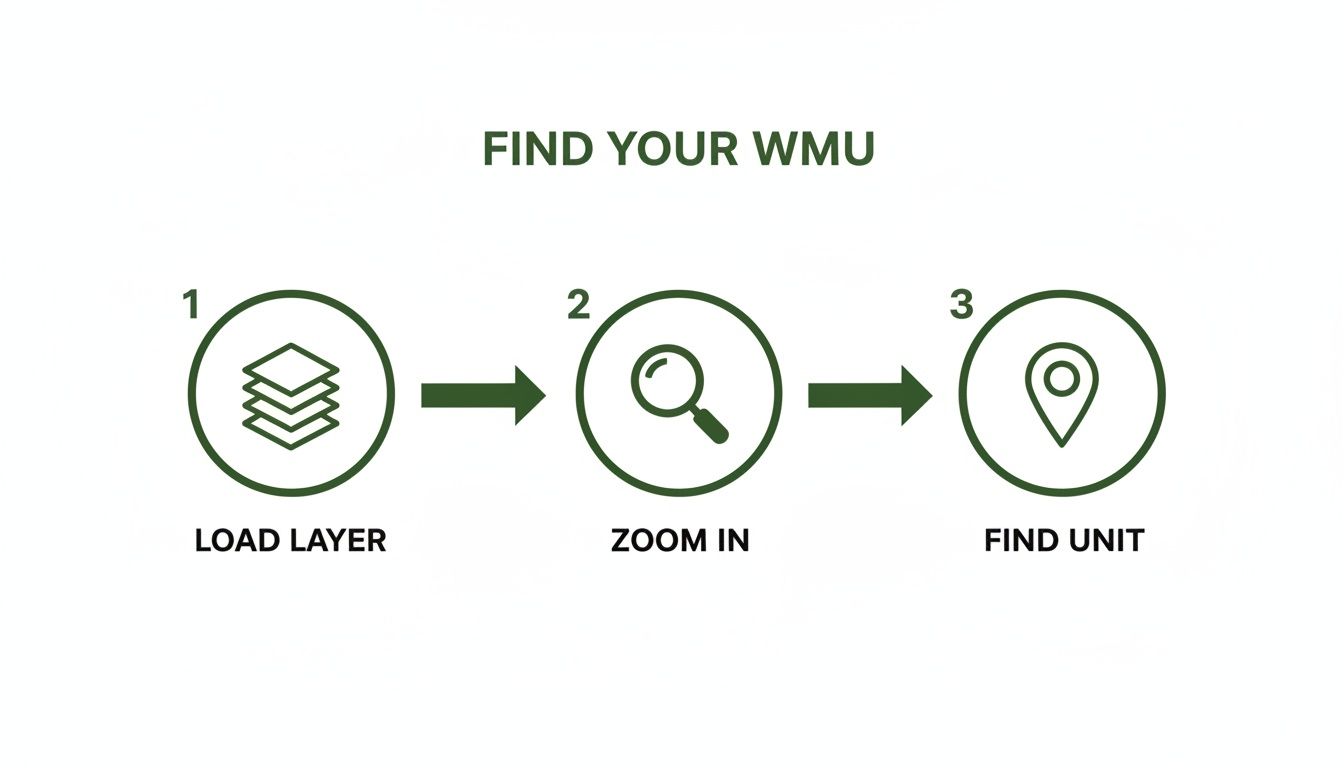
This simple three-step flow—load the right layer, zoom in, and find your unit—is the foundation of any good digital hunt plan.
Looking Beyond the Boundaries
A detailed WMU map gives you so much more than just the unit number. It’s layered with other critical information that can make or break your hunt. You need to keep an eye out for specific overlays or notes that dictate what you can and can't do.
Pay close attention to details like these:
- Sunday Gun Hunting Areas: Not every municipality in Ontario allows Sunday gun hunting. A good map will show you exactly which areas do and which don’t.
- Firearm Restrictions: Some units, especially in the more populated parts of southern Ontario, have tight restrictions. You might find areas that are shotgun and muzzleloader only, with no centre-fire rifles allowed.
- Baiting Regulations: Depending on the WMU, there can be specific rules about where and when you can set up bait for species like deer or bear.
Missing one of these details can quickly turn a great day in the woods into a frustrating—and potentially illegal—one. The map is your first line of defence against these simple but costly mistakes.
The real magic happens when you cross-reference your WMU map with the official Hunting Regulations Summary. The map shows you where you are; the summary tells you what you can legally do there.
A Real-World Planning Example
Let’s walk through how this works in practice. Say you're planning a deer hunt in WMU 76. You’ve pulled up the map, found your unit, and traced the boundaries. Your next move is to open the official Hunting Regulations Summary and flip to the section for WMU 76.
There, you'll find the specific season dates for archery, muzzleloader, and rifle hunts. You’ll also see the bag limits and confirm exactly which tags you need. By taking this simple step, your map goes from being a navigation tool to the cornerstone of your entire hunt plan.
For moose hunters, this process is even more crucial. The province has 76 moose-designated WMUs, but resident tags are only offered in 69 of them. An outfitter planning a trip in WMU 65, for example, might use offline WMU maps to overlay boundaries on satellite imagery. This allows them to mark General Use Areas versus restricted zones—an absolute lifesaver when you're deep in the bush and cell service is a distant memory. This level of detail, explored in research on moose management strategies, is what ensures every hunt is both legal and strategic.
How the HuntScout App Simplifies WMU Mapping
Let's be honest, trying to make sense of a slow government website or a clunky PDF map on your phone while you're out in the bush is a recipe for frustration. It’s a common headache for hunters, but this is exactly where a good, modern tool can make all the difference.
The HuntScout app was designed to cut through that confusion. It takes all the guesswork out of an Ontario WMU map by putting everything you need right at your fingertips.
Instead of flipping between different websites and files, HuntScout overlays sharp, easy-to-read WMU boundaries directly onto satellite and topographic maps. Having that immediate visual context is a total game-changer. You can see exactly how a boundary follows a specific river, cuts across a field, or runs along a ridge, giving you a real-world understanding of where you are.
Instant Answers in the Field
The app is built for speed and simplicity. Just tap anywhere on the map, and HuntScout instantly tells you which WMU you're standing in. No more second-guessing when you're working a boundary line—you get a quick, confident answer right when you need it.
But it does more than just show you where you are. It brings all the critical planning information together in one place. Key features that make your hunt easier include:
- Integrated Season Dates: You can see the relevant season dates for your WMU without ever leaving the map screen.
- Clear Crown Land Layers: The app makes it incredibly easy to see the difference between Crown land and private property.
- Offline Map Functionality: Before you even leave home, you can download all the maps for your hunting area. This means you have full access to everything, even when you're deep in the backcountry with zero cell service.
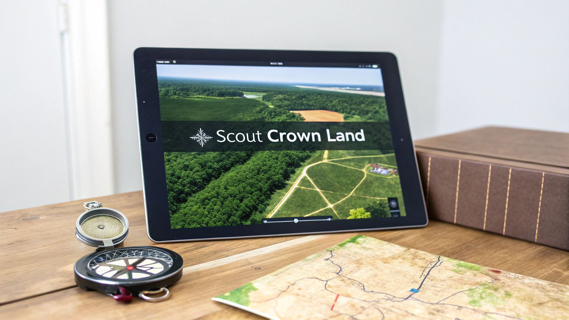
This screenshot gives you a good idea of how HuntScout puts WMU and Crown Land data right on top of a satellite map, giving you a complete picture.
The colour-coding for different land types and the bold WMU borders let you understand your surroundings with just a quick glance.
The real advantage of using an app like HuntScout is that it bundles navigation, regulation boundaries, and land access information into one reliable tool. It’s built for the specific challenges Ontario hunters face.
For anyone planning a hunt in a remote area, having offline access is non-negotiable. When you consider that 87% of Ontario is Crown Land—and most of that is in the north where cell service is spotty at best—this feature becomes absolutely essential. It ensures your detailed wmu map ontario works perfectly when you need it most.
By bringing these tools together, you spend less time wrestling with technology and more time focused on the hunt itself. For more insights on this topic, check out our guide on the best hunting apps in Canada.
Advanced Hunt Planning: Combining WMU and Crown Land Maps
Knowing your WMU keeps you on the right side of the law, but the real secret to becoming a more strategic hunter is layering that knowledge with Crown Land data. This is where you graduate from simply following the rules to actively using map information to stack the odds in your favour. A modern wmu map ontario tool truly shines when it shows you not just where the boundaries are, but where you can actually hunt within them.
Think about it: an incredible 87% of Ontario is Crown Land. The sheer scale of opportunity is mind-boggling, but finding a good, accessible hunting spot can feel impossible. This is precisely why combining WMU boundaries with clear Crown Land layers is a game-changer. It instantly cuts through the noise, showing you exactly where the big, huntable tracts of public land are located inside the unit you want to hunt.
Digital Scouting on Public Land
Once you’ve zeroed in on your target WMU and highlighted the public land within it, the real scouting begins—and you can do most of it from your couch. This is where you use high-resolution satellite imagery to dissect the terrain and pinpoint the little features that attract and hold game. It’s about working smarter, not harder, so you’re not wasting precious time in the field wandering aimlessly.
The goal here is to find the key habitat features that dictate how animals move and behave. By poring over the satellite view, you can start to pick out:
- Natural Funnels: Look for those obvious pinch points. I’m talking about saddles between ridges, narrow creek crossings, or thin strips of bush connecting two bigger woodlots. These are the spots that naturally funnel deer and other game, making them ideal ambush locations.
- Food and Cover: Scan for potential food sources. These could be clear-cuts with fresh browse, farm field edges butting up against Crown Land, or a good stand of mature oaks. Once you find the food, look for the nastiest, thickest cover nearby—that’s where they’ll be bedding down.
- Access Routes: Map out your entry and exit strategy by tracing old logging roads, ATV trails, or even waterways. A quiet approach that doesn’t blow every animal out of the county is just as critical as picking the perfect tree.
This kind of deep dive turns a simple map into a full-blown, three-dimensional hunting strategy.
A WMU map tells you the rules of the game. A Crown Land map shows you the playing field. Combining them with satellite imagery lets you write the playbook for a successful hunt.
From Screen to Field
By carefully dropping waypoints on these potential hotspots in an app like HuntScout, you’re building a personalized library of well-researched locations to check out on foot. When you finally lace up your boots, you’re not just hoping to get lucky; you’re executing a plan based on real intel. This method saves an incredible amount of time and lets you focus your energy on the areas with the highest potential.
This strategic layering of information is the core of modern hunting. To get into the nitty-gritty of public land access, check out our in-depth guide on hunting Crown Land in Ontario. It’s the perfect next read to help turn your digital scouting into a punched tag.
Common Questions About Ontario WMU Maps
Once you start digging into WMU maps, a few practical questions always seem to pop up, especially when you’re out in the bush trying to figure out where you stand. Let's tackle some of the most common ones hunters ask about using a wmu map ontario.
How Accurate Are the WMU Boundaries?
This is a big one. Are the lines I see on the map the absolute, final word? For the most part, yes. WMU boundaries are pretty stable and don't get redrawn every year.
But—and this is important—the Ministry of Natural Resources and Forestry (MNRF) can and does make adjustments based on wildlife population studies or conservation efforts. The golden rule is to always double-check the latest official Hunting Regulations Summary before the season kicks off. That's where any official changes will be announced.
What If a Boundary Isn't a Clear Landmark?
It's one thing when a WMU boundary follows a highway or a river, but what happens when it’s just an invisible line cutting through the middle of the woods? How do you know if you’ve crossed it?
This is exactly where a GPS-enabled app becomes indispensable. A tool like HuntScout uses your phone's GPS to pinpoint your exact location on the map, showing you precisely how close you are to that boundary line. It takes all the guesswork out of staying on the right side.
How Do I Use Maps Without Cell Service?
"What happens when I lose my signal?" Every hunter who's ventured off the beaten path knows this is a critical concern. Relying on a live internet connection in the backcountry is just asking for trouble.
This is why offline maps are a non-negotiable piece of gear. Before you even think about heading out, you need to download the maps for your WMU onto your phone. This saves all the essential layers—boundaries, topography, private and Crown land—directly to your device.
That way, your map and GPS location will work perfectly whether you have five bars of service or zero. It’s the modern-day equivalent of a well-worn paper map, but with the huge advantage of a little blue dot that tells you exactly where you are. Skipping this step isn't an option for a safe and successful hunt.
Stop guessing and start scouting with confidence. HuntScout gives you clear WMU boundaries, Crown Land layers, and powerful offline maps built for the Canadian hunter. Download the app and plan your next successful hunt today.

