The short answer? Yes, you can absolutely hunt on huge portions of Ontario's Crown land.
With a staggering 87% of the province classified as Crown land, we're talking about millions of acres of wild, untamed backcountry open to licensed hunters. The real trick isn't just knowing it's there; it's knowing how to find the right spots and navigate the specific rules that come with them.
Your Adventure into Ontario's Vast Backcountry
For a lot of hunters, the thought of tackling Crown land feels like trying to piece together a massive puzzle without the box top. The sheer scale can be daunting. The fear of accidentally stepping over an invisible property line or breaking some obscure rule is enough to keep many people from even trying.
But what if you could trade that uncertainty for a confident, repeatable plan for your next adventure?
Think of Crown land less like a tangled legal map and more like Ontario's shared public backyard—a massive expanse just waiting to be explored. This guide is your key to that backyard. We're going to break down the entire process, starting with the basics and moving step-by-step into practical, on-the-ground strategies. My goal is simple: give you the knowledge and tools you need to find your own secluded hunting spots, legally and safely.
This isn't about just reciting regulations. It's about building a real-world skillset. You'll learn how to:
- Tell the difference between huntable "General Use Areas" and off-limits zones.
- Use modern digital mapping tools to e-scout promising terrain from your couch.
- Understand the critical link between Crown land boundaries and Wildlife Management Units (WMUs).
- Put together a solid plan for access, navigation, and most importantly, safety.
A Legacy of Conservation on Public Lands
The way we manage wildlife on these public lands has a long and storied history. Take the Peterborough Crown Game Preserve, for example. It was established way back in 1927 to help bring back struggling deer populations around the Bancroft area.
For decades, hunting was completely off-limits across these vast tracts of Crown land, giving the deer a chance to recover. By the 1970s, tagging programs confirmed that the strategy worked—most deer stayed within the preserve's boundaries. It was a powerful demonstration of how targeted management on public land can have a massive impact. You can read more about the history of the game preserve to appreciate its long-term effects.
This conservation mindset continues today, ensuring that opportunities to hunt Crown land in Ontario will be there for generations to come.
The Big Picture: Ontario has more than 39 million hectares of managed Crown land in its central and northern regions alone. To put that in perspective, that's an area larger than Germany, filled with forests, lakes, and incredible hunting opportunities just waiting for you.
Crown Land Hunting Quick Start Checklist
Before you pack your gear and head for the woods, it's smart to have a clear game plan. Think of these as the essential first steps for any hunter starting their Crown land journey in Ontario. This checklist covers the absolute must-dos to ensure your hunt is legal, safe, and built on a solid foundation of good research.
| Step | Key Action | Why It's Important |
|---|---|---|
| 1. Get Licensed | Obtain a valid Ontario Outdoors Card and all required hunting licences and tags for your target species and season. | This is the non-negotiable legal starting point. Without the right paperwork, you can't hunt anywhere, let alone on Crown land. |
| 2. Know Your WMU | Identify the Wildlife Management Unit (WMU) you plan to hunt in and review the specific seasons, bag limits, and regulations. | All hunting in Ontario is governed by WMU rules. Crown land is just the location; the WMU rules are the law of the hunt. |
| 3. Access the Atlas | Familiarize yourself with the Crown Land Use Policy Atlas (CLUPA). This is your primary tool. | CLUPA is the official source for identifying General Use Areas, private land in-holdings, and restricted zones like provincial parks. |
| 4. Plan Your Access | Use CLUPA and satellite maps to identify legal access points, such as public roads, trails, or waterways. | Just because it's Crown land doesn't mean you can get to it. Finding legal, practical access is often the biggest challenge. |
| 5. Go Offline | Download offline maps of your chosen area to your phone or GPS device. | Cell service is unreliable or non-existent in most Crown land areas. Offline maps are a critical safety and navigation tool. |
Nailing these five steps will set you up for success and prevent the most common mistakes hunters make when exploring public land. Once you've got this foundation, you can dive deeper into scouting, gear, and strategy.
What Every Hunter Must Know About Crown Land
Think of Ontario's Crown land not as one big, open park, but more like a massive public backyard with different zones, each with its own set of house rules. Getting a handle on these rules is the absolute first step to a successful—and legal—hunt. It all comes down to learning the language of the land.
The whole system is built around what the government calls "land use designations." Some areas are wide open for recreation like hunting, while others are set aside for conservation or leased out for commercial use like logging or mining. Getting this part wrong is a surefire way to end your trip with a fine instead of a filled tag.
Honestly, your entire journey into hunting Crown land Ontario hinges on your ability to tell these different types of public land apart. It's the foundation for everything else you'll plan.
The Key Difference: General Use vs. Restricted Areas
The most important term you need to burn into your memory is General Use Area. This is basically the green light for hunters. These are vast tracts of Crown land where activities like hunting, fishing, and camping are generally good to go, as long as you're following all the provincial hunting regulations.
On the flip side, you have restricted lands. This category includes places like provincial parks, conservation reserves, and other special management zones. In these spots, hunting is almost always off-limits. Mistaking a conservation reserve for a General Use Area is one of the most common and costly mistakes a hunter can make.
The Golden Rule of Crown Land: Always assume a piece of land is off-limits until you can definitively prove it is a General Use Area. This simple shift in mindset will prevent 99% of common mistakes and keep you on the right side of the law.
Your Rights and Responsibilities as a Hunter
Having access to millions of acres of public land is an incredible privilege, and it comes with some serious responsibilities. Just because you're on Crown land doesn't mean it's a free-for-all. The rules are there to protect the land, the wildlife, and everyone else who wants to enjoy it.
For instance, while you can camp for up to 21 days in one spot each year, you can't go building permanent structures. That means no permanent tree stands, cabins, or shelters. The principle is simple: whatever you bring in with you, you must be prepared to pack out.
Here’s a look at the official Ontario government page for Crown land, which lays out many of these core rules and points you to key resources.
This page is a great starting point, connecting you to critical tools like the Crown Land Use Policy Atlas (CLUPA), which we’ll get into in a bit.
Understanding your obligations is just as important as knowing your rights. Respect is the name of the game. This means respecting:
- The Land: Pack out everything you pack in. Leave your campsite cleaner than you found it.
- The Wildlife: Hunt ethically and follow all WMU regulations for seasons, tags, and bag limits.
- Other People: Crown land is a shared space. You might run into hikers, campers, or other hunters. Be courteous, and always make safety your top priority.
Navigating Access and Leased Land
One of the biggest headaches when hunting Crown land in Ontario is simply getting to it. You might find what looks like the perfect block of General Use land on a map, only to drive out there and discover it's completely landlocked by private property with no legal way in.
It is your responsibility to make sure your access route is legal. Never cross private land without getting explicit permission from the landowner first—even if it looks like an old, overgrown trail. That's trespassing, and it can land you in serious trouble.
On top of that, some Crown land is leased out to individuals or companies for things like logging, trapping, or mining. While it's technically still public land, the leaseholder has specific rights that you absolutely must respect.
- You must get permission from the leaseholder to hunt on their leased area.
- You cannot camp on leased Crown land without their say-so.
Forgetting to do your homework on access and leases can turn a promising hunt into a frustrating dead end before it even starts. If you want to dig deeper into this, our guide on finding Ontario Crown lands to hunt breaks down mapping and access strategies in more detail.
Finding and Accessing Huntable Crown Land
Alright, now that we've covered the rules of the road for Crown land, it's time to get down to business. This is where the real hunt begins—not in the bush, but on your computer or phone. Honestly, learning how to find and access good hunting spots from home is the single most valuable skill you can develop for hunting Crown land in Ontario.
This "e-scouting" is your secret weapon. It saves you an incredible amount of time, money, and boot leather. Before you even burn a litre of gas, you can rule out unproductive areas and zero in on spots that have real potential. The goal here is to build a solid list of Plan A, B, and even C locations to check out in person.
Starting with the Official Source: The CLUPA
Your first port of call should always be the government's official tool: the Crown Land Use Policy Atlas (CLUPA). Think of CLUPA as the ultimate legal authority, the official map that shows what you can and can't do on every parcel of Crown land in central and northern Ontario. It's the definitive source for telling you if a spot is a General Use Area (good to go for hunting) or a restricted zone like a conservation reserve.
Using CLUPA isn't optional; it's essential for confirming the legal status of any piece of land you're considering. But here's the catch: it was never designed for hunters in the field. Its main job is to display policy reports and land designations. The interface can feel clunky, it's missing the detailed satellite views we need, and it’s definitely not built for navigating on your phone when you're deep in the backcountry with spotty service.
Key Takeaway: Use CLUPA to legally verify that a spot is a General Use Area. Once you have that confirmation, switch to a more modern, hunter-friendly mapping tool to do your detailed scouting and in-field navigating.
Getting from a general idea to a confirmed, huntable spot is a pretty straightforward process. It's all about a sequence of checks to make sure you're playing by the rules.
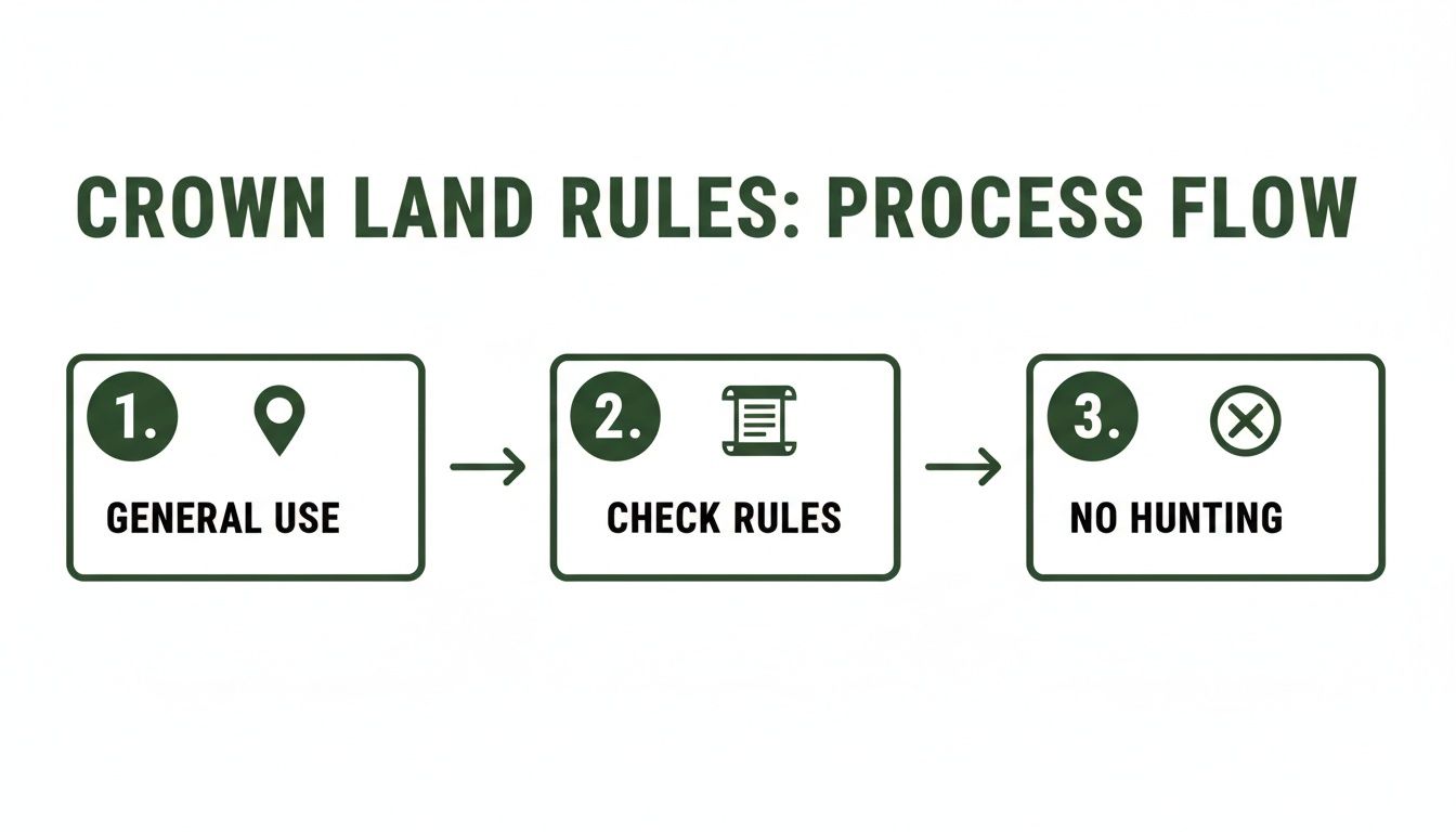
This workflow hammers home a critical point: finding General Use land is just the first step. You always have to dig into the specific rules for that area before you even think about putting boots on the ground.
Modern Mapping Tools: The Hunter’s Advantage
This is where specialized hunting apps completely change the game. Platforms like HuntScout take all that foundational data from sources like CLUPA and overlay it onto beautiful, high-resolution satellite maps. Then they add all the other critical layers a hunter actually needs.
Suddenly, you’ve got everything you need in one place:
- Crown Land Boundaries: See the exact lines where public land ends and private property begins. No more guessing.
- WMU Overlays: Instantly know which Wildlife Management Unit you’re in, so you can check the correct season dates and regulations.
- Satellite and Topo Maps: Switch between views to analyze the terrain, find clearings, spot water sources, and see every ridge and valley.
- Access Roads and Trails: Uncover potential entry points, from well-travelled logging roads to faint two-tracks you’d never see on a basic map.
This all-in-one approach transforms a flat, confusing map into a powerful three-dimensional scouting tool. You can practically read the land from your living room.
To make an informed choice, it's helpful to see how the main options stack up. Each tool has its place, but for serious e-scouting and in-field navigation, a dedicated hunting app is hard to beat.
Comparing Crown Land Mapping Tools
| Tool | Best For | Key Features | Limitations |
|---|---|---|---|
| CLUPA | Legal verification | The definitive source for official land use policies and designations. | Clunky interface, no offline mode, lacks satellite imagery and hunting-specific layers. |
| HuntScout App | E-scouting & in-field navigation | Integrates Crown land, WMUs, topo, satellite, private land, and offline maps. | Subscription-based for premium features. Requires a smartphone. |
| Physical Maps | Backup & big picture planning | Reliable with no batteries required. Good for seeing a large area at a glance. | Easily damaged, lacks real-time location, requires compass skills, can be outdated. |
While government resources like CLUPA are essential for initial verification and paper maps make for a great backup, a modern app is what brings it all together, turning data into a true strategic advantage for the hunter.
Your E-Scouting Workflow
With a good mapping app fired up, you can begin your search. The secret is to stop thinking like a human and start thinking like the animal you're after. What does a deer or a moose need? Food, water, and cover. Your job is to find where those three ingredients overlap inside the boundaries of huntable Crown land.
Step 1: Identify Large Tracts of General Use Land Start big. Scan your target WMU for those huge, continuous blocks of Crown land. In most apps, these will be coloured light green or yellow. Larger tracts are often better because they give you more space to get away from roads and hunting pressure.
Step 2: Pinpoint Key Terrain Features Now, zoom in and start looking for the good stuff. Drop waypoints on your map to mark:
- Edges and Transitions: Pay close attention to where thick bush meets a recent logging cut or an open beaver meadow. Deer love to travel these edges.
- Water Sources: Find those hidden beaver ponds, meandering creeks, and swampy areas. They are magnets for all kinds of wildlife.
- Natural Funnels: Look for terrain that squeezes animal movement into a predictable path, like a saddle between two ridges or a narrow strip of high ground through a wetland.
- Potential Glassing Spots: Mark any high points or clear-cuts that could give you a great vantage point to sit and watch the surrounding area.
Step 3: Find the Access You’ve found some killer-looking spots. Great. Now, how do you get there? Trace logging roads, trails, and hydro lines back from the nearest highway. Look for pull-offs or small clearings where you can safely and legally park your vehicle. Always double-check that your entire route is on public land. For those with a quad, this is also the perfect time to explore the vast trail network by looking at an Ontario ATV trails map, which can open up a ton of hidden access points.
By following a digital scouting process like this, you take the overwhelming task of searching millions of acres and turn it into a focused, strategic plan. You'll show up on opening day with a handful of high-percentage spots, a few backups, and the confidence that only comes from doing your homework.
Understanding WMUs and Ontario Hunting Seasons
So you’ve found a promising piece of Crown land. It feels like you've hit the jackpot, but hold on—you’ve only cleared the first hurdle. The land itself is just the where. The Wildlife Management Unit (WMU) it sits in determines the what, when, and how of your hunt.
Think of Ontario's landscape as being divided into dozens of unique hunting "neighbourhoods," each with its own set of bylaws. These are the WMUs. A beautiful stretch of moose country in WMU 28 might have completely different rules, dates, and bag limits than a seemingly identical piece of forest just a few kilometres down the road in WMU 40.
Getting this wrong is a surefire way to ruin a trip and land you some serious fines. The specific WMU of your chosen spot dictates everything from the species you can legally pursue to the type of firearm you can carry.
Pinpointing Your Exact WMU
Your first job is to figure out exactly which WMU you'll be hunting in. Guessing won't cut it. The boundaries between units can be invisible lines—a small creek, a property line, or an old survey marker. Being off by a few hundred metres could put you in the wrong unit, making your hunt illegal from the start.
This is where a good digital mapping tool becomes your best friend. Modern hunting apps layer the precise WMU boundaries right over satellite and topographic maps. You can just drop a pin on your spot and instantly see which unit you’re in. It takes all the guesswork out of the equation. Our guide on using an Ontario hunting WMU map dives deeper into how these tools can streamline your planning.
Once you know your WMU, it’s time to hit the books—the official Ontario Hunting Regulations Summary.
Navigating the Hunting Regulations Summary
The Ontario Hunting Regulations Summary is the ultimate source of truth. You need to consult it every single year, because season dates, bag limits, and even the WMU boundaries themselves can and do change. The summary is organized by WMU, so you can quickly zero in on the rules for your specific "neighbourhood."
The government's official hunting notices page is where you'll find the most up-to-date links to the full regulations summary.
Bookmark this page. It’s your direct line to the most current information and will keep you in the loop on any last-minute changes before you head into the field.
When you're looking at the rules for your WMU, you need to lock down a few key details:
- Open Seasons: Check the exact dates for your target species. Pay close attention to different seasons for bows, muzzleloaders, and rifles, as they often don't overlap.
- Bag Limits: Know precisely how many animals you can legally harvest.
- Specific Rules: Some WMUs have unique restrictions, like antler requirements for deer or limitations on certain types of firearms. Don't assume the rules are the same everywhere.
Hunter's Pro Tip: Don't just glance at the regulations once. Download a PDF copy to your phone and keep a printed version in your truck or pack. That way, you’ll have the rules on hand even when you're deep in the bush with zero cell service.
Why This System Matters
This isn’t just about bureaucracy. The WMU system is a cornerstone of modern wildlife conservation. It allows biologists to manage animal populations on a very local level, ensuring herds are healthy and sustainable for generations to come.
Take white-tailed deer, for example. Ontario's Crown lands are a huge draw for deer hunters, and the province tracks the data from each WMU meticulously. In peak years between 2009 and 2023, the number of active deer hunters often ranged from 100,000 to 120,000. In a strong season like 2013, the total harvest across the province topped 80,000 deer, with bucks making up over 40,000 of that number.
This kind of detailed data, broken down by WMU, helps biologists make smart decisions. They can adjust season lengths or the number of tags available to respond directly to population trends in a specific area, keeping the entire ecosystem in balance. You can explore more of this official harvest data yourself to see how your favourite spots are trending.
Your Pre-Hunt Scouting and Safety Plan
A successful hunt on Crown land is almost never about luck. It’s born from solid preparation that starts long before opening day, bridging the gap between your digital maps and the boots-on-the-ground reality of the Ontario backcountry. Your e-scouting has given you a list of potential hotspots; now it's time to verify them in person and build a rock-solid safety plan.
This phase is about much more than just looking for game. It's about building the confidence to step into remote areas safely and respectfully. A well-planned scouting trip confirms what you saw on the screen, reveals critical details no satellite can show, and makes sure you have a reliable plan for getting in and out without a hitch.
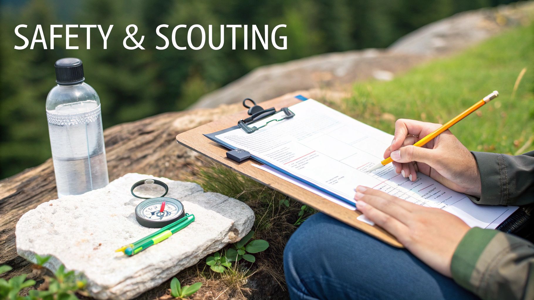
Your Boots-on-the-Ground Scouting Checklist
Digital maps are fantastic for flagging promising areas, but they don't tell the whole story. An in-person visit is where you confirm access, find fresh sign, and start to truly understand the lay of the land. It’s your chance to turn a waypoint on a screen into a real, workable hunting strategy.
Your main goal here is to find recent, active signs of whatever you're hunting. Here’s what to zero in on:
- Game Trails: Look for well-worn paths cutting through the undergrowth. Pay close attention to where multiple trails intersect—these can be incredible spots for a stand or blind.
- Bedding Areas: Find that thick, nasty cover, like dense conifers or a tangled mess of deadfall, where deer or moose feel safe. Locating these sanctuaries is key to figuring out their daily patterns.
- Food and Water Sources: Identify what’s being eaten right now. That could be an oak ridge dropping acorns, fresh browse on young saplings, or a beaver pond with lush greens. Water is always a major draw.
- Natural Funnels: It's time to confirm those terrain features you marked on your map. Walk the saddles between ridges and the high ground through swamps to see if animals are actually using them as travel corridors.
This physical confirmation is priceless. It helps you rank your spots and build a game plan for different wind directions and times of day.
Building Your Backcountry Safety Protocol
When you venture into remote Crown land, you are your own first responder. Cell service is a luxury, not a guarantee. A bulletproof safety plan isn't just a good idea; it's a non-negotiable part of responsible hunting on Crown land in Ontario.
Your plan should be simple, effective, and shared with someone you trust.
The Hunter's Lifeline: Before you even leave the driveway, always give a responsible person your detailed hunt plan. This needs to include your exact parking location (GPS coordinates are best), your intended hunting area, and your expected return time. If you don't check in by that time, they know to call for help.
This simple act is one of the most critical safety steps you can take. It’s what ensures that if something goes wrong, a search will be initiated.
Mastering Off-Grid Navigation
Your smartphone is an incredible navigation tool, but it's only as good as its battery and its signal. Before heading out, you absolutely must download offline maps of your entire hunting area using a reliable app like HuntScout. This saves all the satellite imagery and property boundaries directly onto your device.
With offline maps, your phone's GPS will continue to show your precise location on the map even with zero bars of service. This lets you:
- Track Your Path: See exactly where you've walked, making it easy to retrace your steps back to the truck, even in the dark.
- Mark Key Waypoints: Drop pins on your parking spot, glassing knobs, fresh rubs, or the spot where you harvest your animal.
- Navigate with Confidence: Move through the woods knowing exactly where you are in relation to your waypoints and property lines.
Always carry a backup power bank for your phone. Better yet, have a traditional compass and a physical map of the area in your pack. They're essential backups that never run out of batteries, and knowing how to use them is a fundamental backcountry skill.
The Leave-No-Trace Ethic
Finally, remember that Crown land is a shared treasure. The privilege of hunting these wild places comes with the responsibility to leave them better than you found them. Pack out everything you pack in—that means spent casings, food wrappers, and every last piece of your gear.
This Leave No Trace principle ensures the land stays wild and accessible for the next generation of hunters, hikers, and anglers. It’s all about respecting the land, the wildlife, and the other people who cherish these incredible public spaces.
Common Questions About Hunting Ontario Crown Land
As you get deeper into planning your Crown land hunt, a lot of specific questions start to pop up. It's totally normal. You can have the best plan in the world, but those "what if" scenarios will always creep in. Let's tackle some of the most common ones I hear from hunters heading out into Ontario's backcountry.
The goal here is to give you direct, clear answers so you can head out with confidence. Think of this as a final check on the most important details for a safe and successful trip.
Can I Camp on Crown Land While I'm Hunting?
Yes, you absolutely can! This is honestly one of the greatest perks of hunting Crown land in Ontario. As a Canadian citizen or eligible resident, you’re allowed to camp for free on most general-use Crown land for up to 21 days in one spot per year. It's a game-changer for those multi-day hunts deep in the bush.
But it’s not a free-for-all. You can't build any kind of permanent structure—so no busting out the hammer and nails. The rule of thumb is to practice leave-no-trace camping. That means everything you bring in with you, you bring out. Every last scrap of garbage.
A couple of other crucial points: make sure your campsite doesn't block any roads or trails. Other people need to get through. And before you even think about setting up, you must double-check the land designation on the Crown Land Use Policy Atlas (CLUPA) or a good hunting app. Camping is a big no-no in conservation reserves and other restricted areas. And always, always check for local fire bans before you even dream of a campfire.
How Should I Handle Running Into Other People?
You will almost certainly run into other people out there. Crown land is a shared space, so expect to see hikers, anglers, bird watchers, and of course, other hunters. The key to making these encounters positive is simple: courtesy and safety.
If you spot someone, make your presence known from a safe distance in a calm, clear voice. Your firearm should, as always, be pointed in a safe direction. Be ready for a friendly chat; they might just be curious about what you're doing. A quick, polite explanation that you're hunting legally in the area usually does the trick.
A Shared Space Mentality: Just remember, their right to be there is the same as yours. A respectful, professional attitude goes a long way. It prevents conflicts, makes the entire hunting community look good, and ensures everyone can enjoy these incredible public lands safely.
What's the Best Way to Navigate Without Cell Service?
Counting on your phone's internet connection for navigation in the backcountry is a recipe for disaster. The single most reliable method these days is a modern hunting app that has solid offline mapping features.
Before you lose service, you need to download the maps for your entire hunting area right onto your phone. This saves all the important layers—satellite imagery, topo lines, Crown land boundaries, and WMU zones—directly to your device. Once that's done, your phone's built-in GPS will show your exact location on those maps, even with zero bars of service.
This setup lets you confidently:
- Track where you've been in real-time.
- Mark and navigate to waypoints (like your truck, a good glassing spot, or your campsite).
- Always find your way back.
Even with this tech, I can't stress this enough: carry a traditional map and compass as a backup. More importantly, know how to use them. Technology can fail, but a compass always points north.
Are ATVs Allowed for Accessing Crown Land?
Generally, yes. ATVs, side-by-sides, and snowmobiles can be fantastic tools for getting into remote hunting spots. That said, their use is governed by some pretty strict rules meant to protect the land.
You have to stick to existing, established trails. Ripping a new trail through the bush or tearing through sensitive areas like wetlands and shorelines is illegal and can land you some serious fines. It's just not worth it. Plus, some specific Crown land areas might have their own restrictions or be closed to motorized vehicles altogether.
It’s your job to check the CLUPA and look for any local signs for specific rules. And make sure your machine is properly registered and insured. If you’re on a maintained trail system, you’ll likely need the right trail pass, like one from the OFATV. Using your ATV responsibly is key to protecting the habitat and making sure we all get to keep this privilege.
At HuntScout, we're all about helping you have safer, more successful Canadian hunting adventures. Our app gives you detailed Crown land maps, WMU boundaries, and the offline navigation you need to take the guesswork out of planning. Download HuntScout today and hunt with confidence: https://huntscout.app

