So, you're looking for an Ontario ATV trails map. The first thing you need to realize is that there isn't just one. Ontario's trails are a massive, incredible patchwork of interconnected systems, and each piece is often managed by a different group with its own set of rules and permits.
Understanding Ontario's ATV Trail Landscape
Before you can even think about finding the right map, you have to get a handle on how this all fits together. Don't picture a single, unified highway system. It’s more like a collection of regional and local road networks—all vital, but they serve different areas and almost always require separate passes for legal access.
This is a critical distinction, especially if you're a hunter. The organized trail that gets you close to your hunting spot might be managed by a club, but that smaller, unmarked path leading deep into a Wildlife Management Unit (WMU) is likely on Crown land. Knowing the difference is absolutely essential for a successful—and legal—trip. If you're planning on venturing off the beaten path, you can learn more about navigating these areas in our complete guide to Ontario Crown Lands.
The Major Trail Organizations
Most of the designated ATV trails in Ontario fall under the care of two main types of groups: provincial federations and local clubs. The federations are the big-picture players, coordinating everything, handling permit systems, and providing resources across huge regions.
A perfect example is the Ontario Federation of All-Terrain Vehicles (OFATV). It’s the backbone for trails stretching from Windsor all the way to Ottawa, supporting 18 member clubs that do the hard work of maintaining and expanding the routes you ride. Their QuadOn app is a game-changer, giving riders real-time trail status and route planning features. It's an indispensable tool for planning any serious trip. For more info on Ontario's ATV trail federations and their mapping tools, Destination Ontario is a fantastic resource.
Expert Tip: Think of a trail pass as more than just a fee. It's your ticket to well-maintained trails and, just as importantly, the exclusive, up-to-date maps that come with them. Before you head out, always double-check which permit you need for the specific area you plan to ride.
Comparing Major Ontario ATV Trail Systems
To give you a clearer picture, here's a quick breakdown of the major players managing the trail networks across the province.
Major Ontario ATV Trail Systems at a Glance
| Trail System | Governing Body | Primary Region | Key Feature |
|---|---|---|---|
| OFATV Trail Network | Ontario Federation of All-Terrain Vehicles (OFATV) | Southern, Central, and Eastern Ontario | Extensive, interconnected network with real-time status via the QuadOn app. |
| EOTA Trail Network | Eastern Ontario Trails Alliance (EOTA) | Eastern Ontario | Multi-use trails (ATV, snowmobile, hiking) often following old railway lines. |
| HATVA/KATVA | Haliburton/Kawartha ATV Association | The Kawarthas & Haliburton Highlands | Massive and scenic trail systems known for their challenging and varied terrain. |
| V-TAG | Voyageur Multi-Use Trail System | Mattawa-Bonfield region | Inter-provincial connection, linking to Quebec's vast trail network. |
Each of these organizations provides an incredible riding experience, but knowing which one operates where you want to go is the first step in getting the right map and permit.
Crown Land vs. Managed Trails
Riding on club trails is one thing; venturing onto Crown land is a whole different ball game. The organized trails are marked, maintained, and generally easy to follow. Crown land, on the other hand, is the wild west of ATVing. You're often dealing with unmaintained access roads, old logging routes, or informal trails.
It’s an amazing way to access remote hunting grounds, but it comes with a lot more responsibility.
- Managed Trails: These are clearly marked, regularly maintained, and always require a permit. The maps are usually provided directly by the club or federation in charge.
- Crown Land Routes: These are often unmarked, unmaintained, and can be unpredictable. Navigation here isn't about following a club map; it's about using tools like HuntScout that can overlay property data onto satellite maps to show you where you are and what’s permissible.
Getting this distinction straight is the foundation for building a complete mapping strategy that works for any adventure you can dream up.
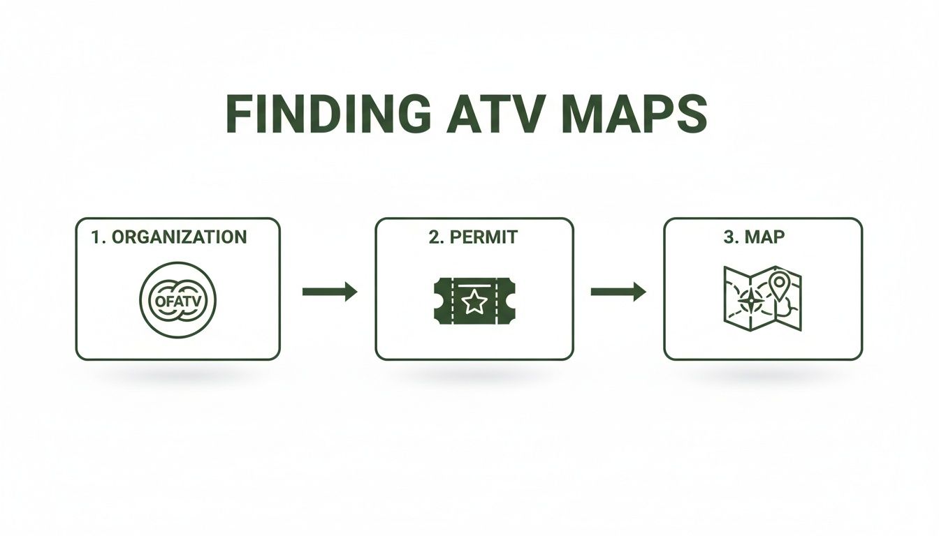
Looking for an Ontario ATV trails map? Don't just fire up a search engine and hope for the best. That’s a quick way to find outdated forum posts and sketchy downloads that could lead you into trouble. The only maps you should trust are the ones that come straight from the source—the clubs and organizations that actually build and maintain the trails.
The best way to get these maps is usually tied to buying a trail pass. Think of your permit as more than just a ticket to ride; it's your key to a whole library of verified, up-to-date mapping data. Organizations like the Ontario Federation of All-Terrain Vehicles (OFATV) and regional groups like Algonquin Trail Ventures Ontario (ATVO) invest a ton of time and money into grooming trails and mapping them precisely. When you buy a pass, you're directly supporting that work and getting access to their exclusive digital maps in return.
Start with the Major Federations
Your first stop should always be the main organization for the area you want to explore. They provide the big-picture view of their entire network, which is the perfect place to start planning.
- Ontario Federation of All-Terrain Vehicles (OFATV): If you're riding in most of Southern or Central Ontario, the OFATV is your go-to. Buying one of their permits gives you access to the fantastic QuadOn app. It’s an interactive map showing real-time trail status, points of interest, and even routing—essential for navigating their massive, interconnected system.
- Algonquin Trail Ventures Ontario (ATVO): This group manages thousands of kilometres of trails, stretching from the Kawarthas all the way north towards Cochrane. Their website is the official spot to grab a trail pass and the mapping information that goes with it, which details their five distinct trail ‘nodes’.
Starting with these federations is like looking at a provincial highway map before you zoom in on the local roads. It gives you the lay of the land so you can see how everything connects.
The single biggest mistake riders make is relying on a generic map found online. These are often years old and fail to show critical updates like recent washouts, logging activity, or permanent reroutes. Always go to the official source—your safety depends on it.
Drill Down to Local Club Websites
Once you've got the overview, it's time to zoom in. The real gems are found at the local level. The individual clubs operating under the big federations are the ones with their boots on the ground, and their websites are goldmines for the kind of detailed, local knowledge you won't find anywhere else.
For example, a club like the Haliburton ATV Association (HATVA) or the Kawartha ATV Association (KATVA) will have maps specific to their turf. These are packed with the details you actually need out on the trail:
- Difficult Sections: They'll point out trails that are especially rocky, muddy, or technical.
- Staging Areas: Find the best and safest spots to park your truck and trailer.
- Local Points of Interest: Discover scenic lookouts, rider-friendly diners, and nearby gas stations.
- Recent Closures: Get the latest news on temporary trail closures from storm damage or maintenance work.
Finding these local clubs is easy. If you plan on riding near Bancroft, a quick search for "Bancroft ATV club" will take you right where you need to go. Their maps, often available as downloadable PDFs or on an interactive webpage, give you the confidence to plan a safe and memorable trip.
Choosing the Right Digital Maps and GPS Tools
When you're deep in the bush, miles from the nearest cell tower, your map is more than a convenience—it's your lifeline. Picking the right digital tools before you leave is just as critical as packing a first-aid kit. The best Ontario ATV trails map really depends on what you're trying to accomplish that day.
Dedicated trail apps are fantastic for straightforward navigation on a specific network. The OFATV's QuadOn app, for example, is brilliant for navigating their trails. It’s purpose-built for that system, giving you real-time updates on trail conditions and closures, and it does that one job exceptionally well.
But for a lot of us, especially hunters, the real adventure often begins where the marked trail ends. That's when more versatile mapping platforms become absolutely essential.
Beyond Basic Navigation Apps
This is where powerful, multi-layered mapping tools like HuntScout really shine. They let you stack different types of crucial data to get the full picture. You can start with a high-resolution satellite base map, then overlay the official ATV trail network right on top. That’s useful on its own, but the real magic happens when you start adding more layers.
With a few taps, you can throw on the WMU boundaries to see exactly which unit you're standing in. Next, add the Crown Land layer to instantly confirm if you have legal access to hunt where you plan to stop. All of a sudden, your map isn't just showing you how to get somewhere; it's telling you what you can legally do once you get there. For a deeper dive, you can check out our detailed guide on how to effectively use ATV trail maps in Ontario.
The process for getting official map access usually starts with supporting the clubs that build and maintain the trails you ride on.
As you can see, getting the best, most up-to-date maps starts with getting a permit. It's how the whole system keeps running.
Mastering Offline Maps and GPX Files
Out in prime Ontario ATV country, cell service is a luxury, not a guarantee. This is non-negotiable: any mapping tool you rely on must have rock-solid offline capabilities. Before you lose that last bar of signal, you need to download the map sections for your entire planned riding area. This saves all the satellite imagery, trail data, and property boundaries right to your device, ensuring your GPS keeps working perfectly without an internet connection.
Another incredibly useful feature to look for is the ability to import GPX files. A GPX file is just a standard format for GPS data—think of it as a digital breadcrumb trail containing routes, tracks, and waypoints. Many local ATV clubs will offer GPX files of their specific trail systems for download on their websites.
Pro Tip: Before any big trip, I make it a habit to hunt down the local club's GPX file and import it into my main mapping app. This often reveals small, unmapped side trails or local points of interest that aren't on the big, federated maps. It gives me a much more detailed and accurate picture of what's actually on the ground.
This simple step can turn your smartphone or a dedicated GPS unit like a Garmin into a customized navigation powerhouse. You get the boots-on-the-ground accuracy from the local club, combined with all the powerful features of your preferred mapping app.
For instance, the Eastern Ontario Trail Alliance (EOTA) manages a massive multi-use network spanning roughly 690 km from Lake Ontario all the way to Algonquin Park. For a hunter, these trails are a gateway to prime Crown land, and integrating a local GPX file with HuntScout's high-res maps makes it easy to see exactly where you can legally and safely venture off-trail.
Digital ATV Mapping Tool Comparison
With several options available, choosing the right digital tool can be tough. The table below breaks down some popular choices to help you decide which platform best fits your needs, whether you're a casual trail rider, a serious hunter, or both.
| Tool | Primary Function | Offline Capability | Hunting Layers (WMU/Crown Land) | Best For |
|---|---|---|---|---|
| HuntScout | Multi-layer mapping for hunting & outdoors | Yes, full offline functionality | Yes, comprehensive and integrated | Hunters who use ATVs for access and scouting. |
| QuadOn | Official OFATV trail navigation | Yes, for OFATV network only | No | OFATV members needing real-time trail status. |
| Garmin GPS | Dedicated hardware GPS navigation | Yes, requires pre-loaded maps (e.g., Topo) | Limited, requires separate map products | Riders who prefer a rugged, dedicated device. |
| Avenza Maps | Georeferenced PDF map viewer | Yes, based on downloaded PDF maps | Varies by map publisher | Accessing specific PDF maps from clubs or gov't. |
Each tool has its strengths. A dedicated app like QuadOn is perfect for its intended purpose, but for those of us who need to see beyond the trail itself, a more robust, layer-based platform like HuntScout is often the smarter choice.
Putting It All Together: From Trail Map to Hunt Plan
For any serious hunter, an ontario atv trails map isn't just about getting from A to B. It’s a game-changer. When you start layering it with other critical hunting data, you transform a simple trail network into a strategic plan for a smarter, more successful hunt—all before your boots even hit the ground.
Let's imagine a practical scenario. You're looking to scout a new piece of land for deer in Central Ontario. The first thing you'll probably do is open a mapping app like HuntScout and browse the Wildlife Management Units (WMUs). Maybe you've heard good things about WMU 57, a huge unit with a great mix of forest, swamps, and ridges. It looks promising.
But before you even think about trails, you have to know if you can legally be there. This is where the magic happens. With a single tap, you can overlay the Crown Land data layer. The map instantly lights up, showing you exactly which areas are General Use Crown Land—fair game for hunting and riding—and which are private tracts you absolutely need to steer clear of.
Charting a Course with Certainty
Okay, so you've confirmed your hunting grounds. Now, how do you get into the best spots? This is where you bring in the ATV trail map layer. All of a sudden, the official, club-maintained trails pop into view, snaking through the terrain you just verified.
You can now trace the best routes to get deep into your target zone, all while sticking to legal, designated trails. This is worlds better than squinting at a satellite image, trying to guess if that faint line is a usable trail or an impassable, washed-out logging road from a decade ago. If you want to dive deeper into using these layers, check out our complete guide to the Ontario hunting WMU map.
When you layer WMU boundaries, Crown Land, and an official Ontario ATV trails map, you take the guesswork right out of the equation. You're not just finding a path; you're building a legal, strategic, and fully informed plan of attack.
From Digital Map to Actionable Intel
With your route mapped out, your screen becomes a digital scouting journal. As you follow the trail lines with your finger, you can start dropping custom waypoints on features you spot in the satellite or topo view.
This is where planning turns into strategy:
- Potential Stand Locations: Drop a pin on that perfect ridge overlooking a natural funnel between two swamps.
- Glassing Points: Mark a high spot where a trail opens up, giving you a commanding view of a distant clearing.
- Key Game Signs: Spot a chain of beaver dams? Pin it as a reminder to check the edges for game trails heading to water.
- Potential Hazards: See a creek crossing that looks a little dicey on the map? Add a waypoint to remind yourself to take it slow.
By the time you're loading the quad onto the trailer, you’ve got a detailed, multi-layered digital map packed with actionable intel. You’re not just heading out for a random ride—you’re launching a well-researched scouting mission.
Your Pre-Ride Planning and Safety Checklist
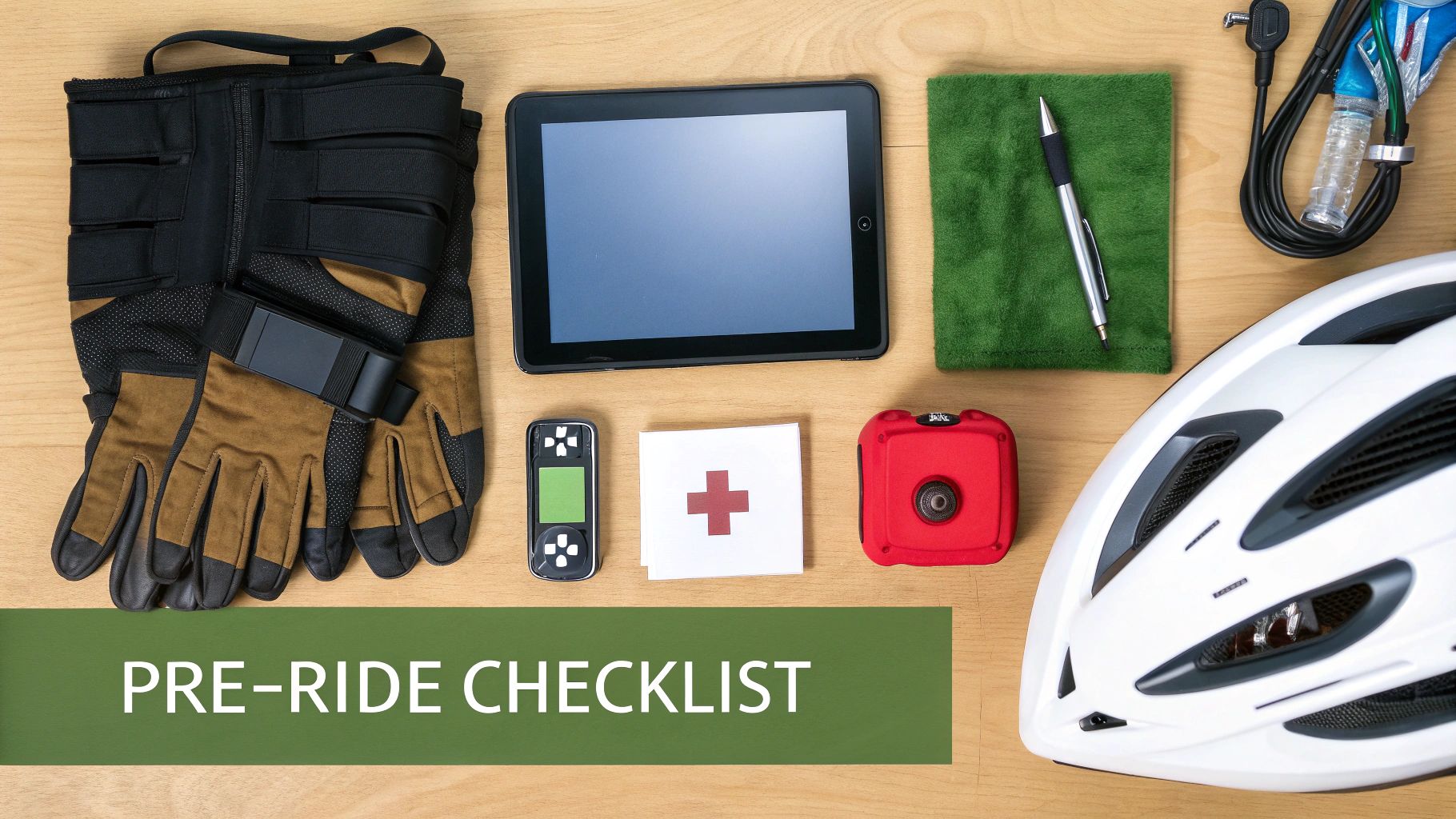
Having a good map is a great start, but it’s only one piece of the puzzle. The real secret to a fantastic day on the trails comes down to the prep work you do before you even load up the machine. Thinking ahead lets you enjoy the ride instead of worrying about what could go wrong.
This isn't just about ticking boxes; it's about making smart habits part of your routine. Before any ride, your first move should be to check the official website for the club or trail system you're hitting. Things change fast out there—seasonal closures, surprise trail washouts, or even active logging operations can pop up without warning, and the club’s site is where you’ll find the latest info.
Verify Your Access and Permits
Showing up to a trailhead only to realize you have the wrong permit is a surefire way to ruin a trip. Always, always double-check which pass is required for the specific network you plan to ride. An OFATV pass won’t get you onto a trail system managed by a private, non-affiliated club.
- Confirm Permit Validity: Make sure your pass is current for the season.
- Check Local Rules: Some trail systems have specific rules, like restrictions on engine size or machine width.
- Review Trail Status: A quick scan of the club’s website or social media feed can alert you to last-minute closures or reroutes.
Taking a few minutes to do this can save you from a major headache, a long drive home, or a hefty fine.
A great map tells you where the trail should be, but only a pre-ride check tells you if it's actually open and safe to use today. Never skip this step.
Essential Safety Preparations
Once you know your route is good to go and your permits are sorted, it’s time to think about safety. The scale of Ontario's trail network is massive. Just consider the roughly 6,000 kilometres maintained by Algonquin Trail Ventures Ontario (ATVO) alone. When you’re dealing with systems that big, with five interconnected 'nodes' stretching across the province, being self-sufficient isn’t optional—it’s essential.
Before you head out, make sure someone reliable knows your route and when you expect to be back. Pack an emergency kit with more than just a simple first-aid kit; include basic tools, a tire plug kit, and a portable air pump. And finally, be honest about your own skill level and what your machine can handle. Pushing it too far is how most accidents happen. A safe return is what makes any adventure a true success.
Got Questions About Ontario ATV Trail Maps? We’ve Got Answers.
Even with the best tools and a solid plan, questions are bound to pop up. Let's face it, navigating Ontario's massive trail network can get complicated, especially when you're trying to line up a great ride with a good hunting spot. Here are some of the most common things riders ask.
So, Can I Just Ride My ATV on Any Crown Land Trail I See?
Not exactly. While a huge chunk of Ontario's Crown Land is open for exploration, it's definitely not a free-for-all. You'll run into trails that are closed for environmental reasons, some that are specifically marked for non-motorized use like hiking, or trails that unexpectedly cross through private property.
This is exactly why just looking at a satellite image won't cut it. You need a real ontario atv trails map that shows you the difference between General Use Crown Land and other restricted areas.
My rule of thumb for the backroads has always been: "If you don't know, don't go." It's so much better to stick to a trail you know is legal than to accidentally trespass and end up with a fine or, worse, damage a sensitive area. Always check your route against local club maps—they're the ones who know all the specific access rules.
What's the Deal with OFATV vs. EOTA Permits?
Think of it like this: they're passes to two different, massive trail systems that sometimes link up. An OFATV (Ontario Federation of All-Terrain Vehicles) permit gets you onto the huge network managed by their member clubs, which you'll find mostly across southern and central Ontario.
An EOTA (Eastern Ontario Trail Alliance) permit, on the other hand, is for their specific multi-use trail system in, you guessed it, Eastern Ontario. While their networks might touch or even cross, you need the right permit for the trail you're physically on. If you're planning a long haul, make sure you know which permits you'll need for the entire trip to keep things legal and hassle-free.
Can I Add a Missing Trail Map to My Favourite App?
Absolutely. Most of the better mapping apps out there, including HuntScout and many dedicated GPS platforms, let you import GPX files. A GPX file is basically a digital map of a route, full of tracks and waypoints.
Lots of ATV clubs in Ontario offer these GPX files on their websites, usually as a benefit for members. You just download the file and use the "import" feature in your app. Just like that, you've layered the club's super-detailed trail data right onto your main map.
This is a game-changer because you can combine the powerful features of your app—like satellite views and property lines—with the ground-truth accuracy that only a local club's official trail file can provide.
Are Digital Maps Enough, or Should I Still Carry Paper?
Digital maps are fantastic, especially when you can download them for offline use. But let's be real, technology can fail. Batteries die, phones get dropped and broken, and software can glitch at the worst possible time.
This is why I always—and I mean always—have a physical, waterproof paper map of the area and a good old-fashioned compass in my pack. It's cheap insurance. Your phone or GPS will be your go-to, but that paper map is what guarantees you can find your way back if your tech gives up on you.
Ready to stop guessing and start riding with confidence? HuntScout gives you the multi-layered maps you need to see official ATV trails, Crown Land boundaries, and WMU information all in one place. Download the app and build your ultimate Ontario adventure map today.

