Public hunting land near you is found by switching on the federal and state ownership layers of a hunting map, then confirming with the managing agency that hunting, the season and your access route are all legal before you go. The largest single block in the country is the roughly 245 million acres the Bureau of Land Management oversees, mostly across 12 western states, where hunting is generally allowed unless a specific closure applies.
Now the situation you're probably in. It's ten days before the opener, you've got a tag and one free Saturday, and your phone shows a green blob 35 minutes from the house. It looks enormous. It also looks like a road runs straight into the middle of it.
That road is the first thing to verify, and it's usually the first thing to fail. Parcels that look wide open on a screen turn out to need a gate code, cross a hayfield, or sit in a unit where your tag isn't valid. Finding land isn't the hard part. Ranking what you found by whether you can legally stand on it with a rifle or a bow on the one day you have free is the hard part. That ranking runs in the same order every time: agency, season, entry, quality, retrieval.
Table of Contents
- Which Public Land Is Near You and Who Manages It
- Check Licenses, Seasons and Hunting Rules First
- How to Find Public Land Near You in Five Steps
- Confirm Access Has Not Changed Since Last Season
- Judge Pressure, Terrain and Retrieval Before You Commit
- Save Offline Maps and Confirm Before You Go
Which Public Land Is Near You and Who Manages It
The land belongs to one of a handful of owners, and the owner decides almost everything downstream. The U.S. Fish and Wildlife Service defines public land broadly to include land owned by federal, state or local governments, naming national forests, wildlife refuges, state parks and wildlife management areas, and that breadth is exactly where hunters get tripped up. Public-land hunting isn't a niche pursuit either. The same federal survey series counted more than 6 million hunters, or 44% of all hunters, using publicly owned land in 1991, including 2.1 million who hunted public ground exclusively.
Four different agencies can own four parcels within ten miles of each other, and each carries its own seasons, access rules and phone number. Sort by drive time first and you'll be standing at a locked gate at 5 a.m.
| Land type | Managing agency | Typical hunting status | Where to confirm |
|---|---|---|---|
| Bureau of Land Management land | Bureau of Land Management | About 245 million acres, mostly in 12 western states; hunting generally allowed unless closed | BLM field office and state wildlife agency |
| National Forest land | U.S. Forest Service | Large share of western and mountain public land; hunting allowed under state law and forest rules | Forest Service ranger district and state wildlife agency |
| National wildlife refuges | U.S. Fish and Wildlife Service | Hunting only in designated areas, seasons and hunt dates | Refuge office and refuge hunt brochure |
| State wildlife management areas | State wildlife agency | Usually open to public hunting under state rules; some areas need a permit or have restricted zones | State wildlife agency area map |
| State forest and trust land | State forest or land trust agency | Access and hunting vary by state and by parcel | State land agency and parcel-level rules |
Owner first, distance second
Ask two questions about every parcel on your screen. Who owns the dirt, and who sets the season? They're different answers more often than new hunters expect.
A BLM field office can tell you about closures, road conditions and local shooting restrictions. A Forest Service ranger district handles gates, fire closures and road status on its district. A refuge office owns the hunt dates and the brochure that defines open units. The state wildlife agency owns seasons, tags, unit boundaries and weapon rules, and it does that on federal land too.
State trust land is the row people get wrong most often. A trust parcel can be leased to a single hunting club, which locks everyone else out for the year even though the map paints it green. Wildlife management areas carry restricted zones and permit requirements that don't show up in a search result.
A green polygon is a starting point, not permission.
Before you plan a single trip, build a list. Parcel name, managing agency, the specific office that answers for it, and the date you checked. Two contacts per parcel, land manager and state wildlife agency. That list does more work for you than any filter in any app.
Check Licenses, Seasons and Hunting Rules First
Run the paperwork check first, because it can disqualify a parcel before you spend a minute on access. The land manager decides whether you can be on the ground. The state wildlife agency decides whether you can hunt, what you can carry and when. On BLM ground, the Bureau of Land Management states that hunting is generally allowed unless a specific closure or prohibition applies, and the state still controls the license, tags, seasons, unit boundaries and weapon rules. That split is why identical federal ground can hunt completely differently on either side of a state line.
Paper first, boots second.
| Check | Where to confirm | Why it matters |
|---|---|---|
| Hunting license and tags | State wildlife agency | Federal land does not replace state licensing |
| Season dates and unit boundaries | State wildlife agency unit maps | Dates and units change by species and year |
| Weapon and distance limits | State regulations and BLM field office | Some states bar shooting near dwellings or from roads |
The distance and vehicle rules that catch people out
Weapon and distance limits are where experienced hunters still collect citations, because they read the hunting proclamation and never read the land manager's guidance. Field offices publish local rules that surprise people. Minimum distances apply around dwellings and buildings unless you have the owner's permission. Shooting from or across a graded or public road, or from a motor vehicle, is illegal. Hunting and trapping are restricted near developed recreation sites, and on most public land you may not drive off existing roads and trails, even to recover downed game.
Licensing adds a second layer on top of the base license. Stamps, validations and habitat fees vary by state and by species, so pull the current year's requirements from the state wildlife agency for the exact unit you plan to hunt rather than assuming a standard license covers everything.
Confirm each check with the office that controls it, not the one that is easiest to reach. Licensing and seasons go to the state wildlife agency. Local shooting and vehicle guidance goes to the field office that manages the parcel. No date, distance or limit belongs in your plan until you have confirmed it for the current year.
Rules keep you legal. Preparation covers the rest, and a little time on staying safe during deer season belongs in the same pre-trip pass as your tag check, especially on a solo public-land hunt where help is an hour away. A hunting app that carries real-time regulations keeps season dates and rule summaries in front of you, so you are checking current information rather than last year's notes.
How to Find Public Land Near You in Five Steps
Run this sequence on any new area and you'll eliminate the bad candidates before you burn a scouting day. The order matters, because each step filters out parcels the next step would waste time on.
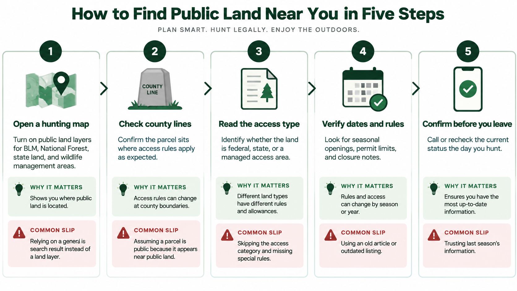
1. Turn on the land layers. Open a hunting map and switch on BLM, National Forest, state land and wildlife management areas at the same time, so you're reading ownership rather than a single shade of green. HuntScout, onX Hunt, HuntStand and iHunter all carry public land layers; they differ in coverage and price, not in whether the data exists. The common slip is trusting a general search result that shows a shape but never names the owner.
2. Read the parcel card. Tap the parcel and read the owner, the managing agency, the county line and the hunt unit or zone boundary. A parcel in a neighbouring unit can carry a different season even when it touches the ground you planned to hunt. People miss that because the map doesn't shout about boundaries.
3. Check the season and weapon for that unit. Public and closed to your hunt are entirely compatible facts. A unit can be open for archery in September and shut to your rifle tag in October, and a wildlife management area can require a permit on top of a general license.
4. Confirm legal entry. Trace the actual road or trail from pavement to where you'd park. Check gate status, walk-in routes, water crossings and whether any part of that route crosses private ground. Most "accessible" parcels die here. A road line on a screen says nothing about a locked gate or a landowner who closed a crossing two years ago.
5. Save it and take it offline. Drop waypoints on the entry point, the glassing spots and the pack-out line, then download the offline map while you still have signal. Save the backup parcel inside the same downloaded area.
What usable looks like: legal entry, an open season, a clear route in and out, and a retrieval line that stays on roads and trails you're allowed to use.
In bear country, that last point is worth reading twice. Walking in before daylight and dragging out after dark is exactly when encounters happen, so spend ten minutes on understanding bear behavior before an encounter from Counter Assault before you commit to a drainage you've never set foot in. When you're ready to check parcels against state maps, the US public land tool is the layer view to start from.
Confirm Access Has Not Changed Since Last Season
The parcel that worked last November may still look like a solid pin this October while its legal status has already changed. A saved map records a boundary. It does not prove that you may enter, hunt or cross the route this season.
Before sorting candidates by distance, sort each one by the kind of access behind it. Access comes in four flavors, and only one of them is close to fixed.
| Access type | Who controls it | Can it change | Check before you go |
|---|---|---|---|
| Federal or state ownership | Land agency | Rarely, but closures happen | Agency closure notice |
| Walk-in or state access program land | Enrolled private landowner under a state program | Yes, enrollment can end | Current program enrollment list |
| Leased hunting land | Lessee under written terms | Yes, the lease can end | Lease terms and written permission |
| Private land with landowner permission | Landowner | Yes, permission can be withdrawn | Written permission in hand |
Federal and state ownership is the most stable category. The other three depend on enrollment, a lease or a landowner's permission, so a listing saved two seasons ago is not evidence of current access.
Access can grow as well as disappear. USDA reports that over a two-year period, state public-access programs helped open an estimated 2.4 million acres on privately owned land. That makes current enrolled private ground worth considering alongside federal parcels, but enrollment cuts both ways. A landowner can leave a state program, and a parcel that appeared on last year's list can lose access before this season.
Record the date and the name
Every parcel in your list gets two extra fields: the date you last verified it, and the name of the person or office that confirmed it. That small record turns "it was open last year" into a verification you can judge by age and source.
For federal parcels, closure notices come from the BLM field office or the Forest Service ranger district. For state land and wildlife management areas, they come from the state wildlife agency. For walk-in ground, compare the parcel with the current enrollment list. For leased or permission-only ground, confirm the written terms still cover your season and route.
Check those notices the day you plan to leave, not the day you found the parcel. A confirmation from months ago may be accurate, but it is not a substitute for the final check.
Treat uncertainty as a cost when ranking candidates. If the owner or agency cannot confirm a parcel's current status, move it down the list and keep a backup parcel named for the trip. I would rather drive past a closer parcel than build a hunt around access nobody can verify.
The "public land hunting near me" question has two parts: whether the land is close, and whether an agency, enrollment list, lease or landowner can still support your right to enter this season.
Judge Pressure, Terrain and Retrieval Before You Commit
A legal parcel can still be a poor choice, and the reasons are usually pressure and retrieval rather than regulations. Hunters pour into the first half mile off the road, and the animals respond by moving into cover that's further in and uglier to reach.
The concentration is measurable. A Forest Service research summary reports that elk hunters commonly traveled up to 2 miles from open roads, and that all three hunter groups in the study used less than 16% of the available study area. In the same six-year northeastern Oregon study of 416 hunters, pre-season scouting increased rifle-elk success odds by 418%, and each additional hour per day hunting outside camp increased success odds by 18%. Vehicle use, age and experience weren't useful predictors once effort and scouting were accounted for.
Quality varies too, even on legal ground. A Kentucky Department of Fish and Wildlife survey of public-land deer hunters found that nearly one-quarter rated public-land quality only Fair or Poor, while just 30% rated it Very good or Excellent. Only 17% said they hunted public land because they lacked private-land access, so most of that pressure is a choice rather than a last resort. A crowded parcel twenty minutes away can hunt worse than a quieter one twice as far, which is why I rank candidates by usable ground and not by drive time.
The checklist I'd run on the map
- Distance from the nearest open road: if the parcel is a roadside strip, expect company and plan accordingly.
- Cover and water: bedding cover and a water source inside the parcel boundary, not on the neighbouring ranch.
- An escape area on public ground: somewhere for animals to go that stays legal for them and reachable for you.
- A retrieval route on legal roads and trails: the one hunters forget until they're standing over an animal at last light.
- Adjacent private land: a clear boundary line you can see, so a tracking job doesn't become a trespass.
Retrieval is where the map check turns into phone calls. Motorized-use limits differ by unit and by season, so before you assume you can leave existing roads and trails to reach a downed animal, confirm the rules with the BLM field office and the state wildlife agency that manage that ground. A two-track that looks passable on a screen can be closed to the vehicle you brought, and the answer decides whether the parcel stays on your list.
The test: if you can't describe the retrieval route out loud, in order, the parcel isn't finished yet.
Then go scout it. The Oregon numbers already told you what effort buys: the crowd stops where the walking gets hard, and pre-season time on the ground is worth more than anything your truck can do for you. Walk the pack-out line before the season, while a wrong turn costs you an afternoon instead of a recovery in the dark.
Save Offline Maps and Confirm Before You Go
The last failure is the quiet one. You drive out, the signal drops, and the gate you saw online is chained, or the road you planned to park on is posted.
Do the downloads the night before, while you still have bars. Pull the offline map covering the parcel, the entry point and the entire route out, and keep your backup parcel inside the same downloaded area so a failed plan doesn't need a second download. Drop waypoints on the parking spot, the glassing points and the pack-out line. Then send the saved map and your planned exit time to a partner or someone at home, because a shared map is what turns a search into a pickup.
The sequence I'd run before turning the key
- Verify the managing agency's current rules for the season you're hunting.
- Confirm the access route and closure status for that specific parcel.
- Check that the offline plan covers the full route, including the walk out in the dark.
- Drive only after all three hold. If any one fails, switch to the backup parcel and run the sequence again.
The reason for the order is that a closure posted Friday afternoon won't appear in any app by Saturday morning. Map data plans the trip; posted signs and current closure notices control what you can do in the field. A guide to using offline maps for hunting covers the download and waypoint mechanics if you haven't built that habit yet.
Verification is a habit, not a season-long project. Ten minutes per parcel, before every trip, is the whole cost.
One action makes the biggest difference. Before you leave home, open the managing agency's current notice for your chosen parcel and read it. If it doesn't confirm your plan, your backup parcel is already saved and waiting.
HuntScout was built for exactly this workflow: tap any parcel to see whether it's BLM, National Forest, state land or a wildlife management area, see which hunting unit you're standing in, and follow the link to the official agency for the current season and rules. It covers the US, Canada and Australia on iPhone, Android and the web, with offline maps, waypoints and shared party maps for the places where your signal won't follow you. Start with the public land layer before your next trip and rank your parcels by usability instead of distance.